
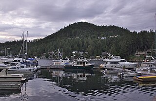
Bowen Island, British Columbia, is an island municipality that is part of Metro Vancouver, and within the jurisdiction of the Islands Trust. Located in Howe Sound, it is approximately 6 kilometres (3.7 mi) wide by 12 kilometres (7.5 mi) long, and at its closest point is about 3 kilometres (1.9 mi) west of the mainland. There is regular ferry service from Horseshoe Bay provided by BC Ferries, and semi-regular water taxi services. The population of 4,256 is supplemented in the summer by about 1,500 visitors. It has a land area of 50.12 km2 (19.35 sq mi).
British Columbia Ferry Services Inc., operating as BC Ferries (BCF), is a former provincial Crown corporation, now operating as an independently managed, publicly owned Canadian company. BC Ferries provides all major passenger and vehicle ferry services for coastal and island communities in the Canadian province of British Columbia. Set up in 1960 to provide a similar service to that provided by the Black Ball Line and the Canadian Pacific Railway, which were affected by job action at the time, BC Ferries has become the largest passenger ferry line in North America, operating a fleet of 41 vessels with a total passenger and crew capacity of over 27,000, serving 47 locations on the B.C. coast.
British Columbia Highway 101, also known as the Sunshine Coast Highway, is the main north–south thoroughfare on the Sunshine Coast, British Columbia, Canada.

Powell River is a city on the northern Sunshine Coast of southwestern British Columbia, Canada. Most of its population lives near the eastern shores of Malaspina Strait, which is part of the larger Georgia Strait between Vancouver Island and the Mainland. With two intervening long, steep-sided fjords inhibiting the construction of a contiguous road connection with Vancouver to the south, geographical surroundings explain Powell River's remoteness as a community, despite relative proximity to Vancouver and other populous areas of the BC Coast. The city is the location of the head office of the qathet Regional District.
The Sunshine Coast is a geographic subregion of the British Columbia Coast that generally comprises the regional districts of qathet and Sunshine Coast.

Earls Cove is a small settlement located on Jervis Inlet in the Sunshine Coast region of British Columbia. It is a terminal for the BC Ferries route across the inlet to Saltery Bay, linking the Lower Sunshine Coast with the Upper Sunshine Coast. Earls Cove is at the north end of the Sechelt Peninsula and on the east side of the mouth of Jervis Inlet, adjacent to Agamemnon Channel, across which is Nelson Island.
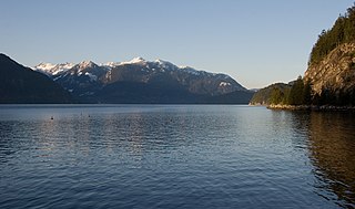
Howe Sound is a roughly triangular sound, that joins a network of fjords situated immediately northwest of Vancouver, British Columbia, Canada. It was designated as a UNESCO Biosphere Reserve in 2021.

The British Columbia Coast, popularly referred to as the BC Coast or simply the Coast, is a geographic region of the Canadian province of British Columbia. As the entire western continental coastline of Canada along the Pacific Ocean is in the province, it is synonymous with being the West Coast of Canada.

Holberg is a former ferry terminal about 35 kilometres (22 mi) from the northwest tip of Vancouver Island, British Columbia. This unincorporated community is at the head of Holberg Inlet, which forms the western arm of Quatsino Sound.

MV Queen of Surrey is a double-ended C-class roll-on/roll-off ferry in the BC Ferries fleet. The ship was launched in 1980 and entered service in 1981. The ferry normally operates on BC Ferries' Horseshoe Bay to Langdale route. She is named for the city of Surrey. On May 12, 2003, Queen of Surrey suffered an engine fire that disabled the ferry in Howe Sound. No one was injured and the ship was returned to service. In 2004, the ferry was involved in a collision with a tugboat, and in 2019 she struck a fixed structure at the Langdale terminal. The 2019 crash lead to passengers being stranded on the vessel for over ten hours.
Woodfibre, originally Britannia West, was a pulp mill and at one time a small company town, on the west side of upper Howe Sound near Squamish, British Columbia. The mill closed in March 2006.
Gambier Island is an island located in Howe Sound near Vancouver, British Columbia. It is about 17,049 acres in size and is located about 10 kilometres north of the Horseshoe Bay community and ferry terminal in westernmost West Vancouver.

Lund is a small craft harbour and unincorporated village on Tla'amin land in qathet Regional District, British Columbia, Canada. It is along the northern part of the Salish Sea on the mainland BC coast. The main landmark in the village is the Lund Hotel, established in 1905. By boat from Lund, the Copeland Islands and Desolation Sound, are nearby. Lund is home to many shops and services including a general store, a restaurant overlooking the water, kayak and adventure tourism stores, and Nancy's Bakery, a favourite of locals and tourists.

Keats Island is an inhabited island located in Howe Sound near Vancouver, British Columbia. Around eighty people live on Keats Island year-round.

Port Mellon is a settlement in British Columbia, Canada, located within the territory of the Squamish Nation, and part of West Howe Sound, Electoral Area F within the Sunshine Coast Regional District (SCRD). Port Mellon is the home to the region's largest employer, the Howe Sound Pulp & Paper Mill.

Horseshoe Bay is a major ferry terminal owned and operated by BC Ferries in British Columbia, Canada. Located in the community of Horseshoe Bay, a neighbourhood of West Vancouver, the terminal provides a vehicle ferry link from the Lower Mainland to Vancouver Island, the Sunshine Coast, and to Bowen Island, a small island in the southern part of Howe Sound.
West Howe Sound, also known as SCRD Electoral Area F, is an electoral area of the Sunshine Coast Regional District (SCRD), in British Columbia, Canada. It is bound on the south by the Town of Gibsons, on the west by Elphinstone, on the east by Howe Sound, on the north by Squamish-Lillooet Regional District Electoral Area D, and on the southeast by Metro Vancouver Regional District Electoral Area A.

Nanaimo Harbour, also known as the Port of Nanaimo, is a natural harbour on the east coast of Vancouver Island in the Canadian province of British Columbia. The city of Nanaimo runs along the west side of the harbour. Three islands, Newcastle, Protection, and Gabriola, along with Duke Point, form the eastern edge. The Port of Nanaimo includes the Inner Harbour, Nanaimo River estuary, Departure Bay, the waters on the east side of Newcastle and Protection Islands, and Northumberland Channel. The port is under the management of the Nanaimo Port Authority.

Langdale is a ferry terminal owned and operated by BC Ferries, which provides ferry services from the Sunshine Coast to the Lower Mainland, Gambier Island, and Keats Island in the Canadian province of British Columbia.

