British Columbia Coast

Last updated
British Columbia Coast
French: Côte de la Colombie-Britannique
Concord Pacific Master Plan Area.jpg
Sandstone bluffs along the Vancouver Island Coast.jpg
Lax Kw'alaams.jpg
French Creek, British Columbia.jpg
Nickname: 
"The Coast"
CountryCanada
Province British Columbia
Principal cities
Area
[1]
  15 Districts244,778 km2 (94,509 sq mi)
Highest elevation4,019 m (13,186 ft)
Lowest elevation0 m (0 ft)
Population
 (2016)
3,686,900 [2]
  Density80.24/km2 (207.8/sq mi)
Time zone UTC−08:00 (PST)
  Summer (DST) UTC−07:00 (PDT)
Postal code prefixes
V
Area codes 236, 250, 604, 672, 778

The British Columbia Coast, popularly referred to as the BC Coast or simply the Coast, is a geographic region of the Canadian province of British Columbia. As the entire western continental coastline of Canada along the Pacific Ocean is in the province, it is synonymous with being the West Coast of Canada.

Contents

While the exact boundaries are variously defined, the region is generally defined to include the 15 regional districts that have coastline along the Pacific Ocean or Salish Sea, or are part of the Lower Mainland, a subregion of the British Columbia Coast. Other boundaries may exclude parts of or even entire regional districts, such as those of the aforementioned Lower Mainland.

Boundaries

While the term British Columbia Coast has been recorded from the earliest period of non-native settlement in British Columbia, it has never been officially defined in legal terms. The term has historically been in popular usage for over a century to describe a region of the province that extends west from the Coast Mountains and North Cascades. This definition makes the term British Columbia Coast largely synonymous with the 15 regional districts that have territory in this region.

Major subregions

Among locals, the British Columbia Coast can further be divided into seven major subregions:

History

Research from the 1990s has indicated that the Ice Age-era coastline of the British Columbia Coast was lower by about 100 m (330 ft). The effect of the sea level on the coastline was such that Queen Charlotte Sound, which is between Haida Gwaii and the northern end of Vancouver Island, was a coastal plain, as were all the straits inland from it, except for those that were mountain valleys.

Underwater archaeology has shown the presence of permanent human habitations and other activity at the 100 m (330 ft) contour, and the Ice Age existence of such a coastal plain has put a new light on Ice Age populations in North America as well as on the strong likelihood of this area having been the major migration route from (and perhaps to) Asia.

The heavy indentation and mild climate of the British Columbia Coast have led to inevitable comparisons with the geography's predisposition to encouraging increased human settlement and movement as well as cultural foment and population growth in the Aegean, the Irish Sea/Hebrides and in the Danish Archipelago and adjoining Scandinavian coasts.

The natural fecundity of the environment - rich in seafood, wild game, and greenery - combined with the ease of travel (by water) is seen in all cases (British Columbia, Denmark, Greece) to have generated a dynamic and gifted civilization. And there are comparisons to be made between the artistic and political and social level of the Pacific Northwest Peoples and those of pre-Conversion pagan Scandinavia, Ireland and Archaic-Era Greece. [ citation needed ]

Geography

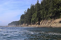
The British Columbia Coast stretches from the southern tip of Vancouver Island along the Strait of Juan de Fuca to the community of Stewart at the head of Portland Canal. The aerial distance between these two points is approximately 954 km (593 mi). However, due to its deeply incised coastline and over 40,000 islands of varying sizes, the total length of the British Columbia Coast is over 25,725 km (15,985 mi), or approximately 10% of the entire Canadian coastline. This coastal geography is shared with the neighbouring U.S. states of Alaska and Washington. [4]

The dominant landforms are the Insular Mountains of Vancouver Island and Haida Gwaii, and the Coast Mountains that stretch along the entire length of the coast. The proximity of these mountains to the coast produce fjords that rival those of Norway in length and depth. Several large Islands fill the strait between Vancouver Island and the Mainland with Texada Island, Cortes Island and Salt Spring Island being the largest in size. Fjords of note include Burrard Inlet, Burke Channel, Howe Sound, Jervis Inlet, Desolation Sound, Dean Channel, Douglas Channel, and Portland Inlet.

Climate

The BC Coast is dominated by a moderate oceanic climate (Köppen: Cfb) with warm summers, cool winters, and constant rainfall that peaks during the winter months. These areas enjoy the mildest winter weather in all of Canada, as temperatures rarely fall below freezing.

The southernmost region of the coast (surrounding the Salish Sea) features a warm-summer Mediterranean climate with warm, dry summers and cool, wet winters. This gradually transitions to a predominantly oceanic climate in the north along the coast and further inland into the foothills of the Pacific Ranges. Higher elevations feature a subpolar oceanic climate (Köppen: Cfc) with cool summers, cold winters, and constant rainfall that peaks during the winter months. The highest elevations feature a subarctic climate (Köppen: Dfc).

Ecology

Temperate rainforest ecosystem in Garibaldi Provincial Park Garibaldi National Park - Garibaldi Mountain.jpg
Temperate rainforest ecosystem in Garibaldi Provincial Park

The British Columbia Coast is dominated by temperate rainforest. According to the ecoregion system used by the World Wide Fund for Nature (WWF), the BC Coast is part of five distinct ecoregions: Puget lowland forests, Central Pacific coastal forests, British Columbia mainland coastal forests, Haida Gwaii coastal forests, and Pacific Coastal Mountain icefields and tundra.

According to the ecozone system used by Environment and Climate Change Canada (ECCC), the BC Coast is part of four distinct ecozones: Pacific Coastal Mountains, Coastal Western Hemlock-Sitka Spruce Forests, Pacific and Nass Ranges, and Strait of Georgia/Puget Lowland.

According to the British Columbia Ministry of Forests, which uses an ecosystem classification system independent of the WWF and ECCC, the BC Coast is part of two distinct biogeoclimatic zones: Coastal Western Hemlock and Coastal Douglas-fir.

Demographics

Regional districts

Below are the 15 regional districts of British Columbia defined as being in the Coast region:

British Columbia regional districts as of January 29,2020 [5]
NamePopulation
(2016) [2] [6]
Area
(km2)
Density
(/km2)
Head office
location
Alberni-Clayoquot 30,9816,5884.7 Port Alberni
Capital 383,3602,340163.8 Victoria
Central Coast 3,31924,4920.14 Bella Coola
Comox Valley 66,5271,70139.1 Courtenay
Cowichan Valley 83,7393,47524.1 Duncan
Fraser Valley 295,93413,33522.2 Chilliwack
Kitimat–Stikine 37,367104,4610.36 Terrace
Metro Vancouver 2,463,4312,883854.5 Burnaby
Mount Waddington 11,03520,2440.55 Port McNeill
Nanaimo 155,6982,03876.4 Nanaimo
North Coast 18,13319,7810.92 Prince Rupert
qathet 20,0705,0754.0 Powell River
Squamish-Lillooet 42,66516,3102.6 Pemberton
Strathcona 44,67118,2782.4 Campbell River
Sunshine Coast 29,9703,7777.9 Sechelt

Culture

'Namgis Big House and totem pole near Alert Bay Namgis Big House (9411102177).jpg
ʼNamgis Big House and totem pole near Alert Bay

Economy

Fishing

Trawling for herring in the Salish Sea Herring fishing, day one.jpg
Trawling for herring in the Salish Sea

The fishery of the Pacific Northwest Coast is legendary, especially for its many salmon runs and the cultures that built on top of them throughout the region. Salmon runs have greatly diminished since pre-Contact years and the advent of commercial canning and, ultimately, depletion of stocks by high-seas fishing.

Other commercial fisheries include halibut, herring and herring roe, sea urchin and other specialty sushis, hake, haddock, cod, crab and shellfish.

Transportation

Highways

The Coast Region of B.C is connected to the rest of B.C by various roads depending on the region.

The populous Fraser Valley and Lower Mainland is linked to the rest of the province by Highway 1 (Fraser Canyon Highway), Highway 5 (Coquihalla Freeway), Highway 3 (Crowsnest Highway) and Highway 99 (Sea to Sky Highway). The Lower Mainland is also connected to the U.S. by four highway border crossings with the Peace Arch on Interstate 5 being the largest. Several freeways connect lower mainland communities together.

The backbone of Vancouver Island's highway network is the Highway 19 which along with a portion of Highway 1 forms the Island Highway. The Island highway is a mix of 4-lane freeway, 4 lane arterial highway and 2 lane highway running roughly along the east shore of Vancouver Island. Access to the west coast of Vancouver Island can be accomplished by crossing mountain passes on Highway 4 to Tofino and Highway 28 to Gold River. Thousands of other roads ranging from small freeways near Victoria to logging roads exist all over the Island.

Although the Sunshine Coast is on the mainland it is connected to the highway network only by ferries. It has one route which is Highway 101, a narrow curvy 2 lane road split in two by a ferry crossing. Texada Island, a large island off the Sunshine Coast and has its own network of highway standard roads although they are unnumbered.

Owing to the challenging topography of the British Columbia Coast, there is no north–south highway linking the coastal communities of the province between Port Hardy and Kitimat. Instead, travellers utilize one of the coastal ferry lines operated by BC Ferries. The exceptions are Bella Coola is accessible by a long largely gravel Highway 20 from the B.C interior over a high pass; and the towns of Terrace, Prince Rupert and Kitimat which is assessed from the B.C. interior on Highway 16.

Haida Gwaii has an extension of Highway 16 on it, one of Haida Gwaii's few paved roads.

Maritime routes

BC Ferries' Northern Expedition sails daily along the Inside Passage route connecting Prince Rupert and Port Hardy MV Northern Expedition, Nanaimo, March 6 2009(2).jpg
BC Ferries' Northern Expedition sails daily along the Inside Passage route connecting Prince Rupert and Port Hardy

The sheltered waterways of the British Columbia Coast form part of the Inside Passage, a coastal maritime route along which vessels navigate to avoid the rough waters and bad weather of the open North Pacific. As such, the maritime route is heavily trafficked by cruise ships, cargo ships, ferries, and other marine vessels.

BC Ferries, an independently managed publicly-owned company, operates scheduled daily crossings between major population centres throughout the British Columbia Coast. Dozens of smaller ferries ply lesser routes within and between these regions. The Alaska Marine Highway also operates nonstop ferry service through the British Columbia Coast along its Bellingham-Ketchikan route. [7]

Ports

The Port of Vancouver is the largest commercial shipping port in all of Canada and along the entire Pacific Ocean / Pacific coast of North America by metric tons, which handles a total cargo volume of 76.5 million metric tons. [8] By the same metric, the Port of Vancouver is also the fifth largest commercial shipping port in North America. [9]

The Port of Prince Rupert possesses the deepest ice-free natural harbour in North America, and the 3rd deepest natural harbour in the world. [10] Situated at 54° North, the harbour is the northwesternmost port in North America linked to the continent's railway network. The port is the first inbound and last outbound port of call for some cargo ships travelling between eastern Asia and western North America since it is the closest North American port to key Asian destinations. [11] [12]


Rail

CPR train traversing the Stoney Creek Bridge Eastbound over SCB.jpg
CPR train traversing the Stoney Creek Bridge

See also

Related Research Articles

<span class="mw-page-title-main">British Columbia</span> Province of Canada

British Columbia is the westernmost province of Canada. Situated between the Pacific Ocean and the Rocky Mountains, the province has a diverse geography, with rugged landscapes that include rocky coastlines, sandy beaches, forests, lakes, mountains, inland deserts and grassy plains. British Columbia borders the province of Alberta to the east; the territories of Yukon to the north; the Northwest Territories to the northeast; the US states of Washington, Idaho and Montana to the south; and Alaska to the northwest. With an estimated population of over 5.5 million as of 2023, it is Canada's third-most populous province. The capital of British Columbia is Victoria, while the province's largest city is Vancouver. Vancouver and its suburbs together make up the third-largest metropolitan area in Canada; with the 2021 census recording 2.6 million people in Metro Vancouver.

<span class="mw-page-title-main">Vancouver Island</span> Largest island in British Columbia, Canada

Vancouver Island is an island in the northeastern Pacific Ocean and part of the Canadian province of British Columbia. The island is 456 km (283 mi) in length, 100 km (62 mi) in width at its widest point, and 32,100 km2 (12,400 sq mi) in total area, while 31,285 km2 (12,079 sq mi) are of land. The island is the largest by area and the most populous along the west coasts of the Americas.

<span class="mw-page-title-main">Haida Gwaii</span> Archipelago in British Columbia, Canada

Haida Gwaii, formerly known as the Queen Charlotte Islands, is an archipelago located between 55–125 km (34–78 mi) off the northern Pacific coast of Canada. The islands are separated from the mainland to the east by the shallow Hecate Strait. Queen Charlotte Sound lies to the south, with Vancouver Island beyond. To the north, the disputed Dixon Entrance separates Haida Gwaii from the Alexander Archipelago in the U.S. state of Alaska.

Highway 16 is a highway in British Columbia, Canada. It is an important section of the Yellowhead Highway, a part of the Trans-Canada Highway that runs across Western Canada. The highway closely follows the path of the northern B.C. alignment of the Canadian National Railway. The number "16" was first given to the highway in 1941, and originally, the route that the highway took was more to the north of today's highway, and it was not as long as it is now. Highway 16 originally ran from New Hazelton east to Aleza Lake. In 1947, Highway 16's western end was moved from New Hazelton to the coastal city of Prince Rupert, and in 1953, the highway was re-aligned to end at Prince George. In 1969, further alignment east into Yellowhead Pass was opened to traffic after being constructed up through 1968 and raised to all-weather standards in 1969. Highway 16's alignment on Haida Gwaii was commissioned in 1983 and is connected to the mainland segment via BC Ferries route #11.

<span class="mw-page-title-main">Prince Rupert, British Columbia</span> City in British Columbia, Canada

Prince Rupert is a port city in the province of British Columbia, Canada. Its location is on Kaien Island near the Alaskan panhandle. It is the land, air, and water transportation hub of British Columbia's North Coast, and has a population of 12,220 people as of 2016.

<span class="mw-page-title-main">Inside Passage</span> Shipping route along the northwest coast of North America

The Inside Passage is a coastal route for ships and boats along a network of passages which weave through the islands on the Pacific Northwest coast of the North American Fjordland. The route extends from southeastern Alaska in the United States, through western British Columbia in Canada, to northwestern Washington state in the United States. Ships using the route can avoid some of the bad weather in the open ocean and may visit some of the many isolated communities along the route. The Inside Passage is heavily travelled by cruise ships, freighters, tugs with tows, fishing craft, pleasure craft, and ships of the Alaska Marine Highway, BC Ferries, and Washington State Ferries systems. Coast Guard vessels of both Canada and the United States patrol and transit in the Passage.

<span class="mw-page-title-main">Hecate Strait</span> Strait between Haida Gwaii and mainland British Columbia

Hecate Strait is a wide but shallow strait between Haida Gwaii and the mainland of British Columbia, Canada. It merges with Queen Charlotte Sound to the south and Dixon Entrance to the north. About 140 kilometres (87 mi) wide at its southern end, Hecate Strait narrows in the north to about 48 kilometres (30 mi). It is about 260 kilometres (160 mi) in length.

<span class="mw-page-title-main">Sunshine Coast (British Columbia)</span> Subregion of British Columbia in Canada

The Sunshine Coast is a geographic subregion of the British Columbia Coast that generally comprises the regional districts of qathet and Sunshine Coast.

<span class="mw-page-title-main">North Coast (provincial electoral district)</span> Provincial electoral district in British Columbia, Canada

North Coast is a provincial electoral district for the Legislative Assembly of British Columbia, Canada. It was created by 1990 legislation which came into effect for the 1991 election, largely out of the previous riding of Prince Rupert.

<span class="mw-page-title-main">Gwaii Haanas National Park Reserve and Haida Heritage Site</span> National park reserve and heritage site in British Columbia, Canada

Gwaii Haanas National Park Reserve, National Marine Conservation Area, and Haida Heritage Site, usually referred to simply as Gwaii Haanas, is located in southernmost Haida Gwaii, 130 kilometres off the mainland of British Columbia, Canada. Gwaii Haanas protects an archipelago of 138 islands, the largest being Moresby Island and the southernmost being Kunghit Island. "Gwaii Haanas" means "Islands of Beauty" in X̱aayda kíl, the language of the Haida people.

<span class="mw-page-title-main">Geography of British Columbia</span> Overview of the geography of British Columbia

British Columbia is the westernmost province of Canada, bordered by the Pacific Ocean. With an area of 944,735 km2 (364,764 sq mi) it is Canada's third-largest province. The province is almost four times the size of the United Kingdom and larger than every United States state except Alaska. It is bounded on the northwest by the U.S. state of Alaska, directly north by Yukon and the Northwest Territories, on the east by Alberta, and on the south by the U.S. states of Washington, Idaho, and Montana. Formerly part of the British Empire, the southern border of British Columbia was established by the 1846 Oregon Treaty. The province is dominated by mountain ranges, among them the Canadian Rockies but dominantly the Coast Mountains, Cassiar Mountains, and the Columbia Mountains. Most of the population is concentrated on the Pacific coast, notably in the area of Vancouver, located on the southwestern tip of the mainland, which is known as the Lower Mainland. It is the most mountainous province of Canada.

<span class="mw-page-title-main">Great Bear Rainforest</span> Coastal temperate rainforest in British Columbia, Canada.

The Great Bear Rainforest is a temperate rain forest on the Pacific coast of British Columbia, comprising 6.4 million hectares. It is part of the larger Pacific temperate rainforest ecoregion, which is the largest coastal temperate rainforest in the world.

<span class="mw-page-title-main">Masset</span> Village in British Columbia, Canada

Masset is a village in the Haida Gwaii archipelago in British Columbia, Canada. It is located on Masset Sound on the northern coast of Graham Island, the largest island in the archipelago, and is approximately 50 km (31 mi) west of mainland British Columbia. It is the primary western terminus of Trans-Canada Highway 16 and is served by Masset Airport, with flights to Vancouver and Prince Rupert. During the maritime fur trade of the early 19th century, Masset was a key trading site. It was incorporated as a village municipality on May 11, 1961.

<span class="mw-page-title-main">Port Renfrew</span> Unincorporated community on Vancouver Island in British Columbia, Canada

Port Renfrew is a small unincorporated community located on the south shore of Port San Juan, an inlet on the west coast of Vancouver Island in British Columbia, Canada. Port Renfrew has a population of 262 and has been touted as "the Tall Tree Capital of Canada".

<span class="mw-page-title-main">Sandspit, British Columbia</span> Community in Saskatchewan, Canada

Sandspit is the largest community on Moresby Island, in Haida Gwaii off the Pacific coast of British Columbia, Canada. The only town on Moresby Island, Sandspit has accommodations, a campground, supermarket and 85-berth harbour serving visitors to Gwaii Haanas.

<span class="mw-page-title-main">Johnstone Strait</span> Waterway between northern Vancouver Island and mainland British Columbia, Canada

Johnstone Strait is a 110 km (68 mi) channel along the north east coast of Vancouver Island in British Columbia, Canada. Opposite the Vancouver Island coast, running north to south, are Hanson Island, West Cracroft Island, the mainland British Columbia Coast, Hardwicke Island, West Thurlow Island and East Thurlow Island. At that point, the strait meets Discovery Passage which connects to Georgia Strait.

<span class="mw-page-title-main">Pacific Maritime Ecozone (CEC)</span>

The Pacific Maritime Ecozone, as defined by the Commission for Environmental Cooperation (CEC), is a Canadian terrestrial ecozone, spanning a strip approximately 200 kilometres wide along the British Columbia Coast, then narrowing along the border with Alaska. It also includes all marine islands of British Columbia and a small portion of the southwestern corner of the Yukon. Fourteen ecoregions comprise the Ecozone, ranging from the Mount Logan Ecoregion in the north to the Cascade Ecoregion and Lower Mainland Ecoregion in the south.

Mount Moresby is the highest mountain of the Queen Charlotte Mountains, located 26 km (16 mi) south of Daajing Giids on Moresby Island in British Columbia, Canada.

The Yakoun River is the largest river of Haida Gwaii, in the province of British Columbia, Canada. Located on Graham Island it flows about 58 km (36 mi) from Yakoun Lake north to Masset Inlet, a large saltwater bay located in the heart of the Graham Island and connected to the Pacific Ocean at Dixon Entrance via a long narrow inlet called Masset Sound.

References

  1. "2016 British Columbia Census Total Population Results". Archived from the original on 2019-07-24. Retrieved 2019-10-23.
  2. 1 2 Population Estimates - Province of British Columbia
  3. Government of Canada, Fisheries and Oceans Canada (2013-05-14). "North Coast Fisheries | Pacific Region | Fisheries and Oceans Canada". www.pac.dfo-mpo.gc.ca. Retrieved 2020-10-06.
  4. Sebert, L.M., and M. R. Munro. 1972. Dimensions and Areas of Maps of the National Topographic System of Canada. Technical Report 72-1. Ottawa: Department of Energy, Mines and Resources, Surveys and Mapping Branch.
  5. "Municipal and sub-provincial areas population, 2011 to 2019". Government of British Columbia. Archived from the original on January 29, 2020. Retrieved January 29, 2020.
  6. "2016 British Columbia Census Total Population Results". Archived from the original on 2019-07-24. Retrieved 2017-10-25.
  7. "Alaska State Ferry Route | Alaska Marine Highway System". dot.alaska.gov. Retrieved 2020-09-05.
  8. "World Port Rankings - 2005" Archived September 27, 2007, at the Wayback Machine - Port Industry Statistics - American Association of Port Authorities (AAPA) - Updated May 1, 2007 - (Microsoft Excel *.XLS document)
  9. "North American Port Container Traffic - 2006" Archived 2008-12-19 at the Wayback Machine - Port Industry Statistics - American Association of Port Authorities (AAPA) - Updated May 14, 2007 - (Adobe Acrobat *.PDF document)
  10. Prince Rupert Archived 2011-06-11 at the Wayback Machine www.vancouverisland.com
  11. "Shortest sailing time to Asian markets gives Prince Rupert Port a major edge in exports". Export Development Canada. 28 February 2018. Retrieved 11 September 2019.
  12. "Prince Rupert Transit Time Advantage". CN. Canadian National Railway . Retrieved 11 September 2019.