
The Island Rail Corridor, previously the Esquimalt & Nanaimo Railway, is a dormant railway operation on Vancouver Island and is the only remaining railway there after the closure of the Englewood Railway in November 2017. The Island Corridor Foundation owns the former Esquimalt & Nanaimo Railway corridor. The railway line is 225 kilometres (140 mi) in length from Victoria to Courtenay, known as the Victoria Subdivision, with a branch line from Parksville to Port Alberni known as the Port Alberni Subdivision at 64 kilometres (40 mi) in length, for a total 289 kilometres (180 mi) of mainline track. In 2006, the Island Corridor Foundation acquired the railway's ownership from the Canadian Pacific Railway.

Burrard Inlet is a relatively shallow-sided fjord in northwestern Lower Mainland, British Columbia, Canada. Formed during the last Ice Age, it separates the City of Vancouver and the rest of the lowland Burrard Peninsula to the south from the coastal slopes of the North Shore Mountains, which span West Vancouver and the City and District of North Vancouver to the north.

Queen Charlotte Strait is a strait between Vancouver Island and the mainland of British Columbia, Canada. It connects Queen Charlotte Sound with Johnstone Strait and Discovery Passage and via them to the Strait of Georgia and Puget Sound. It forms part of the Inside Passage from Washington to Alaska. The term Queen Charlotte Strait is also used to refer to the general region and its many communities, notably of the Kwakwakaʼwakw peoples. Despite its name, Queen Charlotte Strait does not lie between Haida Gwaii and the mainland; that body of water is named Hecate Strait.
Seymour Inlet is one of the lesser travelled of the principal inlets of the British Columbia Coast. Unlike larger inlets such as Knight or Bute, it is not flanked by mountains but by relatively low, but still rugged, coastal hill-country and forms a maze of complex, narrow waterways and tidal pools and lagoons. It is located within a corresponding maze of peninsulas on the mainland on the northwest side of the Queen Charlotte Strait region.

Frederick Seymour was a colonial administrator. After receiving little education and no inheritance from his father, Seymour was offered a junior appointment in the colonial service by Prince Albert. Seymour held positions in various British colonies from 1842 to 1863, when he returned to England.
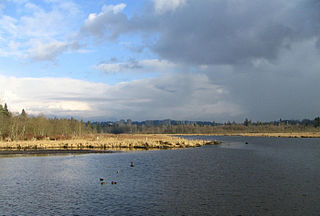
Burnaby Lake is a lake located in Burnaby, British Columbia and is the focal geographic feature and namesake of Burnaby Lake Regional Park. The lake occupies 3.11 square kilometres of land, and is home to a large variety of wildlife. At least 70 species of birds make the lake and surrounding areas their home, and about 214 species of birds visit the lake throughout the year. The park has been managed by the Metro Vancouver Parks Department since 1977.

The Gwa'Sala-Nakwaxda'xw Nations are a union of two Kwakwaka'wakw peoples in a band government based on northern Vancouver Island in British Columbia, Canada, whose main reserve community is near the town of Port Hardy in the Queen Charlotte Strait region of the Central Coast region of British Columbia, Canada. The band government is a member of the Kwakiutl District Council and, for treaty negotiation purposes, the Winalagalis Treaty Group which includes three other members of the Kwakiutl District Council.

Milbanke Sound is a sound on the coast of the Canadian province of British Columbia.

Alberni Inlet is a long, narrow inlet in Vancouver Island, British Columbia, Canada, that stretches from the Pacific Ocean at Barkley Sound about 40 km (25 mi) inland terminating at Port Alberni. It was named by the Spanish explorer Francisco de Eliza after Pedro de Alberní y Teixidor, Captain of the Free Company of Volunteers of Catalonia who was appointed in the Spanish fort in Nootka Sound from 1790 to 1792. The inlet includes traditional territories of the Ucluelet, Uchucklesaht, Huu-ay-aht, Hupacasath, and Tseshaht peoples, who are part of the Nuu-chah-nulth Tribal Council people.
Frederick Sound is a sound in the Central Coast of British Columbia, Canada. It is the largest branch of Seymour Inlet and along with that inlet was named in honour of Frederick Seymour, second governor of the Colony of British Columbia. Frederick Sound has two inlets, one named Salmon Arm and the other unnamed. The complex maze of hidden waterways forming Seymour Inlet is in the region of Queen Charlotte Strait.
Nugent Sound is a sound on the Central coast of British Columbia, Canada. It is located between Seymour Inlet to the west and Belize Inlet to the east.
Alison Sound is a sound in the Central Coast region of British Columbia, Canada. It extends north and northwest from Belize Inlet, which itself is one of the many sidewaters of Seymour Inlet. There is no connection in name or geography to Allison Harbour, which is to the southwest.
Allison Harbour, also formerly known as False Bay and False Schooner Passage, is a natural harbour on the Central Coast of British Columbia, Canada, extending north from Queen Charlotte Strait to the southeast of Bramham Island. It is the site of the former post office and steamer landing of Allison Harbour, British Columbia. The Allison Reefs lie in the entrance to the sound; Allison Cone (185m), which is nearby between Shelter Bay and Cape Caution, was named in association with Allison Harbour. It is now protected as part of Allison Harbour Marine Provincial Park.
Bramham Island is an island in the Queen Charlotte Strait region of the Central Coast of British Columbia, Canada, on the north side of the entrance to that strait. It lies in the entrance to the maze of waterways inland to the northeast, focused on Seymour Inlet, which includes Belize Inlet and Allison Harbour and Nugent Sound, though it is flanked only by Slingsby Channel on its north, and Schooner Channel on its east. To its west are the open waters at the convergence of Queen Charlotte Sound and Queen Charlotte Strait. About 23 km2 in size, it is mostly low-lying hills and has a number of freshwater lakes.
The Tottenham Range is a small mountain range in southwestern British Columbia, Canada, located between Seymour Inlet and at the head of Belize Inlet. It has an area of 46 km2 and is a subrange of the Pacific Ranges which in turn form part of the Coast Mountains.
The Nicholl Range is a small mountain range in southwestern British Columbia, Canada, located between Seymour Inlet and Belize Inlet. It has an area of 21 km2 and is a subrange of the Pacific Ranges which in turn form part of the Coast Mountains.
The Conical Range is a small mountain range in southwestern British Columbia, Canada, located between Seymour Inlet and Belize Inlet. It has an area of 13 km2 and is a subrange of the Pacific Ranges which in turn form part of the Coast Mountains.
Briggs Inlet is a fjord in the North Coast region of the Canadian province of British Columbia. It lies between the Florence and Coldwell Peninsulas. It was named by H.D. Parizeau of the Hydrographic Service after Thomas S. Briggs, a former agent with the Canadian Pacific Navigation Company. It was first charted in 1793 by Spelman Swaine, one of George Vancouver's lieutenants during his 1791-95 expedition.
Esperanza Inlet is an inlet on the West Coast of Vancouver Island in British Columbia, Canada. Its entrance is located off the northwest side of Nootka Island and is defined by a line drawn from Tachu Point to Blind Reef. Until that definition was applied by the Canadian Hydrographic Service in 1959, the inlet's entrance was considered to be the area southeast of Catala Island. Among its adjoining branches is Zeballos Inlet.
Drury inlet is an inlet in the Queen Charlotte Strait region of the Central Coast of British Columbia, Canada, extending west from Wells Passage to the northwest of North Broughton Island, northwest of the town of Port Hardy. Branching off to the northeast from the north side of the head of the inlet is Actaeon Sound.
