Vancouver Island is an island in the northeastern Pacific Ocean and part of the Canadian province of British Columbia. The island is 456 km (283 mi) in length, 100 km (62 mi) in width at its widest point, and 32,100 km2 (12,400 sq mi) in total area, while 31,285 km2 (12,079 sq mi) are of land. The island is the largest by area and the most populous along the west coasts of the Americas.

The Strait of Georgia or the Georgia Strait is an arm of the Salish Sea between Vancouver Island and the extreme southwestern mainland coast of British Columbia, Canada, and the extreme northwestern mainland coast of Washington, United States. It is approximately 240 kilometres (150 mi) long and varies in width from 20 to 58 kilometres. Along with the Strait of Juan de Fuca and Puget Sound, it is a constituent part of the Salish Sea.
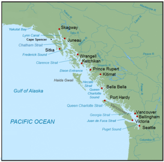
The Inside Passage is a coastal route for ships and boats along a network of passages which weave through the islands on the Pacific Northwest coast of the North American Fjordland. The route extends from southeastern Alaska in the United States, through western British Columbia in Canada, to northwestern Washington state in the United States. Ships using the route can avoid some of the bad weather in the open ocean and may visit some of the many isolated communities along the route. The Inside Passage is heavily travelled by cruise ships, freighters, tugs with tows, fishing craft, pleasure craft, and ships of the Alaska Marine Highway, BC Ferries, and Washington State Ferries systems. Coast Guard vessels of both Canada and the United States patrol and transit in the Passage.

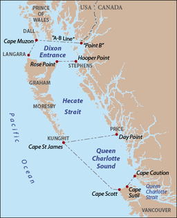
Queen Charlotte Sound is a sound of the Pacific Ocean in British Columbia, Canada, between Vancouver Island in the south and Haida Gwaii in the north. It merges with Hecate Strait in the north and Queen Charlotte Strait in the south.

The British Columbia Coast, popularly referred to as the BC Coast or simply the Coast, is a geographic region of the Canadian province of British Columbia. As the entire western continental coastline of Canada along the Pacific Ocean is in the province, it is synonymous with being the West Coast of Canada.

Knight Inlet is one of the principal inlets of the British Columbia Coast, and the largest of the major inlets in the southern part of the Coast. It is fifth in sequence of the great saltwater inlets north from the 49th parallel near Vancouver, but it is the first whose outflow points away from the Strait of Georgia, opening into Queen Charlotte Strait at the Kwakwakaʼwakw community of Memkumlis on Village Island.
Kingcome Inlet is one of the lesser principal fjords of the British Columbia Coast, north and east of Broughton Island. It is sixth in sequence of the major saltwater fjords north from the 49th parallel near Vancouver and similar in width, on average 2.5 km (1.6 mi), to longer inlets such as Knight Inlet and Bute Inlet, but it is only 35 km (22 mi) in length from the mouth of the Kingcome River to Sutlej Channel, which ultimately connects around Broughton Island to the main regional waterway of the Queen Charlotte Strait. Kingcome Inlet has a short side inlet, Wakeman Sound, fed by the Wakeman River.
Seymour Inlet is one of the lesser travelled of the principal inlets of the British Columbia Coast. Unlike larger inlets such as Knight or Bute, it is not flanked by mountains but by relatively low, but still rugged, coastal hill-country and forms a maze of complex, narrow waterways and tidal pools and lagoons. It is located within a corresponding maze of peninsulas on the mainland on the northwest side of the Queen Charlotte Strait region.

The Regional District of Mount Waddington (RDMW) is a regional district in British Columbia. It takes in the lower Central Coast region centred on the Queen Charlotte Strait coast of northern Vancouver Island and the adjoining parts of mainland British Columbia. It has a total land area of 20,288.4 km2 and a 2016 census population of 11,035 persons, most of which is in towns on Vancouver Island and adjoining islands. The administrative centre is in the town of Port McNeill. Other municipalities include the district municipality of Port Hardy, the village of Port Alice, and the village of Alert Bay.

Johnstone Strait is a 110 km (68 mi) channel along the north east coast of Vancouver Island in British Columbia, Canada. Opposite the Vancouver Island coast, running north to south, are Hanson Island, West Cracroft Island, the mainland British Columbia Coast, Hardwicke Island, West Thurlow Island and East Thurlow Island. At that point, the strait meets Discovery Passage which connects to Georgia Strait.

West Thurlow Island is an island in British Columbia, Canada. It is part of the Discovery Islands, an archipelago between Vancouver Island and the mainland, whose waters connect the Strait of Georgia with Johnstone Strait and Queen Charlotte Strait.

East Thurlow Island is an island in British Columbia, Canada. It is part of the Discovery Islands, an archipelago between Vancouver Island and the mainland, whose waters connect the Strait of Georgia with Johnstone Strait and Queen Charlotte Strait. East Thurlow Island is located north of Vancouver Island, south of the mainland, northwest of Sonora Island, and east of West Thurlow Island. East Thurlow Island is located within Electoral Area C of the Strathcona Regional District.

Price Island is an island on the coast of the Canadian province of British Columbia. It is located at the southeastern end of Hecate Strait and the northeastern end of Queen Charlotte Sound. The southernmost point of Price Island, called Day Point, is used to delineate the boundary between Hecate Strait and Queen Charlotte Sound. Milbanke Sound is just to the south of Price Island. Laredo Sound is just north. Swindle Island lies just north of Price Island. The main Inside Passage route crosses Milbanke Sound and enters Finlayson Channel just east of Price Island. Price Island is located within the Kitimat-Stikine Regional District.

Fitz Hugh Sound, sometimes spelled Fitzhugh Sound, is a sound on the British Columbia Coast of Canada, located between Calvert Island and the mainland.
Bramham Island is an island in the Queen Charlotte Strait region of the Central Coast of British Columbia, Canada, on the north side of the entrance to that strait. It lies in the entrance to the maze of waterways inland to the northeast, focused on Seymour Inlet, which includes Belize Inlet and Allison Harbour and Nugent Sound, though it is flanked only by Slingsby Channel on its north, and Schooner Channel on its east. To its west are the open waters at the convergence of Queen Charlotte Sound and Queen Charlotte Strait. About 23 km2 in size, it is mostly low-lying hills and has a number of freshwater lakes.

Seaforth Channel is a channel in the Central Coast region of the Canadian province of British Columbia which is part of the Inside Passage - the 950 miles (1,530 km) passage between Seattle, Washington and Juneau, Alaska. The marine highway goes through Seaforth Channel on the way to Milbanke Sound, one of the open sea portions of the Inland Passage. Seaforth Channel which is part of the Prince Rupert/Port Hardy BC ferry route, extends in a westerly direction from Denny Island to Milbanke Sound between Denny Island, Campbell Island and the Wright group of islands on the south. In October 2016, a Texas-owned tug/barge transiting the Canadian waters of the Inside Passage without a local pilot was hard grounded on a reef at the entrance to Seaforth Channel in October 2016. More than 100,000 L of fuel contaminated the coast, coves and shores 20 km (12 mi) west of Bella Bella, the core community of the Heiltsuk Nation as well as the environmentally sensitive Great Bear Rainforest - Canada's contribution to the Queen's Commonwealth Canopy (QCC), a network of forest conservation programs. Clean up response and salvage was criticized by the Heiltsuk, B.C. Premier Christy Clark and Prime Minister Justin Trudeau. In November in Vancouver the Prime Minister announced a $1.5B ocean protection plan to "create a marine safety system, restore marine ecosystems and undertake research into oil spill cleanup methods."

James Charles Stuart Strange was a British officer of the East India Company, one of the first maritime fur traders, a banker, and a Member of Parliament.
The Nahwitti River is a 40-kilometre (25 mi) long river in northernmost Vancouver Island, British Columbia, Canada. It flows through Cape Scott Provincial Park into Goletas Channel near Hope Island and Queen Charlotte Sound. Its watershed, 229 km2 (88 sq mi) large, is located west and northwest of Port Hardy, north and northeast of Holberg, and north of Holberg Inlet, part of Quatsino Sound.

Nahwitti was a Kwakwakaʼwakw First Nation village and a major trading site during the maritime fur trade era of approximately 1790 to 1850. Today it is an Indian reserve under the administration of the Kwakwakaʼwakw Tlatlasikwala Nation. It is located near the northern tip of Vancouver Island, at Cape Sutil on Queen Charlotte Sound, near Hope Island and the Nahwitti River, east of Cape Scott, and not far from historic Fort Rupert and modern Port Hardy.
Cape Sutil is the headland at the northernmost point of Vancouver Island, in the Canadian Province of British Columbia.