
Galiano Island is one of the Southern Gulf Islands located between Vancouver Island and the Lower Mainland of British Columbia, Canada. Located on the west side of the Strait of Georgia, the island is bordered by Mayne Island to the southeast, Salt Spring Island to the west and Valdes Island to the northwest. Galiano is part of the Capital Regional District Electoral Area G, and has a permanent population of 1,396 inhabitants as of 2021.

Queen Charlotte Sound is a sound of the Pacific Ocean in British Columbia, Canada, between Vancouver Island in the south and Haida Gwaii in the north. It merges with Hecate Strait in the north and Queen Charlotte Strait in the south.

Queen Charlotte Strait is a strait between Vancouver Island and the mainland of British Columbia, Canada. It connects Queen Charlotte Sound with Johnstone Strait and Discovery Passage and via them to the Strait of Georgia and Puget Sound. It forms part of the Inside Passage from Washington to Alaska. The term Queen Charlotte Strait is also used to refer to the general region and its many communities, notably of the Kwakwakaʼwakw peoples. Despite its name, Queen Charlotte Strait does not lie between Haida Gwaii and the mainland; that body of water is named Hecate Strait.
Bartolomé Ferrer, also known as Bartolomé Ferrelo, was born in 1499 in the region of Levante, Spain, or in Bilbao, Biscay, and died in 1550 in Mexico.

Knight Inlet is one of the principal inlets of the British Columbia Coast, and the largest of the major inlets in the southern part of the Coast. It is fifth in sequence of the great saltwater inlets north from the 49th parallel near Vancouver, but it is the first whose outflow points away from the Strait of Georgia, opening into Queen Charlotte Strait at the Kwakwakaʼwakw community of Memkumlis on Village Island.
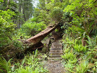
Cape Scott Provincial Park extends from Shushartie in the east, then westward around Cape Scott and south to San Josef Bay. This coastline comprises the northern tip of Vancouver Island, British Columbia. The 22,294-hectare (55,090-acre) provincial park is about 563 km (350 mi) northwest of Victoria.

Dionisio Alcalá Galiano was a Spanish naval officer, cartographer, and explorer. He mapped various coastlines in Europe and the Americas with unprecedented accuracy using new technology such as chronometers. He commanded an expedition that explored and mapped the Strait of Juan de Fuca and the Strait of Georgia, and made the first European circumnavigation of Vancouver Island. He reached the rank of brigadier and died during the Battle of Trafalgar.

Cortes Island is an island in the Discovery Islands archipelago on the coast of British Columbia, Canada. The island is 25 km (16 mi) long, 13 km (8 mi) wide, and 130 km2 (50 sq mi) in area. It has a population of 1,035 permanent residents. Cortes Island lies within Electoral Area B of the Strathcona Regional District, which provides water and sewage systems, fire protection, land use planning, parks, recreation, and emergency response.

Cayetano Valdés y Flores Bazán (1767–1835) was a commander of the Spanish Navy, explorer, and captain general who served in the French Revolutionary and Napoleonic Wars, fighting for both sides at different times due to the changing fortunes of Spain in the conflict. He took part in a number of naval battles, including the Great Siege of Gibraltar, the Battle of Cape St Vincent, and the Battle of Trafalgar. He was an explorer, most notable in the Pacific Northwest, where he and Dionisio Alcalá Galiano conducted the first circumnavigation of Vancouver Island, in partial cooperation with George Vancouver. Over his long career he achieved the highest ranks in the Spanish Navy, eventually being named Captain General of Cadiz and Captain General of the Spanish Navy.

Valdes Island is one of the Gulf Islands located in the Strait of Georgia, British Columbia, Canada. It is across Porlier Pass from Galiano Island, which lies to the southeast. It has an area of 23 square kilometres, and is 1.6 kilometres wide by 16 kilometres in length. The island is popular with kayakers, boaters and has historically been the site of several human settlements.

West Redonda Island is an island in British Columbia, Canada. It is part of the Discovery Islands, an archipelago between Vancouver Island and the mainland, and between the Strait of Georgia and Johnstone Strait.
Cordero Channel is a strait in British Columbia, Canada, located between the mainland and Vancouver Island, among the Discovery Islands north of the Strait of Georgia. Cordero Channel runs north of Sonora Island, East Thurlow Island, and part of West Thurlow Island. Its eastern end connects to the mouth of Bute Inlet and to Calm Channel, at Stuart Island. Its west end is marked by the mouth of Loughborough Inlet, beyond which the channel is called Chancellor Channel, which continues west to Johnstone Strait.

José Cardero was a Spanish draughtsman and artist. He is most remembered for his work on the expedition of Alejandro Malaspina and the related expedition of Dionisio Alcalá Galiano. During the Galiano voyage Cordero Channel was named in his honor. Other places in British Columbia were later named in his honor as well, including Dibuxante Point, "dibuxante" being Spanish for "draughtsman".
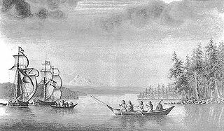
Sutil was a brig-rigged schooner built in 1791 by the Spanish Navy at San Blas, New Spain. It was nearly identical to Mexicana, also built at San Blas in 1791. Both vessels were built for exploring the newly discovered Strait of Georgia, carried out in 1792 under Dionisio Alcalá Galiano, on Sutil, and Cayetano Valdés y Flores, on Mexicana. During this voyage the two Spanish vessels encountered the two British vessels under George Vancouver, HMS Discovery and HMS Chatham, which were also engaged in exploring the Strait of Georgia. The two expeditions cooperated in surveying the complex channels between the Strait of Georgia and Queen Charlotte Strait, in the process proving the insularity of Vancouver Island. After this first voyage Sutil continued to serve the San Blas Naval Department, making various voyages to Alta California and the Pacific Northwest coast.
The Mexicana was a topsail schooner built in 1791 by the Spanish Navy at San Blas, New Spain. It was nearly identical to the Sutil, also built at San Blas later in 1791. Both vessels were built for exploring the newly discovered Strait of Georgia, carried out in 1792 under Dionisio Alcalá Galiano, on the Sutil, and Cayetano Valdés y Flores, on the Mexicana. During this voyage the two Spanish vessels encountered the two British vessels under George Vancouver, HMS Discovery and Chatham, which were also engaged in exploring the Strait of Georgia. The two expeditions cooperated in surveying the complex channels between the Strait of Georgia and Queen Charlotte Strait, in the process proving the insularity of Vancouver Island. After this first voyage the Mexicana continued to serve the San Blas Naval Department, making various voyages to Alta California and the Pacific Northwest coast.

The Descubierta and Atrevida were twin corvettes of the Spanish Navy, custom-designed as identical special exploration and scientific research vessels. They were built at the same time for the Malaspina Expedition. Under the command of Alejandro Malaspina (Descubierta) and José de Bustamante y Guerra (Atrevida) the two vessels sailed from Spain to the Pacific Ocean, conducting a thorough examination of the internal politics of the American Spanish Empire and the Philippines. They explored the coast of Alaska and worked to reinforce Spain's claim to the Pacific Northwest in the aftermath of the Nootka Crisis. After crossing the Pacific Ocean, the colonial government in the Philippines was examined. Exploration and diplomatic reconnaissance followed, with stops in Qing dynasty-era China, New Zealand, Australia, and Tonga.
The Nahwitti River is a 40-kilometre (25 mi) long river in northernmost Vancouver Island, British Columbia, Canada. It flows through Cape Scott Provincial Park into Goletas Channel near Hope Island and Queen Charlotte Sound. Its watershed, 229 km2 (88 sq mi) large, is located west and northwest of Port Hardy, north and northeast of Holberg, and north of Holberg Inlet, part of Quatsino Sound.

Nahwitti was a Kwakwakaʼwakw First Nation village and a major trading site during the maritime fur trade era of approximately 1790 to 1850. Today it is an Indian reserve under the administration of the Kwakwakaʼwakw Tlatlasikwala Nation. It is located near the northern tip of Vancouver Island, at Cape Sutil on Queen Charlotte Sound, near Hope Island and the Nahwitti River, east of Cape Scott, and not far from historic Fort Rupert and modern Port Hardy.
Goletas Channel is a channel and strait on the north side of Vancouver Island in British Columbia, Canada. It separates Vancouver Island from Hope Island and Nigei Island, located just east of Cape Sutil, the northernmost point of Vancouver Island. The waters of Goletas Channel are part of northern Queen Charlotte Strait.
San Josef Bay is a bay on the northwest coast of Vancouver Island, in the province of British Columbia, Canada.
