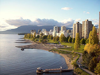
English Bay is an open bay northwest of the Burrard Peninsula in British Columbia, Canada, extending from the headland between Siwash Rock and Prospect Point on Vancouver's Downtown peninsula in the northeast, to the northwestern tip of Point Grey in the southwest. The bay encompasses the coasts of Stanley Park, the West End, Kitsilano, West Point Grey and the University Endowment Lands, and makes up the southeastern portion of the Outer Burrard Inlet. There is a narrow inlet named False Creek at its eastern end.

Parts of this article have been adapted from the BC Parks website.

Big Bunsby Marine Provincial Park is a provincial park on the west coast of northern Vancouver Island in British Columbia, Canada, to the southeast of the Brooks Peninsula in Checleset Bay. It is accessible only by boat.
Cape Scott Provincial Park extends from Shushartie in the east, then westward around Cape Scott and south to San Josef Bay. This coastline comprises the northern tip of Vancouver Island, British Columbia. The 22,294-hectare (55,090-acre) provincial park is about 563 km (350 mi) northwest of Victoria.

Vargas Island Provincial Park is a provincial park in British Columbia, Canada, comprising the west side of the island of the same name, which is located west of Meares Island and northwest of the resort community of Tofino in the Clayoquot Sound region of the West Coast of Vancouver Island, British Columbia, Canada. The park was created as part of the Clayoquot Land-Use Decision on July 13, 1995 and contains 5,805 hectares, 1,543 hectares of it being upland and 4,262 hectares being foreshore. Also located on Vargas Island, on its north side, is Epper Passage Provincial Park.
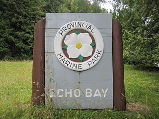
Echo Bay Marine Provincial Park is a provincial park in British Columbia, Canada, established in 1971 and containing 1.5 hectares. It is located at the bay of the same name, offshore from the community of the same name, which is the location of the Simoom Sound post office and is on the west side of Gilford Island.

Say Nuth Khaw Yum Provincial Park, also known as Indian Arm Park, is a provincial park located in the Lower Mainland of British Columbia, Canada. The park was established on July 13, 1995 by BC Parks to protect the forested mountain terrain of Indian Arm.
Memory Island Provincial Park is a provincial park located on Vancouver Island in British Columbia, Canada. It was established by BC Parks on 23 August 1945 to protect a small island located at the southern end of Shawnigan Lake.

The Purcell Wilderness Conservancy is a provincial park in British Columbia, Canada. It was established in 1974, and encompasses six large drainages in the Purcell Mountains in the southeast of the province. It contains high peaks, alpine meadows and ridges, deep creek and river valleys, and hot springs at Dewar Creek.

Shannon Falls Provincial Park is a provincial park in British Columbia, Canada. It is located 58 kilometers (36 mi) from Vancouver and 2 kilometers (1.2 mi) south of Squamish along the Sea to Sky Highway.

BC Parks is an agency of the British Columbia Ministry of Environment and Climate Change Strategy that manages all of the, as of 2020, 1,035 provincial parks and other conservation and historical properties of various title designations within the province's Parks oversaw of the British Columbia Parks and Protected Areas System. The Lieutenant Governor-in-Council created the agency on March 1, 1911, through the Strathcona Park Act. The agency is charged with a dual role of preserving the ecological and historical integrity of the places entrusted to its management, while also making them available and accessible for public use and enjoyment.
Blunden Harbour is a small harbour and native Indian reserve in the Canadian province of British Columbia. It is located the mainland side of Queen Charlotte Strait about 25 kilometres (16 mi) northeast of Port Hardy. Blunden Harbour was the location of a Kwakwaka'wakw village, whose residents referred to themselves as the 'Nak'waxda'xw and are known historically as the Nakoaktok.

Cape Scott Lighthouse is at the northwestern extremity of Vancouver Island, British Columbia.
Kamano Island is an island in the Queen Charlotte Strait-Johnstone Strait region of the Central Coast of British Columbia, located east of Harbledown Island and between Turnour Island (N) and Village Island (S).
Drury inlet is an inlet in the Queen Charlotte Strait region of the Central Coast of British Columbia, Canada, extending west from Wells Passage to the northwest of North Broughton Island, northwest of the town of Port Hardy. Branching off to the northeast from the north side of the head of the inlet is Actaeon Sound.
Scott Islands Marine National Wildlife Area is a National Wildlife Area off the northwestern tip of Vancouver Island in British Columbia, Canada. Covering an area of 11,570.65 km (7,189.67 mi), it is the second largest protected area in British Columbia after Offshore Pacific Seamounts and Vents Closure and is the largest national wildlife area in Canada.

The Burdwood Group Conservancy is a conservancy located in the Broughton Archipelago in Mount Waddington Regional District, British Columbia. It was established by BC Parks on 13 March 2009 to protect a unique cluster of forested islands and islets situated at the entrance to Tribune Channel.
Neʼāhʼ Conservancy is a conservancy located in the Stikine Region of British Columbia, Canada. The conservancy was established on 31 March 2013 through a cooperative resource management and land use planning agreement between BC Parks and the Kaska Dena First Nations.
Duu Guusd Heritage Site/Conservancy is a heritage site and conservancy located in the northwest corner of Graham Island in the Haida Gwaii archipelago of British Columbia, Canada. It was established on March 23, 2008 to protect the ecological integrity and cultural importance of the region. The conservancy is part of an archipelago-wide system of protected areas that includes Gwaii Haanas National Park Reserve and Haida Heritage Site, Gwaii Haanas National Marine Conservation Area Reserve and Haida Heritage Site, and 17 other provincially protected areas.
Taku River/T'aḵú Téiú' Conservancy is a conservancy located in the Stikine Region of British Columbia, Canada. It was established on June 22, 2012, as a result of the Wóoshtin Wudidaa Atlin Taku Land Use Plan and Taku River Tlingit First Nation Strategic Engagement Agreement. The conservancy protects a large region of pristine wilderness along the Taku River from its confluence with the Nakina and Inklin Rivers to the Alaska-British Columbia border.
