
Haida Gwaii is an archipelago located between 55–125 km (34–78 mi) off the northern Pacific coast of Canada. The islands are separated from the mainland to the east by the shallow Hecate Strait. Queen Charlotte Sound lies to the south, with Vancouver Island beyond. To the north, the disputed Dixon Entrance separates Haida Gwaii from the Alexander Archipelago in the U.S. state of Alaska.
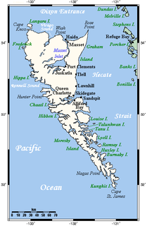
Graham Island is the largest island in the Haida Gwaii archipelago, lying off the coast of British Columbia, Canada. It is separated only by a narrow channel from the other principal island of the group, Moresby Island. It has a population of 4,475, an area of 6,361 km2 (2,456 sq mi), and is the 101st largest island in the world and Canada's 22nd largest island.

Hecate Strait is a wide but shallow strait between Haida Gwaii and the mainland of British Columbia, Canada. It merges with Queen Charlotte Sound to the south and Dixon Entrance to the north. About 140 kilometres (87 mi) wide at its southern end, Hecate Strait narrows in the north to about 48 kilometres (30 mi). It is about 260 kilometres (160 mi) in length.

Burrard Inlet is a relatively shallow-sided coastal fjord in southwestern British Columbia, Canada. Formed during the last Ice Age, it separates the City of Vancouver and the rest of the low-lying Burrard Peninsula from the slopes of the North Shore Mountains, home to the communities of West Vancouver and the City and District of North Vancouver.

The British Columbia Coast, popularly referred to as the BC Coast or simply the Coast, is a geographic region of the Canadian province of British Columbia. It is synonymous with being the West Coast of Canada, including the entire western continental coastline of Canada along the Pacific Ocean.

Knight Inlet is one of the principal inlets of the British Columbia Coast, and the largest of the major inlets in the southern part of the Coast. It is fifth in sequence of the great saltwater inlets north from the 49th parallel near Vancouver, but it is the first whose outflow points away from the Strait of Georgia, opening into Queen Charlotte Strait at the Kwakwakaʼwakw community of Memkumlis on Village Island.

Skidegate is a Haida community in Haida Gwaii in British Columbia, Canada. It is located on the southeast coast of Graham Island, the largest island in the archipelago, and is approximately 50 kilometres (31 mi) west of mainland British Columbia across Hecate Strait.

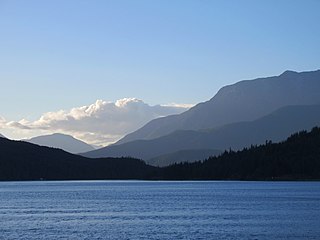
The Village of Queen Charlotte, more commonly known by its residents as Charlotte, is a village municipality on Haida Gwaii in the province of British Columbia, Canada. It is located on the southern end of Graham Island at Skidegate Inlet and is a member municipality of the North Coast Regional District.

The Salish Sea is a marginal sea of the Pacific Ocean located in the Canadian province of British Columbia and the U.S. state of Washington. It includes the Strait of Georgia, Strait of Juan de Fuca, Puget Sound, and an intricate network of connecting channels and adjoining waterways.
Broughton Archipelago is a group of islands located at the eastern end of Queen Charlotte Strait in Mount Waddington Regional District, British Columbia. The archipelago is the traditional territory of the Musgamagw Dzawada'enuxw, Namgis, Ma'amtagila and Tlowitsis nations of the Kwakwaka'wakw peoples.

Calvert Island is an island on the coast of the Canadian province of British Columbia. It is located east of Queen Charlotte Sound in the Central Coast region, about 100 kilometres (62 mi) north of the town of Port Hardy, which is at the north end of Vancouver Island.
Quatsino Sound is a complex of coastal inlets, bays and islands on northwestern Vancouver Island in the Canadian province of British Columbia. It is the northernmost of the five sounds that pierce the west coast of Vancouver Island, the others being Kyuquot Sound, Nootka Sound, Clayoquot Sound, and Barkley Sound.
The Yakoun River is the largest river on Haida Gwaii, off the North Coast of British Columbia, Canada. Estimated to be 55 to 60 kilometres in length, it is located on Graham Island, the northernmost and largest of the archipelago, and runs in a twisting course generally northwards from Yakoun Lake, which lies near the island's south-central region, just northwards over Slatechuck Mountain from Skidegate Inlet, entering saltwater at Masset Inlet, a large saltwater bay located in the heart of the island.
The Skidegate Band Council, also known as the Skidegate First Nation, is a band government of the Haida people, one of two of the Haida Tribal Society aka the Council of the Haida Nation. Its offices are located in Skidegate, British Columbia.

Trincomali Channel is a channel located in the Gulf Islands of British Columbia, Canada.

Skidegate Inlet is a broad inlet on the east coast of the Haida Gwaii archipelago of the North Coast of British Columbia, Canada. It is the easternmost of a series of waterways separating Graham Island to the north from Moresby Island to the south.

Hardy Island is an island of the Northern Gulf Islands archipelago located in the Sunshine Coast region of British Columbia.
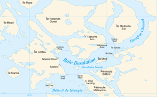
Homfray Channel is a deep water channel located between East Redonda and the mainland coast of British Columbia, Canada.
Calm Channel is a channel located between several major islands of the Discovery Islands in British Columbia, Canada. The channel is an important waterway for boats transiting the archipelago.

