Related Research Articles

Goshen Township is a township in Clearfield County, Pennsylvania, United States. The population was 393 at the 2020 census.

Princess Royal Island is the largest island on the North Coast of British Columbia, Canada. It is located amongst the isolated inlets and islands east of Hecate Strait on the British Columbia Coast. At 2,251 square kilometres (869 sq mi), it is the fourth largest island in British Columbia. It was named in 1788 by Captain Charles Duncan, after his ship Princess Royal.
Pyramid Creek Falls Provincial Park is a provincial park in British Columbia, Canada, located on the east side of the North Thompson River between the towns of Blue River (S) and Valemount (N).
Shuswap Lake Marine Provincial Park is a provincial park in British Columbia, Canada, comprising 894 ha. The Park has a variety of amenities including boat launch ramps, picnic areas, and 27 campsites around the perimeter of Shuswap Lake. The lake's name and that of the surrounding Shuswap Country is from the Shuswap people (Secwepemc), the most northern of the Salishan speaking people.
The Williams Lake First Nation is a First Nations government of the Secwepemc (Shuswap) Nation, located in the Cariboo region of the Central Interior region of the Canadian province of British Columbia, at the city of Williams Lake. It was created when the government of the then-Colony of British Columbia established an Indian reserve system in the 1860s. It is a member government of the Northern Shuswap Tribal Council. Its main Indian Reserve is Williams Lake Indian Reserve No. 1, a.k.a. "Sugarcane" or "The Cane" or "SCB".
Wulgai is a village in Pishin District, Balochistan province, Pakistan. It lies on the Wulgai formation - the land containing shale and limestone formations.
Singai is a town located in Sarawak, Malaysia. It is located several kilometers southwest of Kuching.

Paddock Hills is one of the 52 neighborhoods of Cincinnati, Ohio. The population was 1,038 at the 2020 census.
Juan Perez Sound is a sound off the east coast of Moresby Island in the Queen Charlotte Islands of British Columbia, Canada. It is named for Juan José Pérez Hernández, usually known as Juan Pérez, who was among the first European explorers in the region.

Fimbulheimen is a mountain range in Queen Maud Land, Antarctica. It stretches from Jutulstraumen by 1° west of Carsten Borchgrevink Ice at 18° east, about 200 km from the ice edge. Fimbulheimen is thus between Maudheim Plateau and Sør-Rondane.
Dinjan is a small township in Dibrugarh district of Assam, India. It is located in the tea growing area of Assam. The closest town to it is Tinsukia. During World War II, nearby Dinjan Airfield was used by transport aircraft which carried supplies over The Hump to Kunming, China for the Chinese army.
Tagriss is a village and rural commune in Niger.

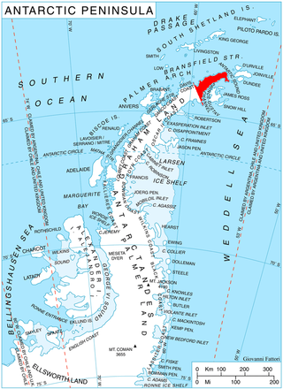
Sestrimo Glacier is the 11 km long and 4 km wide glacier on the northwest side of Trinity Peninsula in Graham Land on the Antarctic Peninsula. Situated southwest of Ogoya Glacier, west-northwest of Broad Valley and north of Cugnot Ice Piedmont. Draining the north slopes of Windy Gap, and flowing northwards east of Mount D'Urville and west of Argentino (Guerrero) Peak to enter Lafond Bay in Bransfield Strait south of Cockerell Peninsula.
Susan Island is an island in the North Coast of British Columbia, Canada. To its west is Finlayson Channel; to its east Mathieson Channel. Roderick Island lies to its north and Dowager Island to its south. James Johnstone, one of George Vancouver's lieutenants during his 1791-95 expedition, first charted its west and east coasts in 1793.

Mathieson Channel is a channel of the British Columbia Coast. It is a northern extension of Milbanke Sound. To its west are Pooley, Roderick, Susan and Dowager Islands, to its east the Don Peninsula. It was first charted in 1793 by James Johnstone, one of George Vancouver's lieutenants during his 1791-95 expedition.
Spiller Channel is a channel of the British Columbia Coast. It separates the Don Peninsula from Yeo Island. It was first charted in 1793 by James Johnstone, one of George Vancouver's lieutenants during his 1791–95 expedition.
Yeo Island is an island in the North Coast region of British Columbia, Canada. It is separated from the Don Peninsula to its west by Spiller Channel, and from the Coldwell Peninsula to its east by Bullock Channel. It was first charted and circumnavigated in 1793 by James Johnstone, one of George Vancouver's lieutenants during his 1791–95 expedition.
Sarah Island is an island in the North Coast of British Columbia, Canada. It is separated from Princess Royal Island to its west by Tolmie Channel, and from Roderick Island to its east by Finlayson Channel. Its east coast was first charted in 1793 by James Johnstone, one of George Vancouver's lieutenants during his 1791-95 expedition.
The Cassiar Land District is a cadastral survey subdivision of the province of British Columbia, Canada, created with rest of those on Mainland British Columbia via the Lands Act of the Colony of British Columbia in 1860. The British Columbia government's BC Names system, a subdivision of GeoBC, defines a land district as "a territorial division with legally defined boundaries for administrative purposes". All land titles and surveys use the Land District system as the primary point of reference, and entries in BC Names for placenames and geographical objects are so listed.
The Lillooet Land District is one of the 59 cadastral subdivisions of British Columbia, which were created by the Lands Act of the Colony of British Columbia in 1859, defined as "a territorial division with legally defined boundaries for administrative purposes". The land district's boundaries came to be used as the boundary of the initial Lillooet riding for the provincial Legislature from 1871, when the colony became a province. In addition to use in descriptions of land titles and lot surveys, the Land District was also the basis of the Lillooet Mining District.
References
52°30′00″N128°10′00″W / 52.50000°N 128.16667°W