External links
55°15′N127°40′W / 55.250°N 127.667°W
| | This article about a location in the Interior of British Columbia, Canada is a stub. You can help Wikipedia by expanding it. |
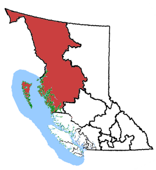
The Skeena Country is a historic geographic region comprising areas of both the British Columbia Coast and the British Columbia Interior in northwestern British Columbia, Canada.
55°15′N127°40′W / 55.250°N 127.667°W
| | This article about a location in the Interior of British Columbia, Canada is a stub. You can help Wikipedia by expanding it. |

Cariboo—Prince George is a federal electoral district in the province of British Columbia, Canada, that has been represented in the House of Commons of Canada since 2004.
Skeena—Bulkley Valley is a federal electoral district in British Columbia, Canada, that has been represented in the House of Commons of Canada since 2004.
Comox—Atlin was a federal electoral district in the province of British Columbia, Canada, that was represented in the House of Commons of Canada from 1904 to 1917.
Skeena was a federal electoral district in British Columbia, Canada, that was represented in the House of Commons of Canada from 1917 to 2004.
Cariboo—Chilcotin was a federal electoral district in British Columbia, Canada, that was represented in the House of Commons from 1979 to 2003.
Prince George—Bulkley Valley was a federal electoral district in British Columbia, Canada, that was represented in the House of Commons of Canada from 1979 to 2004.

Skeena is a provincial electoral district for the Legislative Assembly of British Columbia, Canada. It first appeared in the provincial election of 1924. It should not be confused with the former federal electoral district of Skeena, which encompassed a larger area.
Bulkley Junction Provincial Park is a provincial park in British Columbia, Canada, located on the west side of the Skeena River opposite Hazelton. It was established in 1997 and expanded in 2004 from 133 ha. to its current size of 169 ha.

Moresby Island is a large island that forms part of the Haida Gwaii archipelago in British Columbia, Canada, located at 52°45′00″N131°50′00″W. It is separated by the narrow Skidegate Channel from the other principal island of the group to the north, Graham Island.
The Stikine Ranges are a group of mountain ranges and mountainous plateaus in northwestern British Columbia, Canada. They are the northernmost subdivision of the Cassiar Mountains and among the least explored and most undeveloped parts of the province.
Gitsegukla is a Gitxsan community of about 500 at the confluence of the Kitseguecla and Skeena Rivers, approximately 40 km southwest of Hazelton, British Columbia, Canada. The community is on Gitsegukla Indian Reserve No. 1.

Kispiox is a Gitxsan village of approximately 550 in the Kispiox Valley, at the confluence of the Kispiox and Skeena Rivers in British Columbia. Located 13 km (8 mi) north of Hazelton, the community is situated within the Kispiox Indian reserve and is managed by the Kispiox Band Council.
Skeena may refer to:
Hagwilget Canyon is a canyon on the Bulkley River of northwestern British Columbia, Canada, located several kilometres upstream from that river's confluence with the Skeena River at Hazelton, at the Wet'suwet'en village of Hagwilget.

ʼKsan is a historical village and living museum of the Gitxsan Indigenous people in the Skeena Country of Northwestern British Columbia, Canada. ʼKsan is located near Hazelton at the confluence of the Skeena and Bulkley Rivers on Gitxsan territory.
Glen Vowell is an Indian reserve community of the Gitxsan people in the Hazelton area of the Skeena Country of northwestern British Columbia, Canada. It is located on the west side of the Skeena River between Hazelton and Kispiox. Its traditional name is Sik i dak, which has also been spelled Sikadoak and is reflected in the name of the reserve, Sik-e-dakh IR 2. Also nearby is another Indian reserve, Anlaw Indian Reserve No. 4. The band government of the reserve is the Glen Vowell Indian Band, which also goes by the name Sik-e-Dakh.
The Oweegee Range is a small subrange of the Skeena Mountains of the Interior Mountains, located on the east side of Bell-Irving River in northern British Columbia, Canada.
The Takla Range is a small subrange of the Skeena Mountains of the Interior Mountains, bounded by Takla Lake and Northwest Arm in northern British Columbia, Canada.
The Sustut River is a major tributary of the Skeena River in the north-central Interior of British Columbia, Canada. It forms the northwest boundary of the Hogem Ranges and flows southwest to meet the Skeena, north of Hazelton. Originally named the Bear Wallow River, its headwaters are at Sustut Lake, northwest of Germansen Landing.
The Kispiox River is a river in the Skeena Country of British Columbia, Canada. It is a tributary of the Skeena River, flowing southeast to meet that river above its confluence with the Bulkley near Hazelton. It forms the eastern boundary of the Kispiox Range subdivision of the Hazelton Mountains.