Gulf Islands

Last updated

Gulf Islands
View from Baynes Peak, Saltspring Island, British Columbia, Canada 04.jpg
Gulf Islands
Geography
Location Salish Sea
Coordinates 48°57′N123°32′W / 48.950°N 123.533°W / 48.950; -123.533
Major islands20
Administration
Province British Columbia
Demographics
Population23,497 (2016 est.)

The Gulf Islands is a group of islands in the Salish Sea between Vancouver Island and the mainland coast of British Columbia.

Contents

Etymology

The name "Gulf Islands" comes from "Gulf of Georgia", the original term used by George Vancouver in his mapping of the southern part of the archipelago and which before the San Juan Island dispute also was taken to include what have since been called the San Juan Islands.[ citation needed ] While geopolitically divided, the San Juan Islands and Gulf Islands geologically form part of the larger Gulf Archipelago. [1]

Strictly speaking, the Strait of Georgia is only the wide, open waters of the main strait between the mainland and Vancouver Island, and does not officially refer to the adjoining waters between the islands and Vancouver Island but has become a common misnomer for the entire Gulf, which includes waters such as Active Pass (between Galiano Island and Mayne Island), Trincomali Channel (between Galiano Island and Saltspring Island), Sansum Narrows (between Saltspring Island and Vancouver Island), and Malaspina Strait (between Texada Island and the mainland around Powell River). "The Gulf" refers to all such waters collectively, and to those communities and shores surrounding it. [2] Only the term "Strait of Georgia" remains in the provincial gazette although its use as a synonym for the Gulf is unofficial, while the term Gulf of Georgia remains in current use though not in the provincial gazette.

The term Salish Sea was adopted in 2010 to refer to the Strait of Georgia, the Strait of Juan de Fuca, Puget Sound, and all connecting and adjoining waters. [3]

Boundaries

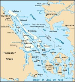
According to BC Geographical Names (BCGNIS) the name "Gulf Islands" was originally intended and commonly understood to refer to the archipelago at the southern end of the Strait of Georgia; from Gabriola Island in the north to Saturna Island in the southeast and D'Arcy Island in the southwest. During the 1990s, however, the name began to be applied to all the islands in the Strait of Georgia, resulting in the introduction of the term "Southern Gulf Islands", which BCGNIS calls a misnomer, to distinguish the original "Gulf Islands" from the rest, which are sometimes called the "Northern Gulf Islands". BCGNIS further notes that Quadra Island is increasingly described as the "northernmost of the Gulf Islands". [4]

Island groups

The division of the Gulf Islands into two groups, the Southern and Northern Gulf Islands, is relatively common. The dividing line is approximately that formed by the city of Nanaimo on Vancouver Island, and the mouth of the Fraser River on the mainland. The islands of the Discovery Islands, Howe Sound, and Fraser River delta are not considered part of the Gulf Islands.

Southern Gulf Islands

Southern Gulf Islands (highlighted) Gulf Islands map 2.png
Southern Gulf Islands (highlighted)

The Southern Gulf Islands are near the southern end of the Strait of Georgia, forming an intricate network of waterways between them, collectively referred to as part of the Salish Sea. The Southern Gulf Islands include hundreds of islands and islets, and form part of a larger archipelago that also includes the nearby San Juan Islands of the state of Washington in the United States.

The major Southern Gulf Islands are:

Island Regional district Area (km2)PopulationDensity (per km2)
Gabriola Nanaimo 57.64,500 [5] 78.1
Galiano Capital 60.151,39617.4
Mayne Capital 211,30451
Moresby Capital 8.3430.4
Pender Capital 342,46766.0
Penelakut Cowichan Valley 8.6630234.9
Prevost Capital 6.75 ? ?
Salt Spring Capital 182.711,635 [6] 63.7
Saturna Capital 3146511.3
Sidney Capital 8.66 ? ?
Thetis Cowichan Valley 10.3647633.8
Valdes Cowichan Valley 23100.4

Northern Gulf Islands

Texada Island (highlighted) and the surrounding Northern Gulf Islands Locmap-Texada2.png
Texada Island (highlighted) and the surrounding Northern Gulf Islands

The Northern Gulf Islands are located near the northern end of the Strait of Georgia, including all islands south of Savary Island, the southernmost island of the neighbouring Discovery Islands.

The major Northern Gulf Islands are as follows:

Island Regional district Area (km2)PopulationDensity (per km2)
Ahgykson qathet 9.2500
Denman Comox Valley 51.031,16522.8
Hardy Sunshine Coast 7.25 ? ?
Hornby Comox Valley 29.9795832.0
Lasqueti qathet 73.323995.4
Nelson Sunshine Coast 102.8 ? ?
Texada qathet 300.451,0533.5
Thormanby Sunshine Coast 8.65 ? ?

Ecology

Arbutus trees and sandstone beaches are common in the Gulf Islands. Arbutus sandstone.JPG
Arbutus trees and sandstone beaches are common in the Gulf Islands.

The islands and surrounding ocean are rich with ecologically diverse plants and sea life including Garry oaks, wild lilies, kelp beds and Orcas.

The Gulf Islands are home to one of the last remaining pockets of Garry oak ecosystems. Only about five percent of Garry oak ecosystems remain in their natural state, landing 91 of the approximately 350 species it supports on the province's list of species at risk. The unique Mediterranean characteristics of the islands' climate supports the Garry oak ecosystem. Garry oak ecosystems are home to more plant species, such as the camas, than any other terrestrial ecosystem in coastal B.C. and are one of Canada's most at-risk natural habitats.

Today, Garry oak meadows exist in the shallow and exposed soil of valleys, rocky foothills and southern slopes—areas that the settlers of the past 150 years have found unsuitable for agriculture or development.

The Garry Oak Ecosystems Recovery Team (GOERT), a partnership of a number of governmental and non-governmental agencies that comprise 22 individuals, was established in 1999 after the delegates of the First International Garry Oak Ecosystem Symposium met in Victoria and declared the ecosystem endangered. Since then, GOERT has been working to motivate public and private restoration of the rare ecosystem and promote conservation activities.

Conservation

The unique ecosystem of the islands has been a focal point of conservation efforts for decades. BC Parks operates a variety of provincial parks on the islands, the oldest being Mount Maxwell Provincial Park on Salt Spring Island.

In 2003, Parks Canada established Gulf Islands National Park Reserve to protect ecologically important regions of the southeastern Gulf Islands. As a National Park Reserve, the long-term goal is to protect most of the southeastern Gulf Islands. [7]

In 2012, Parks Canada published a feasibility Study for the proposed Southern Strait of Georgia National Marine Conservation Area Reserve. The goal of the National Marine Conservation Area is to protect ecologically significant marine habitats and ensure sustainable use of marine resources. It would also serve as a complement to the existing national park reserve. [8]

Agriculture

Grove positioned on a downward slope, creating a natural drainage system. Sea and olives.jpg
Grove positioned on a downward slope, creating a natural drainage system.

In most parts of Canada, olive trees cannot thrive; the long, harsh winter and short, humid summer and spring make it difficult for olives to grow comfortably and properly, but Pender Island, Saturna Island, and Salt Spring Island have a Mediterranean style climate that permits olive production. [9] [10]

Banana Joe Clemente was one of the first Islanders to introduce olive trees to the Southern Gulf Islands in 1993 growing dozens from seed. In 1994/1995, planting a grove of the seed-grown olive trees around a Botchi pit on Salt Spring Island. He also distributed them to Islanders for their private gardens. Banana Joe is also responsible for introducing Musa basjoo, a hardy species of Banana plant to Salt Spring Island.

Farm owner Andrew Butt planted his first olive tree in 2001 at his farm on Pender Island, using Frantoio and Leccino cultivars that he obtained from California. [10] He uses kelp obtained from the surrounding straits as fertilizer and uses a pruning method that enhances the sunlight exposure on the trees. [10] Michael Pierce and colleagues established an olive tree nursery on Saturna Island in 2009 that supplied olive trees to the region. [11]

Transportation

The larger populated islands are served by BC Ferries, which operates various vehicle and passenger ferries between the Gulf Islands and to terminals near the major cities of Nanaimo and Victoria on Vancouver Island as well as Vancouver on the mainland.

None of the islands are linked to another island by bridge, the exception being Pender Island which was artificially divided into two by a canal dug in 1903. Various proposals have been made to link one or more of the islands to another island, or with the mainland coast of the province, without success. Challenges include high capital costs, the presence of ecologically sensitive ecosystems, the mountainous terrain of the islands, impracticality due to the low population of the islands, and opposition from locals. [12] [13]

See also

Related Research Articles

<span class="mw-page-title-main">San Juan Islands</span> Archipelago in the Salish Sea in Washington, US

The San Juan Islands is an archipelago in the Pacific Northwest of the United States between the U.S. state of Washington and Vancouver Island, British Columbia, Canada. The San Juan Islands are part of Washington state, and form the core of San Juan County.

<span class="mw-page-title-main">Vancouver Island</span> Largest island in British Columbia, Canada

Vancouver Island is an island in the northeastern Pacific Ocean and part of the Canadian province of British Columbia. The island is 456 km (283 mi) in length, 100 km (62 mi) in width at its widest point, and 32,100 km2 (12,400 sq mi) in total area, while 31,285 km2 (12,079 sq mi) are of land. The island is the largest by area and the most populous along the west coasts of the Americas.

British Columbia Ferry Services Inc., operating as BC Ferries (BCF), is a former provincial Crown corporation, now operating as an independently managed, publicly owned Canadian company. BC Ferries provides all major passenger and vehicle ferry services for coastal and island communities in the Canadian province of British Columbia. Set up in 1960 to provide a similar service to that provided by the Black Ball Line and the Canadian Pacific Railway, which were affected by job action at the time, BC Ferries has become the largest passenger ferry line in North America, operating a fleet of 41 vessels with a total passenger and crew capacity of over 27,000, serving 47 locations on the B.C. coast.

<span class="mw-page-title-main">Gulf Islands National Park Reserve</span> National park reserve in British Columbia, Canada

Gulf Islands National Park Reserve is a national park located on and around the Gulf Islands in British Columbia, Canada. In the National Parks System Plan, this park provides representation of the Strait of Georgia Lowlands natural region, the only place in Canada with a Mediterranean climate of dry, sunny summers and mild, wet winters, the result of a rain shadow effect from surrounding mountains between the region and the ocean. It has similar dominant vegetation as the Pacific Northwest, such as coastal Douglas-fir, western red cedar, shore pine, Pacific dogwood, bigleaf maple, and red alder, but also contains the northern extent of some of the more drought tolerant trees such as Garry oak and Arbutus. The park was created in 2003 as the fortieth national park. It covers 36 square kilometres (14 sq mi) of area on 16 islands and more than 30 islets, reefs and surrounding waters, making it the sixth smallest national park in Canada.

<span class="mw-page-title-main">Strait of Georgia</span> Waterway between Vancouver Island and mainland North America

The Strait of Georgia or the Georgia Strait is an arm of the Salish Sea between Vancouver Island and the extreme southwestern mainland coast of British Columbia, Canada, and the extreme northwestern mainland coast of Washington, United States. It is approximately 240 kilometres (150 mi) long and varies in width from 20 to 58 kilometres. Along with the Strait of Juan de Fuca and Puget Sound, it is a constituent part of the Salish Sea.

<span class="mw-page-title-main">Pender Island</span> Island in British Columbia, Canada

Pender Island is one of the Southern Gulf Islands located in the Salish Sea, British Columbia, Canada. Pender Island is approximately 34 km2 (13 sq mi) in area and is home to about 2,250 permanent residents, as well as a large seasonal population. Like most of the rest of the Southern Gulf Islands, Pender Island enjoys a sub-Mediterranean climate and features open farmland, rolling forested hills, several lakes and small mountains, as well as many coves and beaches.

<span class="mw-page-title-main">Gabriola Island</span> Island in British Columbia, Canada

Gabriola Island is one of the Gulf Islands in the Strait of Georgia in British Columbia (BC), Canada. It is about 5 kilometres (3.1 mi) east of Nanaimo on Vancouver Island, to which it is linked by a 20-minute ferry service. It has a land area of about 57.6 square kilometres (22.2 sq mi) and a resident population of 4,500.

<span class="mw-page-title-main">Georgia Depression</span> Glacial depression in the Pacific Northwest of North America

The Georgia Depression is a depression in the Pacific Northwest region of western North America. The depression includes the lowland regions of southwestern British Columbia and northwestern Washington along the shores of the Salish Sea.

<span class="mw-page-title-main">Queen Charlotte Strait</span> Strait in British Columbia

Queen Charlotte Strait is a strait between Vancouver Island and the mainland of British Columbia, Canada. It connects Queen Charlotte Sound with Johnstone Strait and Discovery Passage and via them to the Strait of Georgia and Puget Sound. It forms part of the Inside Passage from Washington to Alaska. The term Queen Charlotte Strait is also used to refer to the general region and its many communities, notably of the Kwakwakaʼwakw peoples. Despite its name, Queen Charlotte Strait does not lie between Haida Gwaii and the mainland; that body of water is named Hecate Strait.

Saanich Peninsula is located north of Victoria, British Columbia, Canada. It is bounded by Saanich Inlet on the west, Satellite Channel on the north, the small Colburne Passage on the northeast, and Haro Strait on the east. The exact southern boundary of what is referred to as the "Saanich Peninsula" is somewhat fluid in local parlance.

<span class="mw-page-title-main">Saturna Island</span> Island of the Gulf Islands in British Columbia, Canada

Saturna Island is a mountainous island, about 31 square kilometres (12 sq mi) in size, in the Southern Gulf Islands chain of British Columbia, Canada. It is situated approximately midway between the Lower Mainland of B.C. and Vancouver Island, and is the most easterly of the Gulf Islands. It is surrounded on three sides by the Canada–United States border. To the north is Point Roberts, Washington, and to the east and south are the San Juan Islands. There is a First Nations reserve on the island for the Tsayout and Tseycum Nations. The island has a permanent population of around 350, however, this number increases during the summer season.

<span class="mw-page-title-main">Salish Sea</span> Marginal sea in British Columbia and Washington state

The Salish Sea is a marginal sea of the Pacific Ocean located in the Canadian province of British Columbia and the U.S. state of Washington. It includes the Strait of Georgia, the Strait of Juan de Fuca, Puget Sound, and an intricate network of connecting channels and adjoining waterways.

School District 64 Gulf Islands is a school district in British Columbia. It includes the islands off southern Vancouver Island in the Strait of Georgia. This includes Saltspring Island as well as Galiano, Mayne, Saturna, Pender Islands. It also recently went through a reconfiguration causing the outer island kids grade 8 and up to go to Pender for 3 years and then to Saltspring.

<span class="mw-page-title-main">Maple Bay, British Columbia</span>

Maple Bay is a seaside community located in the Cowichan Valley of southern Vancouver Island, British Columbia, Canada. A narrow inlet and surrounded by smooth, pebbled beaches, Maple Bay is home to marine activity all year round. Maple Bay is a small town with a population of 2,640.

<span class="mw-page-title-main">Salt Spring Island</span> Place in British Columbia, Canada

Salt Spring Island or Saltspring Island is one of the Gulf Islands in the Strait of Georgia between mainland British Columbia, Canada, and Vancouver Island.

Sansum Narrows is a strait or channel between Vancouver Island (W) and Saltspring Island (E) in the Southern Gulf Islands region of British Columbia, Canada. The narrows are between Maple Bay and Tl’ulpalus.

The Tseycum First Nation is a First Nations government located on Vancouver Island. In the 1850s they were signatories to the Douglas Treaties.

<span class="mw-page-title-main">Mount Tzouhalem</span> Mountain in Canada

Mount Tzouhalem is a mountain on Vancouver Island, British Columbia, Canada, 4 kilometres east-northeast of Duncan in the municipality of North Cowichan. It is situated between Quamichan Lake, Maple Bay and Cowichan Bay.

Stuart Channel is a strait in the Gulf Islands region of the Gulf of Georgia, separating Vancouver Island on the west from Thetis, DeCourcy and Penelakut (Kuper) Islands on the east. Ladysmith Harbour and the town of Chemainus face onto it from Vancouver Island. It is crossed by a BC Ferries route serving Thetis and Penelakut Islands.

<span class="mw-page-title-main">Qualicum National Wildlife Area</span> National Wildlife Area on Vancouver Island in British Columbia, Canada

The Qualicum National Wildlife Area (NWA) was officially established in 1977, under the Canada Wildlife Act (1973). The primary objective of the Qualicum NWA was to conserve crucial habitats for migratory birds and various other species.

References

  1. NOAA. "What is an archipelago?". National Ocean Service. Retrieved 10 May 2023.
  2. "About the Strait • Georgia Strait Alliance".
  3. "Salish Sea". BC Geographical Names . Retrieved 2011-07-30.
  4. "Gulf Islands". BC Geographical Names . Retrieved 2011-07-30.
  5. Government of Canada, Statistics Canada (2022-02-09). "Profile table, Census Profile, 2021 Census of Population - Nanaimo B, Regional district electoral area (RDA) [Census subdivision], British Columbia". www12.statcan.gc.ca. Retrieved 2022-06-30.
  6. Government of Canada, Statistics Canada (2022-02-09). "Profile table, Census Profile, 2021 Census of Population - Saltspring Island, Regional district electoral area (RDA) [Census subdivision], British Columbia". www12.statcan.gc.ca. Retrieved 2022-06-30.
  7. Parks Canada Agency, Government of Canada (2017-01-26). "Park boundaries and legal description - Gulf Islands National Park Reserve". www.pc.gc.ca. Retrieved 2020-09-25.
  8. Parks Canada Agency, Government of Canada (2017-06-05). "Welcome - National Marine Conservation Areas". www.pc.gc.ca. Retrieved 2020-09-25.
  9. Mccarthy, Michael (2016-09-06). "Bananas and olives now thriving in the Banana Belt of Canada". The Province.
  10. 1 2 3 Adams, Barbara (2015-03-26). "Canadian Farmer Succeeds with Olives and Gives Kelp Seaweed Some of the Credit". Olive Oil Times.
  11. "At the farmgate – Saturna Olive Consortium". The Province. 2014-01-25.
  12. "B.C. government axes bridge from Gabriola Island to Vancouver Island | News". dailyhive.com. Retrieved 2020-09-25.
  13. "BC decides not to build a bridge to Sunshine Coast from Metro Vancouver | Urbanized". dailyhive.com. Retrieved 2020-09-25.