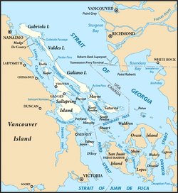
Valdes Island

Last updated

Valdes Island
Island
Kayak-Valdes-BC.jpg
A kayak and a sunset on Valdes Island.
Gulf Islands map 2.png
The Southern Gulf Islands, including Valdes.
CountryCanada
Province British Columbia
Land district Cedar Land District
Region Southern Gulf Islands
Government
   MP Lisa Marie Barron (NDP)
   MLA Doug Routley (BC NDP)
Area
  Total23 km2 (9 sq mi)
Population
 (2016)
  Total10
 Population for Dissemination Block 59190308003
Time zone UTC−8 (PST)
  Summer (DST) UTC−7 (PDT)
Area code(s) 250, 778

Valdes Island [1] is one of the Gulf Islands located in the Strait of Georgia, British Columbia, Canada. It is across Porlier Pass from Galiano Island, which lies to the southeast. It has an area of 23 square kilometres (9 square miles), and is 1.6 kilometres (1.0 mile) wide by 16 kilometres (9.9 miles) in length. The island is popular with kayakers, boaters and has historically been the site of several human settlements.

Contents

Naming and early exploration

It is named for Spanish explorer Cayetano Valdés y Flores, who first came to the region in 1791 [2] as a lieutenant serving under Captain Alessandro Malaspina on the Descubierta. Valdes returned later in 1792 as captain of the Mexicana to explore the area with Dionisio Alcalá Galiano who captained the Sutil . [3] The island was given its name in 1859 by George Henry Richards, captain of HMS Plumper. [4]

Settlement

Currently there are few permanent residents on Valdes Island. One third of the island is set aside as three Indian reserves of the Lyackson First Nation. [5] [6] [7] [8] At Shingle Point, which is the location of one of those reserves, the island shows evidence of human habitation from at least 5,000 years ago in the form of approximately 60 archeological sites. [3]

Brother XII

Valdes Island was one of the locations of the colonies of the Aquarian Foundation, the BC-based cult run by Brother XII in the late 1920s and early 1930s The organization had several buildings on the island, of which little trace remains today. There were also rumours that money was buried on the island, but these have never been proven.

Some of the geology that is commonplace on Valdes island. Valdes Island Sandstone Formations.jpg
Some of the geology that is commonplace on Valdes island.

Cave

There is a cave in the middle of the island. According to legend, it runs under the sea to emerge on Thetis Island, but recent explorers have found that rockfalls have made remote parts too narrow for human passage.

Cave on Valdes Island Cave on Valdes Island.jpg
Cave on Valdes Island

Recreational activities

Wakes Cove Provincial Park and the Blackberry Point Campsite are located on the island. These two campsites, as well as an abundance of wildlife and unusual sandstone geology make this island a popular destination for recreational kayaking and camping. The Blackberry Point Campsite was the first campsite established as part of the BC Marine Trails Network by Peter McGee in the early 1990s. [9] The site at Wakes Cove is still undeveloped, lacking any facilities for campers, however there is an abandoned well along an overgrown road in the area. The Blackberry Point site has defined cooking and tenting spaces, trails from the beach as well as a composting toilet.

Killer whales are abundant around the island.

Related Research Articles

<span class="mw-page-title-main">Gulf Islands National Park Reserve</span> National park reserve in British Columbia, Canada

Gulf Islands National Park Reserve is a national park located on and around the Gulf Islands in British Columbia, Canada. In the National Parks System Plan, this park provides representation of the Strait of Georgia Lowlands natural region, the only place in Canada with a Mediterranean climate of dry, sunny summers and mild, wet winters, the result of a rain shadow effect from surrounding mountains between the region and the ocean. It has similar dominant vegetation as the Pacific Northwest, such as coastal Douglas-fir, western red cedar, shore pine, Pacific dogwood, bigleaf maple, and red alder, but also contains the northern extent of some of the more drought tolerant trees such as Garry oak and Arbutus. The park was created in 2003 as the fortieth national park. It covers 36 square kilometres (14 sq mi) of area on 16 islands and more than 30 islets, reefs and surrounding waters, making it the sixth smallest national park in Canada.

<span class="mw-page-title-main">Pender Island</span> Island in British Columbia, Canada

Pender Island is one of the Southern Gulf Islands located in the Gulf of Georgia, British Columbia, Canada. Pender Island is approximately 34 km2 (13 sq mi) in area and is home to about 2,250 permanent residents, as well as a large seasonal population. Like most of the rest of the Southern Gulf Islands, Pender Island enjoys a sub-Mediterranean climate and features open farmland, rolling forested hills, several lakes and small mountains, as well as many coves and beaches.

<span class="mw-page-title-main">Galiano Island</span> Island in British Columbia, Canada

Galiano Island is one of the Southern Gulf Islands located between Vancouver Island and the Lower Mainland of British Columbia, Canada. Located on the west side of the Strait of Georgia, the island is bordered by Mayne Island to the southeast, Salt Spring Island to the west and Valdes Island to the northwest. Galiano is part of the Capital Regional District Electoral Area G, and has a permanent population of 1,396 inhabitants as of 2021.

<span class="mw-page-title-main">Mayne Island</span> Island in British Columbia, Canada

Mayne Island is a 21-square-kilometre (8.1 sq mi) island in the southern Gulf Islands chain of British Columbia. It is midway between the Lower Mainland of BC and Vancouver Island, and has a population of 995. Mount Parke in the south-central heart of the island is its highest peak at 255 metres.

<span class="mw-page-title-main">Ganges, British Columbia</span>

Ganges, British Columbia is an unincorporated community on Salt Spring Island in the province of British Columbia, Canada.

<span class="mw-page-title-main">Collinson Point Provincial Park</span> Provincial park in British Columbia, Canada

Collinson Point Provincial Park is a provincial park on Galiano Island, British Columbia, Canada. It is located between Mount Galiano and the western approaches to Active Pass. The area is 24 hectares, with c. 500 metres of waterfront.

<span class="mw-page-title-main">Dionisio Point Provincial Park</span> Provincial park on Galiano Island in British Columbia, Canada

Dionisio Point Provincial Park is a provincial park campground in the southern Gulf Islands of British Columbia, Canada. It is located at the northwestern tip of Galiano Island, across Porlier Pass from Valdes Island.

<span class="mw-page-title-main">Saturna Island</span> Island of the Gulf Islands in British Columbia, Canada

Saturna Island is a mountainous island, about 31 square kilometres (12 sq mi) in size, in the Southern Gulf Islands chain of British Columbia, Canada. It is situated approximately midway between the Lower Mainland of B.C. and Vancouver Island, and is the most easterly of the Gulf Islands. It is surrounded on three sides by the Canada–United States border. To the north is Point Roberts, Washington, and to the east and south are the San Juan Islands. There is a First Nations reserve on the island for the Tsayout and Tseycum Nations. The island has a permanent population of around 350, however, this number increases during the summer season.

<span class="mw-page-title-main">Discovery Island (British Columbia)</span>

Discovery Island is located off the eastern side of Vancouver Island and is viewable from Ten Mile Point, near Cadboro Bay, and Oak Bay. Discovery Island Marine Provincial Park occupies the southern portion of Discovery Island, 3 miles (4.8 km) east of Oak Bay. The northern portion of the island is part of Discovery Island Indian Reserve 3, under the control of the Songhees First Nation.

<span class="mw-page-title-main">Hernando Island</span>

Hernando Island is one of the Discovery Islands near Powell River, British Columbia, Canada. Along with the nearby Cortes Island, it was presumably named in 1792 by Valdés and Galiano after Hernán Cortés, the Spanish conqueror of Mexico.

<span class="mw-page-title-main">Cortes Island</span> Island of the Discovery Islands in British Columbia, Canada

Cortes Island is an island in the Discovery Islands archipelago on the coast of British Columbia, Canada. The island is 25 km (16 mi) long, 13 km (8 mi) wide, and 130 km2 (50 sq mi) in area. It has a population of 1,035 permanent residents. Cortes Island lies within Electoral Area B of the Strathcona Regional District, which provides water and sewerage systems, fire protection, land use planning, parks, recreation, and emergency response.

Aristazabal Island is an island situated south west of Princess Royal Island in British Columbia, Canada. It has an area of 420 square kilometres (160 sq mi). It was named on August 30, 1792 by Lieutenant Commander Jacinto Caamaño of the Spanish corvette Aranzazu for Spanish captain Gabriel de Aristazábal, one of the most noted Spanish commanders of the time. It was misspelled "Aristizable" on a chart owned by English explorer George Vancouver.

<span class="mw-page-title-main">Parker Island</span>

Parker Island is a roughly 400-acre (160 ha) island in the Southern Gulf Islands of British Columbia, Canada. It forms the western side of Montague Harbour, sheltering it from the strong wind gusts of Trincomali Channel. The island may be reached by floatplane, private boat, helicopter or water taxi; there is no public ferry service.

The Malaspina Peninsula is a peninsula in the northern Gulf of Georgia-Sunshine Coast region of British Columbia, Canada. It extends northwest from the town of Powell River, which lies near its isthmus, past the settlement of Lund, to Desolation Sound. This sound spans the opening of Toba Inlet, a fjord lying between Lund and the Discovery Islands to the west and northwest.

Malaspina Strait is a strait in the northern Gulf of Georgia-Sunshine Coast region of British Columbia, Canada. It separates Texada Island from the upper Sunshine Coast-Malaspina Peninsula area on the adjacent mainland.

The Defence Islands are two small islands in Howe Sound, British Columbia, Canada, northeast of Anvil Island and in the northern reaches of that sound near Porteau Cove. The easterly and smaller of the two comprises Defence Island Indian Reserve No. 28 ; the westerly comprises the Kwum Kwum Indian Reserve, both under the administration of the Squamish Nation.

<span class="mw-page-title-main">Portland Island (British Columbia)</span>

Portland Island is an island of the Southern Gulf Islands of the South Coast of British Columbia, Canada. It is located in the Salish Sea west of Moresby Island and off the south tip of Saltspring Island, adjacent to the main BC Ferries route just offshore from the terminal at Swartz Bay at the tip of the Saanich Peninsula. It was named after HMS Portland, the flagship of Rear-Admiral Fairfax Moresby, Commander in Chief of the Pacific Station 1850–1853.

<span class="mw-page-title-main">Trincomali Channel</span> Channel in British Columbia, Canada

Trincomali Channel is a channel between Galiano Island and Saltspring Island in the Gulf Islands of British Columbia, Canada.

The Lyackson First Nation is a First Nations band government located at Chemainus, British Columbia, Canada, on Vancouver Island.

Cape Sutil is the headland at the northernmost point of Vancouver Island, in the Canadian Province of British Columbia.

References

  1. "Valdes Island". BC Geographical Names .
  2. Walbran, Captain John T. (1971). British Columbia Place Names, Their Origin and History (Facsimile reprint of 1909 ed.). Vancouver/Toronto: Douglas & McIntyre. ISBN   0-88894-143-9. Archived from the original on 2016-03-03. Retrieved 2014-07-06.
  3. 1 2 "Valdes Island, British Columbia, Canada". www.vancouverisland.com. Archived from the original on 2006-03-19.
  4. Walbran, John T. (1909). British Columbia Coast Names, 1592–1906 : to which are added a few names in adjacent United States territory, their origin and history. Ottawa Government Printing Bureau. p. 501. OCLC   317633225. Archived from the original on 2012-03-07. Retrieved 2012-10-24.
  5. "Lyacksun Indian Reserve 3". BC Geographical Names .
  6. "Porlier Pass Indian Reserve 5". BC Geographical Names .
  7. "Shingle Point Indian Reserve 4". BC Geographical Names .
  8. "Indian and Northern Affairs Canada – Reserves/Settlements/Villages Detail". Crown–Indigenous Relations and Northern Affairs Canada . Government of Canada. 14 November 2008. Retrieved 2010-03-26.
  9. "BC Marine Trails: Paddling Vancouver Island, Gulf Islands, Broken Group, Johnstone Strait, Haida Gwaii, North and South Coast - BC Marine Trails Network: Connecting the BC coast".

49°05′N123°40′W / 49.083°N 123.667°W / 49.083; -123.667