
Saysutshun Provincial Park, formally known as Newcastle Island Marine Provincial Park, is a provincial park located on a small island off the coast of Nanaimo, British Columbia, Canada.

Gulf Islands National Park Reserve is a national park located on and around the Gulf Islands in British Columbia, Canada. In the National Parks System Plan, this park provides representation of the Strait of Georgia Lowlands natural region, the only place in Canada with a Mediterranean climate of dry, sunny summers and mild, wet winters, the result of a rain shadow effect from surrounding mountains between the region and the ocean. It has similar dominant vegetation as the Pacific Northwest, such as coastal Douglas-fir, western red cedar, shore pine, Pacific dogwood, bigleaf maple, and red alder, but also contains the northern extent of some of the more drought tolerant trees such as Garry oak and Arbutus. The park was created in 2003 as the fortieth national park. It covers 36 square kilometres (14 sq mi) of area on 16 islands and more than 30 islets, reefs and surrounding waters, making it the sixth smallest national park in Canada.

Point Lobos and the Point Lobos State Natural Reserve is a state park in California. Adjoining Point Lobos is "one of the richest marine habitats in California." The ocean habitat is protected by two marine protected areas, the Point Lobos State Marine Reserve and Point Lobos State Marine Conservation Area. The sea near Point Lobos is considered one of the best locations for scuba diving on the Monterey Peninsula and along the California coast.

Porteau Cove Provincial Park is a provincial park located along the eastern shore of Howe Sound in British Columbia, Canada.

SS Princess Sophia was a steel-built passenger liner in the coastal service fleet of the Canadian Pacific Railway (CPR). Along with SS Princess Adelaide, SS Princess Alice, and SS Princess Mary, Princess Sophia was one of four similar ships built for CPR during 1910-1911.
Howe Sound is a roughly triangular sound, that joins a network of fjords situated immediately northwest of Vancouver, British Columbia, Canada. It was designated as a UNESCO Biosphere Reserve in 2021.

Vargas Island Provincial Park is a provincial park in British Columbia, Canada, comprising the west side of the island of the same name, which is located west of Meares Island and northwest of the resort community of Tofino in the Clayoquot Sound region of the West Coast of Vancouver Island, British Columbia, Canada. The park was created as part of the Clayoquot Land-Use Decision on July 13, 1995 and contains 5,805 hectares, 1,543 hectares of it being upland and 4,262 hectares being foreshore. Also located on Vargas Island, on its north side, is Epper Passage Provincial Park.
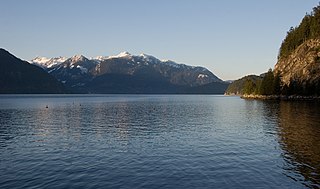
Apodaca Provincial Park is a provincial park located on the central eastern shoreline of Bowen Island, British Columbia, Canada.

Gibson Marine Provincial Park is a provincial park in British Columbia, Canada, located on the southeast end of Flores Island in the central Clayoquot Sound region of Vancouver Island. The park was created on 13 November 1967. It contains approximately 143 hectares and is adjacent to Flores Island Provincial Park.
ȽÁU,WELṈEW̱/John Dean Provincial Park, formerly John Dean Provincial Park, is a small, densely vegetated provincial park on the Saanich Peninsula of southern Vancouver Island, British Columbia, Canada. The park is located on and around ȽÁU,WELṈEW̱, a small mountain in the traditional territory of Wsanec First Nations, itself situated 20 km north of Victoria, the provincial capital city.

Wakes Cove Provincial Park is a provincial park in the northeast corner of Valdes Island, located in the Gulf Islands in British Columbia, Canada. The park is only accessible by boat, and can be found on Marine Chart #3475 for further navigation details.

Maquinna Marine Provincial Park and Protected Area is a provincial park in British Columbia, Canada, located northwest of Tofino in the Clayoquot Sound region of the West Coast of Vancouver Island, protecting Ramsay Hot Springs, which is the name-source of the cove, settlement and former post office of Hot Springs Cove.
Memory Island Provincial Park is a provincial park located on Vancouver Island in British Columbia, Canada. It was established by BC Parks on 23 August 1945 to protect a small island located at the southern end of Shawnigan Lake.

Smuggler Cove Marine Provincial Park is a provincial park in British Columbia, Canada located approximately 16 kilometres (9.9 mi) west of Sechelt, a city on the Sunshine Coast.

De Courcy Island is one of the Gulf Islands of the coast of southwestern British Columbia, Canada, located between the Pylades and Stuart Channels approximately 16 km (9.9 mi) southeast of Nanaimo and approximately 38 km (24 mi) west of Vancouver.

Cortes Island is an island in the Discovery Islands archipelago on the coast of British Columbia, Canada. The island is 25 km (16 mi) long, 13 km (8 mi) wide, and 130 km2 (50 sq mi) in area. It has a population of 1,035 permanent residents. Cortes Island lies within Electoral Area B of the Strathcona Regional District, which provides water and sewage systems, fire protection, land use planning, parks, recreation, and emergency response.

Keats Island is an inhabited island located in Howe Sound near Vancouver, British Columbia. Most people who spend time on the island are visitors to one of the camps or the Marine Park, or owners of seasonal cottages.

Princess Louisa Inlet is a fjord on British Columbia’s Sunshine Coast and within the swiya of the shíshálh Nation.
Robson Bight is a small Vancouver Island bay at the west end of Johnstone Strait across from West Cracroft Island in British Columbia, Canada that includes a protected killer whale habitat famous for its whale-rubbing beaches. The bight is adjacent to Lower Tsitika River Provincial Park. The nearest access point is Telegraph Cove on the east coast of Northern Vancouver Island.

Portland Island is an island of the Southern Gulf Islands of the South Coast of British Columbia, Canada. It is located in the Salish Sea west of Moresby Island and off the south tip of Saltspring Island, adjacent to the main BC Ferries route just offshore from the terminal at Swartz Bay at the tip of the Saanich Peninsula. It was named after HMS Portland, the flagship of Rear-Admiral Fairfax Moresby, Commander in Chief of the Pacific Station 1850–1853.


