
The Peace River is a 1,923-kilometre-long (1,195 mi) river in Canada that originates in the Rocky Mountains of northern British Columbia and flows to the northeast through northern Alberta. The Peace River joins the Athabasca River in the Peace-Athabasca Delta to form the Slave River, a tributary of the Mackenzie River. The Finlay River, the main headwater of the Peace River, is regarded as the ultimate source of the Mackenzie River. The combined Finlay–Peace–Slave–Mackenzie river system is the 13th longest river system in the world.

The Black Tusk, known as Q̓elqámtensa ti Skenknápa in the St'at'imcets (Lillooet) language and as T'ákt'akmúten tl'a Ín7inyáx̱a7en in the Sḵwx̱wú7mesh (Squamish) language, is a stratovolcano and a pinnacle of volcanic rock in Garibaldi Provincial Park of British Columbia, Canada. At 2,319 m (7,608 ft) above sea level, the upper spire is visible from a great distance in all directions. It is particularly noticeable from the Sea-to-Sky Highway just south of Whistler, British Columbia. Distinctive and immediately identifiable, The Black Tusk is among the best known mountains in the Garibaldi Ranges of the Coast Mountains. The volcano is part of the Garibaldi Volcanic Belt which is a segment of the Canadian Cascade Arc, but it is not within the geographic boundary of the Cascade Range.
Babine Lake Marine Park is on Babine Lake, which borders the Skeena and Omineca regions of central British Columbia. This provincial park comprises six separate sites around the lake. Vehicle access to the lake, via BC Highway 16 and Nilkitkwa forestry service road, is by road about 105 kilometres (65 mi) northeast of Smithers; via BC Highway 16 and Central Babine Lake Highway, is about 132 kilometres (82 mi) east of Smithers; or via Babine Lake Road, is about 20 kilometres (12 mi) northeast of Burns Lake.
Chase Provincial Park is a provincial park in British Columbia, Canada, located around Carina and Tomias Lakes, 70 kilometres (43 mi) north of Germansen Landing in the Omineca Mountains and just west of the Finlay Arm of Williston Lake. Approximately 32,226 hectares (124.43 sq mi), it was established in 2001.
Gabriola Sands Provincial Park is a provincial park in British Columbia, Canada. The park is located on an isthmus between Taylor Bay and Pilot Bay, and includes the beaches and waters of each. It has a day-use area with a fielded area that can be used for picnicking.

Hesquiat Peninsula Provincial Park is a provincial park at the western extremity of the Clayoquot Sound region of the West Coast of Vancouver Island, British Columbia, Canada. The park was established by order-in-council on July 12, 1995 as part of the Clayoquot Land-Use Decision.

Kokanee Creek Provincial Park is a provincial park on the west shore of Kootenay Lake in the West Kootenay region of southeastern British Columbia. Highway 3A bisects the park 19 kilometres (12 mi) east of Nelson.
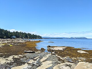
Mansons Landing Provincial Park is a provincial park in British Columbia, Canada, located at Mansons Landing on Cortes Island. It was established in 1974 and covers 100 hectares, including 47 hectares of upland and 53 hectares of foreshore.
Mount Geoffrey Escarpment Provincial Park is a Class-A provincial park in British Columbia, Canada, located on the southwest coast of Hornby Island. It covers an area of 187 hectares, stretching from the Shingle Spit ferry landing in the west to Ford Cove in the east.
Peace River Corridor Provincial Park is a 2014 ha provincial park in British Columbia, Canada. It is located on the banks of the Peace River, at the confluence with Kiskatinaw River, downstream from Taylor. It is in the Boreal White and Black Spruce biogeoclimatic zone within the Peace Lowlands ecosection. It is used by ungulates as a winter range and by migratory waterfowl as a staging area.

Plumper Cove Marine Provincial Park is a provincial park in British Columbia, Canada. The park is located on the northwest shore of Keats Island in Howe Sound, northwest of Vancouver, British Columbia.

Sir Alexander Mackenzie Provincial Park is a provincial park in British Columbia, Canada. Located at the mouth of Elcho Harbour on Dean Channel, it enshrines the farthest point west reached by Alexander Mackenzie in 1793 and the rock he marked to commemorate his journey. The park is also the location of a historical First Nations village, with petroglyphs that can be found along the beach.
Steelhead Provincial Park is a provincial park in the Thompson Country region of south central British Columbia, Canada. The facility is at the west end of Kamloops Lake near the town of Savona. On BC Highway 1, the locality is by road about 38 kilometres (24 mi) east of Cache Creek and 45 kilometres (28 mi) west of Kamloops.
Taylor Arm Provincial Park is a provincial park in British Columbia, Canada, located on the north side of Sproat Lake 23 km northwest of Port Alberni on Vancouver Island. Situated along Highway 4, the 71-hectare park has few services but provides group camping sites, undeveloped beaches, and day-use areas. The group camping site has pit toilets and a hand pump water supply, and is connected to the lake shore via a trail that passes under the highway.
Topley Landing Provincial Park is a provincial park near Topley Landing in British Columbia, Canada.
Highway 4 is a major provincial highway in the Canadian province of Saskatchewan. It runs from U.S. Route 191 at the United States border near Monchy to Highway 224 / Highway 904 in Meadow Lake Provincial Park. Highway 4 is about 652 kilometres (405 mi) long.

Cabots Landing Provincial Park is a small picnic and beach park on the shore of Aspy Bay in the community of Sugarloaf, 10 kilometres (6.2 mi) north of the Cabot Trail on Cape Breton Island, Nova Scotia, Canada.

Danielson Provincial Park is located at the northern end of Lake Diefenbaker in the southern part of the Canadian province of Saskatchewan. The park surrounds the Gardiner Dam, which was built in 1967 and is among the largest embankment dams in Canada and the world. The South Saskatchewan River flows north beyond the park, towards Outlook and Saskatoon. Saskatchewan Highways 44, 45, and 219 provide access to the park. SaskPower's Coteau Creek Hydroelectric Station is located near the park.

Saskatchewan Landing Provincial Park is a provincial park in the Canadian province of Saskatchewan. It is in the valley of the South Saskatchewan River at the western end of Lake Diefenbaker in the RM of Saskatchewan Landing No. 167, about 50 kilometres (31 mi) north of Swift Current. The park is 5,735 hectares in size.
Omineca Provincial Park and Protected Area is a provincial park and protected area located in the north-central interior of British Columbia, Canada. It was established on 11 April 2001 by BC Parks to protect provincially significant riparian and wetland habitats along the Omineca River.

