
Adams Lake Provincial Park is a provincial park in British Columbia, Canada. It encompasses three distinct parks: Adams Lake Provincial Park, Adams Lake Marine Provincial Park, and Adams Lake Marine Provincial Park.

Alice Lake Provincial Park is a provincial park in British Columbia, Canada.
Babine Lake Marine Park is on Babine Lake, which borders the Skeena and Omineca regions of central British Columbia. This provincial park comprises six separate sites around the lake. Vehicle access to the lake, via BC Highway 16 and Nilkitkwa forestry service road, is by road about 105 kilometres (65 mi) northeast of Smithers; via BC Highway 16 and Central Babine Lake Highway, is about 132 kilometres (82 mi) east of Smithers; or via Babine Lake Road, is about 20 kilometres (12 mi) northeast of Burns Lake.

Quatsino Provincial Park is a provincial park in British Columbia, Canada, located on Quatsino Sound on northern Vancouver Island. The park was established July 12, 1995 and is 654 hectares in size. The park is 50 kilometres (31 mi) west of Port Hardy, British Columbia and is accessible by rough logging roads or by boat. Quatsino is on a popular kayaking route.

Codville Lagoon Marine Provincial Park is a provincial park in British Columbia, Canada, located on the southwest end of King Island. The park was created in 1965 because it is a significant site to the Heiltsuk People. This park, which is approximately 755 ha. in area, has an unmaintained trail to Sagar Lake which has a red sand beach. Created in 1992, it was expanded in 1995 by the incorporation of the former Sugar Lake Provincial Park.
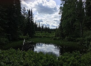
Eskers Provincial Park is a provincial park in British Columbia, Canada. The park comprises roughly 4,044 hectares and was created in 1987. Located west of Nukko Lake, which lies northwest of the city of Prince George, it protects an area of the 40-kilometre (25 mi) Stuart River Eskers Complex. Eskers are winding ridges of gravel formed by the glaciers which once covered the British Columbia Interior.

Kakwa Provincial Park and Protected Area is a 170,890 ha provincial park in northeastern British Columbia, Canada. The park preserves the southernmost portion of the Hart Ranges and the northernmost portion of the Continental Ranges. The park also preserves significant marine fossil deposits located in the region.

Klewnuggit Inlet Marine Provincial Park is a provincial park in British Columbia, Canada, located on the east side of Grenville Channel, 100 kilometres (62 mi) southeast of Prince Rupert, in the Range 4 Coast Land District.
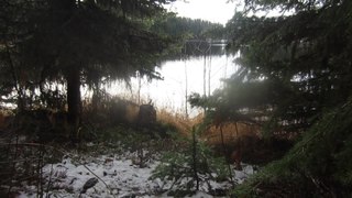
Little Andrews Bay Marine Provincial Park is a provincial park in British Columbia, Canada, located on Ootsa Lake in the Nechako Country in that province's Central Interior. It is 102 hectares in size.

Mara Provincial Park is a day-use provincial park in British Columbia, Canada, located on Mara Lake south of Sicamous. The park is open with services from May 1 to September 27. The gate is locked open during the off season.
Paarens Beach Provincial Park is a provincial park in central British Columbia, Canada. It is located on the south-west shore of Stuart Lake, to the west of Fort St. James.
Sowchea Bay Provincial Park is a provincial park in central British Columbia, Canada. It is on Stuart Lake, west of Prince George. The park is 13 hectares in area. It is a busy destination for boaters and anglers, with a single-lane concrete boat launch available with limited parking.
Stuart River Provincial Park is a provincial park in British Columbia, Canada. It is located in two sections north and northwest of Vanderhoof along the Stuart River southeast of Stuart Lake and the city of Fort St. James. The upper section is located at 54°13′20″N124°00′00″W and comprises c.7391 ha. while the lower, eastern section is centred at 54°03′00″N123°37′00″W and comprises c.3390 ha. and is within the Greater Prince George area. The upper site, which is located around the confluence of the Stuart and Nechako Rivers, includes the site of Chinlac, a Dakelh village whose inhabitants were massacred and enslaved by the Tsilhqot'in of Anahim Lake c. 1745.
Takla Lake Marine Provincial Park is a provincial park in British Columbia, Canada. Located northeast of the town of Smithers and roughly parallel to Babine Lake to its west/southwest, it comprises three sites on Takla Lake in the northwestern part of the Omineca Country of the province's North-Central Interior. The three sites are the Sandy Point Site, containing about 160 ha, Takla Lake West containing about 41 ha, and White Bluff, containing about 349 ha.
Trembleur Lake Provincial Park is a provincial park in British Columbia, Canada.
The Marine Drive is a designated scenic route along Nova Scotia's Eastern Shore. It closely follows the coast of the Atlantic Ocean and the Strait of Canso from the Canso Causeway to the junction of Route 322 and Highway 111 in Dartmouth.
The Okanagan Highland is an elevated hilly plateau area in British Columbia, Canada, and the U.S. state of Washington. Rounded mountains with elevations up to 8,000 ft (2,400 m) above sea level and deep, narrow valleys are characteristic of the region.

Takla Lake is the fifth largest natural lake in British Columbia, Canada. It is a deep fjord-like lake with the Swannell Ranges to the east, the Driftwood River flowing into it from the north, and the Middle River draining it. It is the terminus of the early Stuart-Takla sockeye salmon run, and noted for its large rainbow trout, lake trout and Dolly Varden. The peninsula is the home of Mount Blanchet Provincial Park. Also on the peninsula is a herd of collared woodland caribou, and the winter range of grizzly bears. Two special features are Takla Lake Marine Park, and an Ecological Reserve on the peninsula, a stand of very northerly Douglas Fir. Takla Lake is also the origin of both of Canada's national airlines, both Russ Baker and Grant McConachie running bush plane routes out of Takla Lake. It is a popular canoe route from the top end down to Fort St. James.
Greenwater Lake Provincial Park is a provincial park in the Canadian province of Saskatchewan. It is located on the eastern side of the province in the Porcupine Hills on Highway 38. The closest town, Porcupine Plain, is about 28 kilometres (17 mi) to the north-east of the park visitor centre. Founded on 19 February 1932, Greenwater is one of the oldest provincial parks in Saskatchewan. The original six parks were established in 1931 and Greenwater Provincial Park was added one year later. In 1964, the park was expanded to its current size.
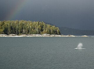
Clayoquot Sound Biosphere Reserve is a UNESCO Biosphere Reserve situated in Clayoquot Sound on the west coast of Vancouver Island in British Columbia, Canada. A diverse range of ecosystems exist within the biosphere reserve boundaries, including temperate coastal rainforest, ocean and rocky coastal shores.

