The Canadian Wildlife Service or CWS, is a Branch of the Department of Environment and Climate Change Canada, a department of the Government of Canada. November 1, 2012 marked the 65th anniversary of the founding of Service.

Protected areas of Canada consist of approximately 12.1 percent of the nation's landmass and freshwater are considered conservation areas, including 11.4 percent designated as protected areas. Approximately 13.8 percent of Canada's territorial waters are conserved, including 8.9 percent designated as protected areas. Terrestrial areas conserved have increased by 65 percent in the 21st century, while marine areas conserved have increased by more than 3,800 percent.
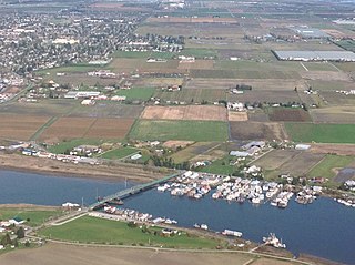
Westham Island is an island located near Ladner, British Columbia, Canada within the City of Delta, which in turn is part of Greater Vancouver, Canada. The George C. Reifel Migratory Bird Sanctuary for migratory birds is located at the northern end of the island, home to over 300 bird species. Every year in October, almost 85,000 Lesser Snow Geese arrive as they travel from Wrangel Island to the Atlantic. The Alaksen National Wildlife Area is also located on the island.

The Pacific Flyway is a major north-south flyway for migratory birds in the Americas, extending from Alaska to Patagonia. Every year, migratory birds travel some or all of this distance both in spring and in fall, following food sources, heading to breeding grounds, or travelling to overwintering sites.
The Alaksen National Wildlife Area is located on Westham Island in the city of Delta, British Columbia. It is an important stopover point for many species of birds migrating along the Pacific Flyway.

Chaplin Lake is a salt lake in the south-west corner of the Canadian province of Saskatchewan. The lake is in the Prairie Pothole Region of North America, which extends throughout three Canadian provinces and five U.S. states, and within Palliser's Triangle and the Great Plains ecoregion of Canada. Along the northern shore is the village of Chaplin, Chaplin Nature Centre, and a sodium sulphate mine owned and operated by Saskatchewan Mining and Minerals. The lake is divided into four sections by dykes built by the mining company. The Trans-Canada Highway runs along the northern shore and Highway 58 runs through the middle of the lake in a south to north direction.

Oak Hammock Marsh is a marsh and a wildlife management area located 34 kilometres (21 mi) north of Winnipeg, Manitoba, Canada. The WMA is considered to be a Class IV protected area under the IUCN protected area management categories. The marsh is recognized as an Important Bird Area (IBA) for its globally significant numbers of waterfowl and shorebirds. It is a designated Ramsar site due to its international importance as a breeding and staging area for waterfowl and other migratory birds. It is 3,578.47 hectares in size.

The Migratory Birds Convention Act is a Canadian law established in 1917 and significantly updated in June 1994 which contains regulations to protect migratory birds, their eggs, and their nests from destruction by wood harvesting, hunting, trafficking and commercialization. A permit is required to engage in any of these activities.

The Quill Lakes is a wetland complex in Saskatchewan, Canada that encompasses the endorheic basin of three distinct lake wetlands: Big Quill Lake, Middle Quill Lake, and Little Quill Lake. On May 27, 1987, it was designated a wetland of international importance via the Ramsar Convention. It was the first Canadian site in the North American Waterfowl Management Plan, is a site in the International Biological Programme and Saskatchewan Heritage Marsh Program, and was designated a Western Hemisphere Shorebird Reserve Network site of International significance in May, 1994. The site is an important staging and breeding area for spring and fall migration of shorebirds. The site qualifies as an Important Bird Area (IBA) of Canada for its globally and nationally significant migratory and breeding populations of more than a dozen species of birds. The IBA is designated as Quill Lakes .

Mary's Point is a 12 square kilometres (4.6 sq mi) wetland in Albert County, New Brunswick, Canada. It is at the head of the Bay of Fundy, just outside the small community of Harvey and approximately 40 km (25 mi) south of Moncton. Designated a Ramsar wetland of international importance on May 24, 1982, it is also part of the Fundy biosphere reserve established in 2007, which also contains the Shepody Bay wetland. It was also the first Canadian site in the Western Hemisphere Shorebird Reserve, as part of the Bay of Fundy Hemisphere Shorebird Reserve. It is within the Shepody Bay National Wildlife Area, which is administered by the Canadian Wildlife Service.

Kirkland Island, also known as Rose-Kirkland Island, is located within the municipality of Richmond, British Columbia and is part of a small alluvial archipelago known as the South Arm Marshes located within the Ladner Reach of the South Arm of the Fraser River in British Columbia, Canada. It is the northernmost island of the group and lies between Richmond on Lulu Island in the north and Delta and Ladner town centre in the south.
The San Luis National Wildlife Refuge Complex is located in the northern San Joaquin Valley, within Merced County and Stanislaus County of California. The complex, with four federal National Wildlife Refuges, is managed by the U.S Fish & Wildlife Service.

Ottawa National Wildlife Refuge is a National Wildlife Refuge of the United States, which is located in the state of Ohio. This refuge was established in 1961, under the Migratory Bird Conservation Act, the purpose of the refuge being created was “… for use as an inviolate sanctuary, or for any other management purpose, for migratory birds.” 16 U.S.C. 715d. This refuge provides ideal habitat for a wide range for migratory birds and waterfowl, along with the native wildlife, and any endangered and threatened species. The property of the refuge was purchased from hunt clubs and farmlands with the Federal Duck Stamps.
Long Lake National Wildlife Refuge, located in south-central North Dakota, was established in 1932 as a migratory bird refuge by President Herbert Hoover. The 22,300-acre (90 km2) refuge consists of a 15,000-acre (61 km2) saline basin that is 18 miles (29 km) long and is appropriately named "Long Lake." Long Lake is relatively shallow; it is normally 3–4 feet (0.91–1.22 m) deep. During extended wet periods, Long Lake reaches depths up to 7 feet (2.1 m).

The Kendall Island Migratory Bird Sanctuary (KIBS) is a migratory bird sanctuary in the Northwest Territories, Canada. It is located on Kendall Island and its surrounding area in Mackenzie Bay at the northern tip of the Mackenzie River Delta. A seasonal sanctuary for more than 60,000 shorebirds, it is one of five bird sanctuaries within the Inuvialuit Settlement Region. The area that is now known as the KIBS is a traditional Inuvialuit whaling site.

The Adelaide International Bird Sanctuary National Park—Winaityinaityi Pangkara is a protected area in South Australia established by the South Australian government on the northeast coast of Gulf St Vincent, between Parham in the north and the southern end of Barker Inlet in the south, for the purpose of rehabilitating land used as salt pans, protecting habitat for international migratory shorebirds, managing water quality in adjoining parts of Gulf St Vincent, creation of "green" space, development of niche tourism and creation of opportunities for Indigenous people.
Last Mountain Lake Bird Sanctuary is a National Historic Site of Canada, located in the rural municipality of Last Mountain Valley No. 250 in Saskatchewan. The migratory bird sanctuary was the first established in North America. The 47.36 km2 (18.29 sq mi) area is within the Last Mountain Lake National Wildlife Area, an International Biological Program site, and includes adjacent uplands.

The Coppename Monding Nature Reserve is a protected area and nature reserve in Suriname. The reserve is located near the mouth of the Coppename River. The reserve measures 12,000 hectares, and has been a protected area since 1961.
Last Mountain Lake National Wildlife Area is a National Wildlife Area (NWA) in the Canadian province of Saskatchewan. The protected area is in the Prairie Pothole Region of North America, which extends throughout three Canadian provinces and five U.S. states. It is also within Palliser's Triangle and the Great Plains ecoregion. The site is an Important Bird Area (IBA) of Canada, designated as Last Mountain Lake NWA .


