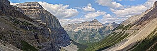
Kootenay National Park is a national park of Canada in southeastern British Columbia. The park consists of 1,406 km2 (543 sq mi) of the Canadian Rockies, including parts of the Kootenay and Park mountain ranges, the Kootenay River and the entirety of the Vermilion River. While the Vermilion River is completely contained within the park, the Kootenay River has its headwaters just outside the park boundary, flowing through the park into the Rocky Mountain Trench and eventually joining the Columbia River. The park ranges in elevation from 918 m (3,012 ft) at the southwestern park entrance to 3,424 m (11,234 ft) at Deltaform Mountain.

The Kootenay River or Kootenai River is a major river of the Northwest Plateau in southeastern British Columbia, Canada, and northern Montana and Idaho in the United States. It is one of the uppermost major tributaries of the Columbia River, the largest North American river that empties into the Pacific Ocean. The Kootenay River runs 781 kilometres (485 mi) from its headwaters in the Kootenay Ranges of the Canadian Rockies, flowing from British Columbia's East Kootenay region into northwestern Montana, then west into the northernmost Idaho Panhandle and returning to British Columbia in the West Kootenay region, where it joins the Columbia at Castlegar.

Glacier National Park is part of a system of 43 parks and park reserves across Canada, and one of seven national parks in British Columbia. Established in 1886, the park encompasses 1,349 km2 (521 sq mi), and includes a portion of the Selkirk Mountains which are part of the larger grouping of mountains, the Columbia Mountains. It also contains the Rogers Pass National Historic Site.

Garibaldi Provincial Park, also called Garibaldi Park, is a wilderness park located on the coastal mainland of British Columbia, Canada, 70 kilometres (43.5 mi) north of Vancouver. It was established in 1920 and named a Class A Provincial Park of British Columbia in 1927. The park is a popular destination for outdoor recreation, with over 30,000 overnight campers and over 106,000 day users in the 2017/2018 season.

The Purcell Mountains are a mountain range in southeastern British Columbia, Canada. They are a subrange of the Columbia Mountains, which includes the Selkirk, Monashee, and Cariboo Mountains. They are located on the west side of the Rocky Mountain Trench in the area of the Columbia Valley, and on the east side of the valley of Kootenay Lake and the Duncan River. The only large settlements in the mountains are the Panorama Ski Resort and Kicking Horse Resort, adjacent to the Columbia Valley towns of Invermere and Golden, though there are small settlements, such as Yahk and Moyie along the Crowsnest Highway, and residential rural areas dependent on the cities of Creston, Kimberley and Cranbrook, which are located adjacent to the range..

The Columbia Mountains are a group of mountain ranges along the Upper Columbia River in British Columbia, Montana, Idaho and Washington. The mountain range covers 135,952 km². The range is bounded by the Rocky Mountain Trench on the east, and the Kootenai River on the south; their western boundary is the edge of the Interior Plateau. Seventy-five percent of the range is located in Canada and the remaining twenty-five percent in the United States; American geographic classifications place the Columbia Mountains as part of the Rocky Mountains complex, but this designation does not apply in Canada. Mount Sir Sandford is the highest mountain in the range, reaching 3,519 metres (11,545 ft).

Kokanee Glacier Provincial Park is one of the oldest provincial parks in British Columbia, established in 1922. The park has an area of 320.35 km2 (123.69 sq mi) and is located in the Selkirk Mountains in the West Kootenays region of BC. The park has three glaciers that feed over 30 alpine lakes which are the headwaters of many creeks.
Height of the Rockies Provincial Park is a provincial park in the Canadian Rockies of south eastern British Columbia, Canada. It is located west of the Continental Divide, adjacent to Elk Lakes Provincial Park.
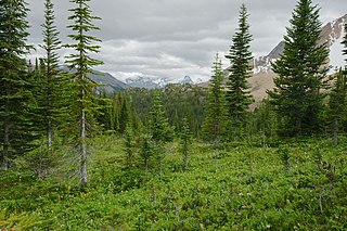
The Montane Cordillera Ecozone, as defined by the Commission for Environmental Cooperation (CEC), is an ecozone in south-central British Columbia and southwestern Alberta, Canada. A rugged and mountainous ecozone spanning 473,000 square kilometres, it still contains "two of the few significant agricultural areas of the province", the Creston Valley and the Okanagan Valley. Primarily a mountainous region, it consists of rugged ecosystems such as alpine tundra, dry sagebrush and dense conifer forests. The interior plains are encircled by a ring of mountains. The area has a mild climate throughout the year, with typically dry summers and wet winters.
The Duncan River is in the West Kootenay region of southeastern British Columbia. Entering the North Arm of Kootenay Lake, the river is a major tributary of the Kootenay River, which in turn flows into the Columbia River. The Selkirk Mountains lie to the west and the Purcell Mountains to the east.
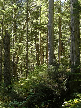
The Incomappleux River is in the West Kootenay region of southeastern British Columbia, Canada. Entering the Beaton Arm of Upper Arrow Lake, the river is a major tributary of the Columbia River. The upper reaches of the Incomappleux valley are home to some of the only inland temperate rainforest in the world.
Toby Glacier is a glacier in the Purcell Mountains of southeastern British Columbia, Canada. It covers an area of 123 square kilometres (47 sq mi). Its main drainage basin is Toby Creek. It is located within Purcell Wilderness Conservancy Provincial Park and Protected Area.

Foster Peak is a 3,204-metre (10,512-foot) mountain summit located on the western border of Kootenay National Park. It is the highest point in the Vermilion Range, a sub-range of the Canadian Rockies of British Columbia, Canada. Its nearest higher peak is Mount Ball, 14.96 km (9.30 mi) to the northeast. The mountain is part of what is known as The Rockwall. Floe Lake, southeast of the peak, is one of the beauty spots of Kootenay National Park. The area is accessible via the Floe Lake Trail and Rockwall Trail. The Rockwall Trail is a scenic 55 kilometre traverse of alpine passes, subalpine meadows, hanging glaciers, and limestone cliffs, in some places in excess of 900 metres above the trail.

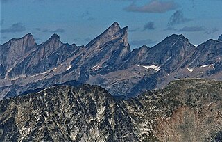
Archduke Mountain is a 3,135-metre (10,285-foot) mountain summit located in the Purcell Mountains of British Columbia, Canada. It is situated 43 km (27 mi) north of Kaslo, on the northern boundary of Purcell Wilderness Conservancy Provincial Park and Protected Area. The nearest peak is Emperor Peak, 1 km (0.62 mi) to the west. These two peaks make up the double summit of the Archduke-Emperor massif. The mountain's name was officially adopted June 20, 1972, when approved by the Geographical Names Board of Canada. The mountain's name was submitted by climber Dr. Curt Wagner for Beethoven's Archduke Trio, which was dedicated to Archduke Rudolf of Austria.
Emperor Peak is a 3,127-metre (10,259-foot) mountain summit located in the Purcell Mountains of British Columbia, Canada. It is situated 43 km (27 mi) north of Kaslo, on the northern boundary of Purcell Wilderness Conservancy Provincial Park and Protected Area. The nearest higher peak is Archduke Mountain, one km (0.62 mi) to the east. These two peaks make up the double summit of the Archduke-Emperor massif. The mountain's name was officially adopted June 20, 1972, when approved by the Geographical Names Board of Canada. The peak was named for its regal appearance, and for Beethoven's Emperor Concerto, as submitted by climber Curt Wagner who had climbed the mountain in 1967.

Truce Mountain is a 3,262-metre (10,702-foot) glaciated mountain summit located in the Purcell Mountains of British Columbia, Canada. It is situated 46 km (29 mi) north of Kaslo, on the northern boundary of Purcell Wilderness Conservancy Provincial Park and Protected Area. The nearest higher peak is Mount Hamill, 11 km (6.8 mi) to the southeast. Other nearby peaks include Mount Macbeth, 11 km (6.8 mi) to the northwest, and Archduke Mountain, 6 km (3.7 mi) to the west. The first ascent of Truce Mountain was made August 9, 1916, by Conrad Kain, H. Otto Frind, Elise Hopkins, Albert H. MacCarthy, Elizabeth MacCarthy, Margaret Stone, Winthrop E. Stone, Mrs. George E. Vincent, and John Vincent. The mountain's name was officially adopted June 9, 1960, when approved by the Geographical Names Board of Canada.

Mount Earl Grey is a 3,149-metre (10,331-foot) mountain summit located in the Purcell Mountains of British Columbia, Canada. It is situated 42 km (26 mi) southwest of Invermere, and 52 km (32 mi) north-northeast of Kaslo, on the northern boundary of Purcell Wilderness Conservancy Provincial Park and Protected Area. Nearby peaks include Truce Mountain, 12 km (7.5 mi) to the west, Redtop Mountain, 1.5 km (0.93 mi) to the southwest, and Jumbo Mountain, 8.5 km (5.3 mi) to the north. The mountain was named in 1915 in association with Earl Grey Pass which is 8 km (5.0 mi) south of the mountain. In turn, the pass was named for Albert Grey, 4th Earl Grey (1851-1917), the Governor General of Canada from 1904 through 1911, who visited this pass during horseback camping trips in 1907 and 1908. The mountain's name was officially adopted March 31, 1924, when approved by the Geographical Names Board of Canada. The first ascent of Mount Earl Grey was made July 16, 1928, by E. Cromwell, J. G. Hillhouse, J. Monroe Thorington, and Conrad Kain.

Redtop Mountain is a 3,156-metre (10,354-foot) mountain summit located in the Purcell Mountains of British Columbia, Canada. It is situated 44 km (27 mi) southwest of Invermere, and 49 km (30 mi) north-northeast of Kaslo, on the northern boundary of Purcell Wilderness Conservancy Provincial Park and Protected Area. Nearby peaks include Truce Mountain, 10 km (6.2 mi) to the west, Mount Earl Grey, 1.5 km (0.93 mi) to the northeast, and Jumbo Mountain, 10 km (6.2 mi) to the north. The first ascent of Redtop Mountain was made August 11, 1916, by Albert H. MacCarthy, Elizabeth MacCarthy, and Conrad Kain. Albert MacCarthy would go on to lead the 1925 first ascent of Mount Logan, Canada's highest mountain. The mountain's name was officially adopted June 9, 1960, when approved by the Geographical Names Board of Canada.
Hall Peak is a 3,048-metre (10,000-foot) mountain summit located in British Columbia, Canada.

