
Gulf Islands National Park Reserve is a national park located on and around the Gulf Islands in British Columbia, Canada. In the National Parks System Plan, this park provides representation of the Strait of Georgia Lowlands natural region, the only place in Canada with a Mediterranean climate of dry, sunny summers and mild, wet winters, the result of a rain shadow effect from surrounding mountains between the region and the ocean. It has similar dominant vegetation as the Pacific Northwest, such as coastal Douglas-fir, western red cedar, shore pine, Pacific dogwood, bigleaf maple, and red alder, but also contains the northern extent of some of the more drought tolerant trees such as Garry oak and Arbutus. The park was created in 2003 as the fortieth national park. It covers 36 square kilometres (14 sq mi) of area on 16 islands and more than 30 islets, reefs and surrounding waters, making it the sixth smallest national park in Canada.

Hazelton is a village municipality in the Skeena region of west central British Columbia, Canada. The place is on the southeast side of the Skeena River immediately north of the Bulkley River mouth, where the confluence forms a peninsula. On BC Highway 62, the locality is by road about 75 kilometres (47 mi) northwest of Smithers and 144 kilometres (89 mi) northeast of Terrace. Hazelton is the original of the "Three Hazeltons", the other two being New Hazelton to the southeast and South Hazelton to the south.

Lake Nipigon is part of the Great Lakes drainage basin. It is the largest lake entirely within the boundaries of the Canadian province of Ontario.
Adams Lake is a deep, cold-water lake in south-central British Columbia, which separates the Thompson and Shuswap regions and the Thompson–Nicola and Columbia–Shuswap regional districts. The upper reaches lie in the northern Monashee Mountains, while the lower end penetrates the Shuswap Highland. The southern end is by road about 79 kilometres (49 mi) northeast of Kamloops.
Fort Babine is an unincorporated community that borders the Skeena and Omineca regions of central British Columbia. This First Nations settlement is on the east shore of the Babine River at the northern tip of Babine Lake. By road, the location is about 105 kilometres (65 mi) northeast of Smithers.
Babine Mountains Provincial Park is a provincial park in British Columbia, Canada, located to the east of the Bulkley River between the town of Smithers and Babine Lake. Established by Order-in-Council as the Babine Mountains Recreation Area in 1984, it was upgraded to park status and its name changed in 1999. It contains approximately 31,465 hectares.
Kitsumkalum Park is in the Skeena region of west central British Columbia, Canada. This provincial park is on the east shore of the Kitsumkalum River at the foot of Kitsumkalum Lake. On Kalum Lake Road, the locality is by road about 29 kilometres (18 mi) north of Terrace.
Lava Forks Provincial Park is a provincial park in northern British Columbia, Canada. It is the site of Canada's most recent volcanic eruption, which occurred around 1904 at Lava Fork.

Miracle Beach Provincial Park is a provincial park on the eastern shore of Vancouver Island in British Columbia, Canada. Located between Comox and Campbell River, the park includes a foreshore area in the Strait of Georgia, much of the Black Creek estuary, and a forested area. According to its Master Plan, it fulfills primarily a recreational role with a focus on beach play, picnicking, nature appreciation, and camping, and a secondary conservation role with a focus on the natural shoreline and estuary. In support of its recreational focus the park is developed with a day-use parking area with accessible trails leading to the shoreline and a camping area with 200 drive-in sites. The park is also hosts a nature centre building and a sheltered group picnic shelter. Vegetation in the park is typical for the region's second-growth forests with Douglas-fir most prominent. Common associates include Western hemlock, Sitka spruce, red alder and bigleaf maple. Salal and sword fern are the most abundant shrub. Black Creek, which flows through the park, is a spawning area for coho salmon.

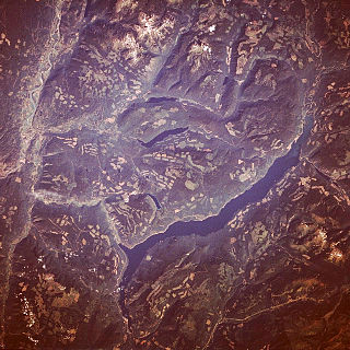
Babine Lake borders the Skeena and Omineca regions of central British Columbia, Canada. Vehicle access to the lake, via BC Highway 16 and Nilkitkwa forestry service road, is by road about 105 kilometres (65 mi) northeast of Smithers; via BC Highway 16 and Central Babine Lake Highway, is about 132 kilometres (82 mi) east of Smithers; or via Babine Lake Road, is about 20 kilometres (12 mi) northeast of Burns Lake.

Sechelt Inlets Marine Provincial Park is a provincial park in British Columbia, Canada, that protects six separate sites along three inlets north of the city of Sechelt. The six sites are located at various locations on Sechelt Inlet and its two side arms, Salmon Inlet and Narrows Inlet. Established initially as a recreation area in 1980, it was converted to a park in 1999, consisting of approximately 140 hectares in total.

BC Parks is an agency of the British Columbia Ministry of Environment and Climate Change Strategy that manages all of the, as of 2020, 1,035 provincial parks and other conservation and historical properties of various title designations within the province's Parks oversaw of the British Columbia Parks and Protected Areas System. The Lieutenant Governor-in-Council created the agency on March 1, 1911, through the Strathcona Park Act. The agency is charged with a dual role of preserving the ecological and historical integrity of the places entrusted to its management, while also making them available and accessible for public use and enjoyment.
Babine Portage borders the Skeena and Omineca regions of central British Columbia. The portage linked Babine Lake and Stuart Lake, and lies between the Yekooche First Nation reserves of Nan tl' at 13 and Ye koo che 13. By road, the location is about 80 kilometres (50 mi) northwest of Fort St. James.
Lake Babine Nation is a Babine band government, historically located on the banks of Babine Lake in central British Columbia, Canada. Its main community has been in Woyenne, near Burns Lake, since many of the nation's members moved there in the 1940s. Other year-round communities include Tachet on the central part of Babine Lake and Wit'at at the end of the northwest arm of the lake. Seasonal communities include Nedo'ats at the north end of the lake and Donald's Landing toward the south end.
Monte Creek is an unincorporated community in the Thompson region of south central British Columbia. The former ferry landing is east of the mouth of Monte Creek and on the south shore of the South Thompson River. Immediately west of the BC Highway 97 intersection on BC Highway 1, the locality is by road about 30 kilometres (19 mi) west of Chase and 28 kilometres (17 mi) east of Kamloops.
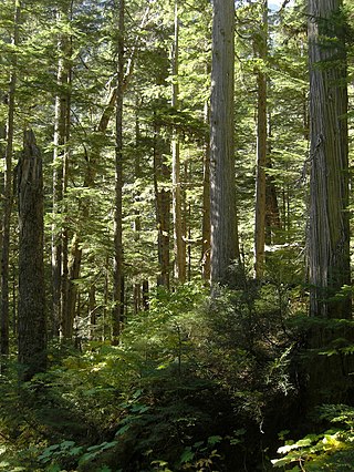
The Incomappleux River is in the West Kootenay region of southeastern British Columbia, Canada. Entering the Beaton Arm of Upper Arrow Lake, the river is a major tributary of the Columbia River. The upper reaches of the Incomappleux valley are home to some of the only inland temperate rainforest in the world.

Mara Lake is a lake in the Shuswap Country region of south central British Columbia, Canada. To the west is Hyde Mountain and east is Morton Peak. The outlet of the Shuswap River forms the upper reaches. The lower end enters the narrows at Sicamous and flows into Shuswap Lake. The northern end of Mara Lake is by road about 73 kilometres (45 mi) west of Revelstoke, 140 kilometres (87 mi) east of Kamloops, and 75 kilometres (47 mi) north of Vernon.

The Germansen River is in the Omineca region of central British Columbia, Canada. Flowing through Germansen Lake, the river is a major tributary of the Omenica River, which in turn enters Williston Lake. Surrounded by the spread of the Swannell Ranges, the lake is south of Plughat Mountain and north of the Germansen Range, which contains Mount Germansen.
The Lardeau River, which flows into the Duncan River, is in the West Kootenay region of southeastern British Columbia. The Selkirk Mountains lie to the west and the Purcell Mountains to the east.
Firvale is an unincorporated community in the Bella Coola Valley region of west central British Columbia, Canada. On the north shore of the Bella Coola River about 6 kilometres (4 mi) west of the mouth of Burnt Bridge Creek, no link exists to the former centre on the south shore. On BC Highway 20, the locality is by road about 412 kilometres (256 mi) west of Williams Lake and 41 kilometres (25 mi) east of Bella Coola.

