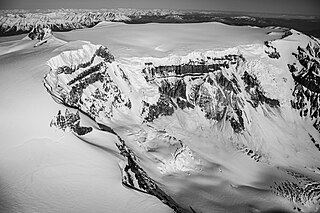
Mount Edziza is a volcanic mountain in Cassiar Land District of northwestern British Columbia, Canada. It is located on the Big Raven Plateau of the Tahltan Highland which extends along the western side of the Stikine Plateau. Mount Edziza has an elevation of 2,786 metres, making it the highest point of the Mount Edziza volcanic complex and one of the highest volcanoes in Canada. However, it had an elevation of at least 3,396 metres before its formerly cone-shaped summit was likely destroyed by a violent eruption in the geologic past; its current flat summit contains an ice-filled, 2-kilometre-in diameter (1.2-mile) crater. The mountain contains several lava domes, cinder cones and lava fields on its flanks, as well as an ice cap containing several outlet glaciers which extend to lower elevations. All sides of Mount Edziza are drained by tributaries of Mess Creek and Kakiddi Creek which are situated within the Stikine River watershed.
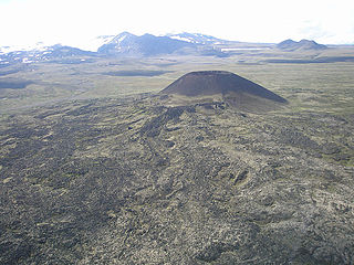
Eve Cone, sometimes referred to as Eve's Cone, is a cinder cone in Cassiar Land District of northwestern British Columbia, Canada. It has an elevation of 1,740 metres and is one of several volcanic cones in the Desolation Lava Field at the northern end of the Big Raven Plateau. The cone is southeast of the community of Telegraph Creek in Mount Edziza Provincial Park, which is one of the largest provincial parks in British Columbia. The climate in the area is characterized by warm summers and cold, snowy winters. However, temperatures can drop below freezing during summer nights, making snow or freezing rain a possibility at any time of the year.

The Spectrum Range, formerly gazetted as the Spectrum Mountains and the Rainbow Mountains, is a small mountain range in Cassiar Land District of northwestern British Columbia, Canada. Located at the southern end of the Tahltan Highland, it borders the Skeena Mountains in the east and the Boundary Ranges of the Coast Mountains in the west. The Spectrum Range is surrounded by the Arctic Lake Plateau in the southwest and the Kitsu Plateau in the northwest, both of which contain volcanic features such as cinder cones. It lies at the southern end of the Mount Edziza volcanic complex which includes the two neighbouring plateaus, as well as Mount Edziza and the Big Raven Plateau to the north. The mountain range is drained on all sides by streams within the Stikine River watershed and, unlike Mount Edziza to the north, contains relatively small separate glaciers. Mount Edziza Provincial Park is the main protected area surrounding the Spectrum Range.

Coffee Crater is a cinder cone in Cassiar Land District of northwestern British Columbia, Canada. It has an elevation of 2,000 metres and is one of several volcanic cones in the Snowshoe Lava Field at the southern end of the Big Raven Plateau. The cone is southeast of the community of Telegraph Creek in Mount Edziza Provincial Park, which is one of the largest provincial parks in British Columbia. The climate in the area is characterized by warm summers and cold, snowy winters. However, temperatures can drop below freezing during summer nights, making snow or freezing rain a possibility at any time of the year.
Sidas Cone is a cinder cone on the Big Raven Plateau at the northern end of Mount Edziza Provincial Park in British Columbia, Canada. Its name, meaning "cut oneself with a knife" in the Tahltan language, is descriptive of the breach that has cut the cone into two symmetrical halves.
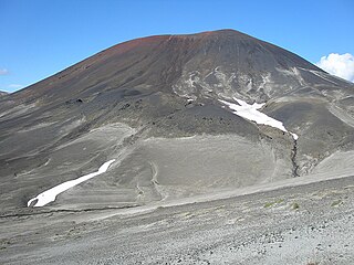
Cocoa Crater, sometimes called Cocoa Cone, is a cinder cone in Cassiar Land District of northwestern British Columbia, Canada. It has an elevation of 2,117 metres and is one of several volcanic cones in the Snowshoe Lava Field at the southern end of the Big Raven Plateau. The cone is southeast of the community of Telegraph Creek in Mount Edziza Provincial Park, which is one of the largest provincial parks in British Columbia. The climate in the area is characterized by warm summers and cold, snowy winters. However, temperatures can drop below freezing during summer nights, making snow or freezing rain a possibility at any time of the year.

Ice Peak is the prominent south peak of Mount Edziza in Cassiar Land District of northwestern British Columbia, Canada. It has an elevation of 2,500 metres and protrudes through Mount Edziza's ice cap, which is roughly 70 square kilometres in area. The peak is a pyramid-shaped horn formed by glacial erosion and is completely flanked by steep-walled, active cirques. Tencho Glacier on the southern flank is the largest outlet glacier of Mount Edziza's ice cap. The summit of Ice Peak is about 280 metres lower than that of Mount Edziza, but it still rises well above the general level of the Big Raven Plateau. Ice Peak and the surrounding area are in Mount Edziza Provincial Park, which also includes the Spectrum Range to the south.

Nahta Cone is a small cinder cone in Cassiar Land District of northwestern British Columbia, Canada. It has an elevation of 1,670 metres and lies near the northern edge of the Arctic Lake Plateau, a glacially scored plateau of the Tahltan Highland which in turn extends along the western side of the Stikine Plateau. The cone is about 70 kilometres south-southeast of the community of Telegraph Creek and lies in the southwestern corner of Mount Edziza Provincial Park, one of the largest provincial parks in British Columbia.
Wetalth Ridge is an isolated ridge in northern British Columbia, Canada, located 74 km (46 mi) southwest of Tatogga and south of Telegraph Creek. It lies on the southwest side of Little Arctic Lake at the southwest corner of Mount Edziza Provincial Park.

Pillow Ridge is a ridge of the Tahltan Highland in northern British Columbia, Canada, located southeast of Telegraph Creek. It extends northwest from Mount Edziza in Mount Edziza Provincial Park.
Outcast Hill is an isolated hill in northern British Columbia, Canada, located southeast of Mess Lake. It lies at the southern end of Mount Edziza Provincial Park.

The Big Raven Plateau is an intermontane plateau in Cassiar Land District of northwestern British Columbia, Canada. It lies on the Tahltan Highland and is surrounded by several valleys, including those of Mess Creek, Kakiddi Creek, Chakima Creek, Walkout Creek and the Klastline River. The plateau is drained by many small streams that flow into these neighbouring valleys and, unlike the valleys, it is relatively barren of vegetation. Stream erosion has resulted in the creation of canyons with intervening ridges on the eastern and western sides of the plateau, resulting in the creation of rugged terrain. The plateau is in Mount Edziza Provincial Park which is one of the largest provincial parks in British Columbia. Access to the Big Raven Plateau is mainly by aircraft or by a network of footpaths from surrounding roads.

Tennena Cone, alternatively Icebridge Cone, is a small volcanic cone in Cassiar Land District of northwestern British Columbia, Canada. It has an elevation of 2,390 metres and lies on the upper western flank of Ice Peak, the prominent south peak of Mount Edziza. The cone is almost completely surrounded by Mount Edziza's ice cap and is one of several volcanoes in the Snowshoe Lava Field on the Big Raven Plateau. Tennena Cone is 200 metres high, 1,200 metres long and up to 600 metres wide, its symmetrical structure resembling a black pyramid. The cone and the surrounding area are in Mount Edziza Provincial Park which also includes the Spectrum Range to the south.

The Mount Edziza volcanic complex is a group of volcanoes and associated lava flows in northwestern British Columbia, Canada. Located on the Tahltan Highland, it is 40 kilometres southeast of Telegraph Creek and 85 kilometres southwest of Dease Lake. The complex encompasses a broad, steep-sided lava plateau that extends over 1,000 square kilometres. Its highest summit is 2,786 metres in elevation, making the MEVC the highest of four large complexes in an extensive north–south trending volcanic region. It is obscured by an ice cap characterized by several outlet glaciers that stretch out to lower altitudes.
Exile Hill is an isolated hill in the Spectrum Range of northern British Columbia, Canada, located southeast of Mess Lake. It lies at the southern end of Mount Edziza Provincial Park.

The Volcano, also known as Lava Fork volcano, is a small cinder cone in the Boundary Ranges of the Coast Mountains in northwestern British Columbia, Canada. It is located approximately 60 km (40 mi) northwest of the small community of Stewart near the head of Lava Fork. With a summit elevation of 1,656 m (5,433 ft) and a topographic prominence of 311 m (1,020 ft), it rises above the surrounding rugged landscape on a remote mountain ridge that represents the northern flank of a glaciated U-shaped valley.

The volcanic history of the Northern Cordilleran Volcanic Province presents a record of volcanic activity in northwestern British Columbia, central Yukon and the U.S. state of easternmost Alaska. The volcanic activity lies in the northern part of the Western Cordillera of the Pacific Northwest region of North America. Extensional cracking of the North American Plate in this part of North America has existed for millions of years. Continuation of this continental rifting has fed scores of volcanoes throughout the Northern Cordilleran Volcanic Province over at least the past 20 million years and occasionally continued into geologically recent times.
The Mount Edziza volcanic complex (MEVC) in British Columbia, Canada, has a history of volcanism that spans more than 7 million years. It has taken place during five cycles of magmatic activity, each producing less volcanic material than the previous one. Volcanism during these cycles has created several types of volcanoes, including cinder cones, stratovolcanoes, subglacial volcanoes, shield volcanoes and lava domes. The roughly 1,000-square-kilometre (400-square-mile) volcanic plateau forming the base of the MEVC originated from the successive eruptions of highly mobile lava flows. Volcanic rocks such as basalt, trachybasalt, benmoreite, tristanite, mugearite, trachyte and rhyolite were deposited by multiple eruptions of the MEVC; the latter six rock types are products of varying degrees of magmatic differentiation in underground magma reservoirs. Renewed effusive volcanism could block local streams with lava flows whereas renewed explosive volcanism could disrupt air traffic with volcanic ash across parts of northwestern Canada. At least 10 distinct flows of obsidian were produced by volcanism of the MEVC, some of which were exploited by indigenous peoples in prehistoric times to make tools and weaponry.
The Edziza Formation is a stratigraphic unit of Pleistocene age in northwestern British Columbia, Canada. First described in 1984, the Edziza Formation was mapped as one of several geological formations of the Mount Edziza volcanic complex. It overlies at least four other geological formations of this volcanic complex that differ in age and composition. The main volcanic rock comprising the Edziza Formation is trachyte which was deposited by volcanic eruptions at the end of the third magmatic cycle of the Mount Edziza volcanic complex 0.9 million years ago.


