
Ornostay Bluff is a volcanic bluff in northern British Columbia, Canada, located just southwest of Mount Edziza in Mount Edziza Provincial Park and southeast of Telegraph Creek. [1]
Ornostay Bluff is a volcanic bluff in northern British Columbia, Canada, located just southwest of Mount Edziza in Mount Edziza Provincial Park and southeast of Telegraph Creek. [1]
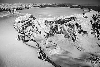
Mount Edziza is a volcanic mountain in Cassiar Land District of northwestern British Columbia, Canada. It is located on the Big Raven Plateau of the Tahltan Highland which extends along the western side of the Stikine Plateau. Mount Edziza has an elevation of 2,786 metres, making it the highest point of the Mount Edziza volcanic complex and one of the highest volcanoes in Canada. However, it had an elevation of at least 3,396 metres before its formerly cone-shaped summit was likely destroyed by a violent eruption in the geologic past; its current flat summit contains an ice-filled, 2-kilometre-in diameter (1.2-mile) crater. The mountain contains several lava domes, cinder cones and lava fields on its flanks, as well as an ice cap containing several outlet glaciers which extend to lower elevations. All sides of Mount Edziza are drained by tributaries of Mess Creek and Kakiddi Creek which are situated within the Stikine River watershed.

The Big Raven Plateau is an intermontane plateau in Cassiar Land District of northwestern British Columbia, Canada. It lies on the Tahltan Highland and is surrounded by several valleys, including those of Mess Creek, Kakiddi Creek, Chakima Creek, Walkout Creek and the Klastline River. The plateau is drained by many small streams that flow into these neighbouring valleys and, unlike the valleys, it is relatively barren of vegetation. Stream erosion has resulted in the creation of canyons with intervening ridges on the eastern and western sides of the plateau, resulting in the creation of rugged terrain. The plateau is in Mount Edziza Provincial Park which is one of the largest provincial parks in British Columbia. Access to the Big Raven Plateau is mainly by aircraft or by a network of footpaths from surrounding roads.

Koosick Bluff is a volcanic bluff in Cassiar Land District in northern British Columbia, Canada. It is located in Mount Edziza Provincial Park, just northwest of Cocoa Crater and southwest of Mount Edziza.
Kana Cone is a red nested cinder cone in northern British Columbia, Canada, located northeast of Eve Cone in Mount Edziza Provincial Park. The name of the cone was adopted 2 January 1980 on National Topographic System map 104G/12 after being submitted to the BC Geographical Names office by the Geological Survey of Canada, although the cone was labelled as Ashwell Cone on a 1988 Geological Survey of Canada map by Canadian volcanologist Jack Souther.

Tennena Cone, alternatively Icebridge Cone, is a small volcanic cone in Cassiar Land District of northwestern British Columbia, Canada. It has an elevation of 2,390 metres and lies on the western flank of Ice Peak, the prominent south peak of Mount Edziza. The cone is almost completely surrounded by glacial ice of Mount Edziza's ice cap which covers an area of around 70 square kilometres. Tennena Cone is 200 metres high, 1,200 metres long and up to 600 metres wide, its symmetrical structure resembling a black pyramid. The cone and the surrounding area are in Mount Edziza Provincial Park which also includes the Spectrum Range to the south.
Cinder Cliff is a cinder cone in northern British Columbia, Canada. It is thought to have last erupted during the Holocene period and is part of the Mount Edziza volcanic complex.
Icefall Cone is a cinder cone in northern British Columbia, Canada. It is thought to have last erupted during the Holocene period and forms part of the Mount Edziza volcanic complex.
Ridge Cone is a cinder cone in northern British Columbia, Canada. It is thought to have last erupted in the Holocene period and is part of the Mount Edziza volcanic complex.
Moraine Cone is a cinder cone in northern British Columbia, Canada. It is thought to have last erupted in the Holocene period and is part of the Mount Edziza volcanic complex.
The Triplex Cones are a group of three cinder cones in northern British Columbia, Canada. They are thought to have last erupted during the Holocene epoch.
Cache Hill is a cinder cone in northern British Columbia, Canada. It is thought to have last erupted in the Holocene period. Once used as an airdrop for food and supplies by the Geological Survey of Canada, hence its name, it is located north of Raspberry Pass in Mount Edziza Provincial Park.
Sezill Volcano is a lava dome in Mount Edziza Provincial Park of northern British Columbia, Canada. It is thought to have formed and last erupted during the Miocene period. The volcano gets its name from being adjacent to Sezill Creek.
Keda Cone, sometimes mistakenly called Kena Cone and sometimes referred to by the numeronym SLF-9, is a cinder cone in northwestern British Columbia, Canada. It is located in the Snowshoe Lava Field of Mount Edziza Provincial Park, having last erupted during the Holocene epoch.
Klastline Cone is a cinder cone in northwestern British Columbia, Canada, located near Mount Edziza in Mount Edziza Provincial Park. It last erupted during the Pleistocene epoch.
Pharaoh Dome is a lava dome in northwestern British Columbia, Canada, located near Mount Edziza in Mount Edziza Provincial Park. It last erupted during the Pleistocene epoch.
Nanook Dome is a lava dome in northwestern British Columbia, Canada, located just northeast of Mount Edziza in Mount Edziza Provincial Park. It last erupted during the Pleistocene epoch.
Sphinx Dome is a lava dome in northwestern British Columbia, Canada, located near Mount Edziza in Mount Edziza Provincial Park. It last erupted during the Pleistocene epoch.
Glacier Dome is a lava dome in northwestern British Columbia, Canada, located near Mount Edziza in Mount Edziza Provincial Park. It last erupted during the Pleistocene epoch.
Obsidian Ridge is a volcanic mountain ridge in northwestern British Columbia, Canada, located on the south side of Artifact Creek at the southeast end of Mount Edziza Provincial Park. It was named on January 2, 1980 by the Geological Survey of Canada for its high quality obsidian. Because of its high obsidian content, it was a source for tool making by the local Tahltan people.
Sezill Creek is a tributary of Taweh Creek, which in turn is a tributary of Mess Creek, part of the Stikine River watershed in northwest part of the province of British Columbia, Canada. It flows generally northwest for roughly 12 km (7.5 mi) to join Taweh Creek about 5 km (3.1 mi) east of Taweh Creek's confluence with Mess Creek. Sezill means "it is hot" in the Tahltan language, referring to a group of hot springs that occur along the creek.
57°41′59″N130°42′14″W / 57.6997°N 130.7039°W
| | This article about a location in the Interior of British Columbia, Canada is a stub. You can help Wikipedia by expanding it. |