Edziza Formation

Last updated

Edziza Formation
Stratigraphic range: Pleistocene
2.58–0.0118  Ma
O
S
D
C
P
T
J
K
Pg
N
Edziza042909-- 113-16.jpg
The ice-filled summit crater of Mount Edziza
Type Geological formation [1]
Unit of Mount Edziza volcanic complex [2]
Underlies Big Raven Formation [3]
OverliesPillow Ridge Formation, Ice Peak Formation, Pyramid Formation, Nido Formation [3] [4]
Lithology
Primary Trachyte [1]
Location
Coordinates 57°43′N130°38′W / 57.72°N 130.63°W / 57.72; -130.63 [5]
Region British Columbia [5]
CountryCanada [5]
Type section
Named for Mount Edziza [1]
Named by Souther et al., 1984 [6]
Edziza Formation
Location in Mount Edziza Provincial Park

The Edziza Formation is a stratigraphic unit of Pleistocene age in northwestern British Columbia, Canada. First described in 1984, the Edziza Formation was mapped as one of several geological formations of the Mount Edziza volcanic complex. It overlies at least four other geological formations of this volcanic complex that differ in age and composition. The main volcanic rock comprising the Edziza Formation is trachyte which was deposited by volcanic eruptions at the end of the third magmatic cycle of the Mount Edziza volcanic complex 0.9 million years ago.

Contents

Trachyte of the Edziza Formation is in the form of lava flows and pyroclastic rocks that comprise the central stratovolcano of Mount Edziza, as well as lava domes on its summit and flanks. At least four lava lakes ponded inside the summit crater which cooled into four rock units that are exposed in the breached eastern crater rim. These lava lakes overlie rock fragments inside the central volcanic conduit which accompanied with collapse of a narrower and higher summit.

Etymology

A number of explanations have been made regarding the origin of the name Edziza. A 1927 report by J. Davidson of the British Columbia Land Surveyors claims that Edziza means "sand" in the Tahltan language, referring to the deep volcanic ash deposits or pumice-like sand covering large portions of the Big Raven Plateau around Mount Edziza. According to David Stevenson of University of Victoria's Anthropology Department, "sand" or "dust" is instead translated as "kutlves" in the Tahltan language. An explanation listed in the BC Parks brochure is that Edziza means "cinders" in the Tahltan language. Another explanation proposed by Canadian volcanologist Jack Souther is that Edziza is a corruption of Edzerza, the name of a local Tahltan family. [7]

History

The Edziza Formation was first described by Jack Souther, Richard Lee Armstrong and J. Harakal in 1984 who grouped it together with the Pillow Ridge Formation in their descriptions and mapping. [6] [8] It was mapped as one of 15 geological formations of the Mount Edziza volcanic complex, a group of late Cenozoic volcanic rocks in northwestern British Columbia, Canada. [2] [8] In 1988, Jack Souther mapped the Edziza and Pillow Ridge formations separately and the number of geological formations comprising the Mount Edziza volcanic complex had dropped to 13; the Sheep Track and Kounugu formations had been reassigned as members of the Big Raven and Nido formations, respectively, and are no longer recognized. [3] [9] [10]

Location

Nearly all of the Edziza Formation is located on the east-central edge of the Big Raven Plateau, a barren plateau in Cassiar Land District bounded on the west by Mess Valley, on the north by Klastline Valley, on the east by Kakiddi Valley and on the south by Chakima and Walkout valleys, the latter two of which are separated by mountainous terrain. [3] [11] [12] It lies at the northern end of the Mount Edziza volcanic complex which also includes the smaller Arctic Lake and Kitsu plateaus to the south. [13] This complex of shield volcanoes, stratovolcanoes, lava domes, calderas and cinder cones forms a broad, intermontane plateau at the eastern edge of the Tahltan Highland, a southeast-trending upland area extending along the western side of the Stikine Plateau. [12] [14] [15] Small portions of the Edziza Formation occur north, northwest and southwest of Nuttlude Lake which is an expansion of Kakiddi Creek. [3] [16]

Stratigraphy

Mount Edziza as seen from Mount Glenora in the northwest Mount Edziza from Mount Glenora2.jpg
Mount Edziza as seen from Mount Glenora in the northwest

Stratigraphically, the Edziza Formation is the fifth youngest unit of the Mount Edziza volcanic complex, having been deposited over the Nido, Pyramid, Ice Peak and Pillow Ridge formations. [2] [3] [4] It has a volume of 18 cubic kilometres (4.3 cubic miles), making it the fifth most voluminous geological formation of the Mount Edziza volcanic complex. The Edziza Formation is also the youngest geological formation of the Mount Edziza volcanic complex involving more than 10 cubic kilometres (2.4 cubic miles) of volcanic material. [2]

Basalt flows of the 4.4 million-year-old Nido Formation are overlain by the Edziza Formation on the eastern flank of Mount Edziza between Tenchen Creek and The Pyramid where they overlie a ridge of Mesozoic basement rocks. [2] [17] The Edziza Formation overlies the westernmost portion of Sphinx Dome, a rhyolite dome of the 1.1 million-year-old Pyramid Formation; two thick remnants of the Edziza Formation also occur on the steep northern and southern flanks of this dome. [2] [18]

Basalt flows of the roughly one million-year-old Ice Peak Formation are overlain by the Edziza Formation which overlaps with the northern flank of Ice Peak. [2] [8] [19] The 0.9 million-year-old Pillow Ridge Formation is sparsely overlain by the Edziza Formation, but much larger portions of the Edziza Formation overlap with the western and northern edges of Pillow and Tsekone ridges, respectively. [2] [3] [20] Hawaiite and patches of air-fall tephra assigned to the Holocene Big Raven Formation overlie the northern end of the Edziza Formation where they are part of the Desolation Lava Field. [3] [5]

Lithology

The Edziza Formation consists mainly of trachyte that was erupted 0.9 million years ago at the end of the third magmatic cycle of the Mount Edziza volcanic complex. [21] Its composition straddles near the pantelleritic trachyte/comenditic trachyte boundary and is in the form of explosion breccias, lava flows and lava domes. The trachyte contains a matrix of sodic plagioclase alkali feldspar, katophorite, arfvedsonite, aenigmatite and opaque oxides that is embedded with sparse phenocrysts of anorthoclase and sodic ferrohedenbergite. Edziza trachyte is mineralogically similar to trachyte of the Kakiddi Formation which was erupted 0.3 million years ago during the final stages of the fourth magmatic cycle. However, the Kakiddi trachyte flows travelled along gently sloping valleys for at least 10 kilometres (6.2 miles), suggesting that they were erupted more fluidly than those of the Edziza Formation. [8]

Stratovolcano

The main feature consisting of Edziza Formation trachyte is the central stratovolcano of Mount Edziza. [1] It comprises explosion breccias, landslide or lahar deposits and thick, steeply-dipping flows that were erupted as highly viscous lava. [22] These rocks are well-exposed in 850-metre-high (2,790-foot) cliffs on the eastern flank of Mount Edziza where they occur along the north side of Tenchen Valley. This section of the stratovolcano contains a lower assemblage of chaotic explosion breccias and an upper assemblage of lava that overlies the breccias. [23] Lava of the upper assemblage is highly irregular or lenticular in cross section, but it contains individual cooling units as much as 150 metres (490 feet) thick. [24]

Summit of Mount Edziza Mount Edziza summit.jpg
Summit of Mount Edziza

The lower assemblage encloses up to 120-metre-long (390-foot) and 15-metre-thick (49-foot) lavas that occur as relatively small, crudely-jointed, irregular masses and discontinuous lenses. [1] Extremely coarse breccias occur in the western proximity and contain massive, up to 7.5-metre-wide (25-foot) volcanic blocks that were probably deposited directly from the central conduit during eruption. [23] At the eastern end of Tenchen Valley are more distal breccias that rarely contain volcanic blocks more than 1.5 metres (4.9 feet) wide. Local rounding and stratification of these breccias is indicative of lahar or landslide deposition. [24]

Exposed in the steep Tenchen cirque headwall are large volcanic blocks and small breccia fragments within the central conduit that accompanied with collapse of a narrower summit with a much smaller crater. [24] The collapse may have been caused by a violent, climactic eruption, effusion of the Kakiddi lava flows or the outpouring of voluminous lava during dome formation. Prior to collapse, the summit of Mount Edziza was at least 610 metres (2,000 feet) higher than it is today. [25]

Summit crater

The broad, nearly flat summit of Mount Edziza is truncated by a 3-kilometre-wide (1.9-mile) crater that formed after collapse of the original summit. [24] A circular ridge surrounding this ice-filled crater is partially exposed above the ice cap as a discontinuous series of spires and serrated nunataks. Spires forming the southern end of the ridge are the highest and consist of greenish grey, sparsely porphyritic trachyte. They comprise well-formed, small diameter rock columns that rise nearly vertically for more than 90 metres (300 feet) above the ice cap. Nunataks elsewhere on the summit ridge are more subdued, consisting of pyroclastic debris that has been glacially reworked. [1]

The remnants of several lava lakes are exposed inside the crater where the eastern side of the summit ridge has been breached by active cirques. [1] [14] They overlie breccia of the central conduit and are in the form of at least four cooling units. Trachyte with well-developed columnar jointing forms the lower two units, each of which is about 30 metres (98 feet) thick. The two upper units consist of lighter green trachyte; the lower unit has a thickness of nearly 90 metres (300 feet). Well-developed, vertical and rectangularly jointed trachyte forms this unit and comprises a shear cliff across the full width of the Tenchen cirque headwall. The uppermost unit is largely buried under overhanging ice, but it appears to consist of agglutinated volcanic blocks. [26]

Subvolcanic intrusions

Exposed in the underlying basement rocks on the deeply eroded eastern flank of Mount Edziza are subvolcanic trachyte cupolas, sills, dikes and irregular intrusive masses linked to the magma plumbing system. Dikes are present as swarms and are usually vertical or subvertical, having been distributed in a crudely radial pattern towards the summit crater. They individually range in thickness from a few centimetres to nearly 2 kilometres (1.2 miles) and occur both within the stratovolcano and in the underlying basement rocks. Cupolas occur throughout Tenchen Valley as 3-to-9-metre-wide (9.8-to-29.5-foot) projections through thick pyroclastic deposits and resemble inverted sand castings up to 12 metres (39 feet) high where the breccia has eroded away. [27]

Hydrothermal alteration

Mount Edziza from the northwest Mt Glenora Stikine Valley 20.jpg
Mount Edziza from the northwest

The Tenchen cirque headwall exposes dikes, sills and breccias within the central conduit that have been intensely altered by hydrothermal solutions, resulting in the rocks being bright yellow and ochre-weathered. Complete alteration occurs in the middle of the altered zone where rock has been reconstituted to a pure white, amorphous material; the only original mineral present is alkali feldspar which comprises small tabular phenocrysts. [27]

Permeating the completely altered material are chalcedony veinlets less than 1 millimetre (0.039 inches) thick which are cut by more extensively distributed veins 1 to 5 centimetres (0.39 to 1.97 inches) wide. Tiny cubes of pyrite occupy many of the larger veins while the surrounding wall rock contains disseminated pyrite and marcasite. The conduit breccia and surrounding rocks were likely altered by intense fumarolic activity that occurred on a prolonged basis. [27]

Subfeatures

At least three trachyte domes of the Edziza Formation occur on Mount Edziza, all of which were created by the rapid effusion of viscous trachytic lava. The nearly circular Nanook Dome forms the southeastern buttress of the summit crater and is the largest of the three lava domes with a diameter of about three-quarters of a kilometre. [28] It may have been the source for the two upper lava lakes inside the summit crater as they consist of trachyte similar to that of Nanook Dome. [29] Glacier Dome and Triangle Dome are two elliptical masses of trachyte with concentric flow layering on the northwestern and western flanks of Mount Edziza, respectively. [30] Triangle Dome displays a pattern of columnar cooling joints that indicates it was formed by volcanic activity in a subglacial environment. [31] A 24-metre-thick (79-foot) trachyte flow that may have issued during an early, fluid phase of the Glacier Dome eruption is exposed for 2 kilometres (1.2 miles) north of Pyramid Creek; its distal end thins to about 15 metres (49 feet). [32]

South of Pillow Ridge on the northwestern flank of Mount Edziza is a rounded pyroclastic cone with a small central crater that probably formed during the latter stages of Edziza Formation volcanism. [24] This pile of agglutinated trachyte spatter, pumice and bombs was the source of at least two separate lobes of lava that flowed onto the adjacent plateau surface. [33] The northwesterly lobe partially encircles Tsekone Ridge and borders as well as overlies breccia of Pillow Ridge. Extending west of the pyroclastic cone is the second lobe of lava which, together with the northwesterly lobe, is largely overlain by volcanic ash and colluvial material. [28]

See also

Related Research Articles

<span class="mw-page-title-main">Anahim Volcanic Belt</span> Chain of volcanoes and related magmatic features in British Columbia, Canada

The Anahim Volcanic Belt (AVB) is a west–east trending chain of volcanoes and related magmatic features in British Columbia, Canada. It extends from Athlone Island on the Central Coast, running eastward through the strongly uplifted and deeply dissected Coast Mountains to near the community of Nazko on the Interior Plateau. The AVB is delineated as three west-to-east segments that differ in age and structure. A wide variety of igneous rocks with differing compositions occur throughout these segments, comprising landforms such as volcanic cones, volcanic plugs, lava domes, shield volcanoes and intrusions.

<span class="mw-page-title-main">Hoodoo Mountain</span> Stratovolcano in British Columbia, Canada

Hoodoo Mountain, sometimes referred to as Hoodoo Volcano, is a potentially active stratovolcano in the Northern Interior of British Columbia, Canada. It is located 25 kilometres northeast of the Alaska–British Columbia border on the north side of the Iskut River opposite of the mouth of the Craig River. With a summit elevation of 1,850 metres and a topographic prominence of 900 metres, Hoodoo Mountain is one of many prominent peaks within the Boundary Ranges of the Coast Mountains. Its flat-topped summit is covered by an ice cap more than 100 metres thick and at least 3 kilometres in diameter. Two valley glaciers surrounding the northwestern and northeastern sides of the mountain have retreated significantly over the last hundred years. They both originate from a large icefield to the north and are the sources of two meltwater streams. These streams flow along the western and eastern sides of the volcano before draining into the Iskut River.

<span class="mw-page-title-main">Mount Edziza</span> Stratovolcano in British Columbia, Canada

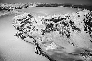
Mount Edziza, sometimes called Edziza Mountain or Edziza Peak, is a stratovolcano in Cassiar Land District of northwestern British Columbia, Canada. It is located on the Big Raven Plateau of the Tahltan Highland which extends along the western side of the Stikine Plateau. The mountain has an elevation of 2,786 metres, making it the highest volcano of the Mount Edziza volcanic complex. However, it had an elevation of at least 3,396 metres before its original summit was likely destroyed by a violent, climactic eruption in the geologic past. Mount Edziza contains several lava domes, cinder cones and lava fields on its flanks, as well as an ice cap that is characterized by several outlet glaciers stretching out to lower altitudes. All sides of the mountain are drained by tributaries of Mess Creek and Kakiddi Creek which are situated within the Stikine River watershed.
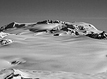
<span class="mw-page-title-main">Level Mountain</span> Volcanic complex in British Columbia, Canada

Level Mountain is a large volcanic complex in the Northern Interior of British Columbia, Canada. It is located 50 kilometres north-northwest of Telegraph Creek and 60 kilometres west of Dease Lake on the Nahlin Plateau. With a maximum elevation of 2,164 metres, it is the second-highest of four large complexes in an extensive north–south trending volcanic region. Much of the mountain is gently-sloping; when measured from its base, Level Mountain is about 1,100 metres tall, slightly taller than its neighbour to the northwest, Heart Peaks. The lower, broader half of Level Mountain consists of a shield-like structure while its upper half has a more steep, jagged profile. Its broad summit is dominated by the Level Mountain Range, a small mountain range with prominent peaks cut by deep valleys. These valleys serve as a radial drainage for several small streams that flow from the mountain. Meszah Peak is the only named peak in the Level Mountain Range.

The Sheep Track Member is a stratigraphic unit of the Big Raven Formation, part of the Mount Edziza volcanic complex in northwestern British Columbia, Canada. It consists of pumice from an explosive eruption that fell over an area about 40 square kilometres. The pumice is of comenditic trachyte composition and reaches a thickness of up to 2 metres along the western edge of Tencho Glacier.

<span class="mw-page-title-main">Mount Edziza volcanic complex</span> Volcanic complex in British Columbia, Canada

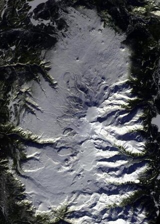
The Mount Edziza volcanic complex is a group of volcanoes and associated lava flows in northwestern British Columbia, Canada. Located on the Tahltan Highland, it is 40 kilometres southeast of Telegraph Creek and 85 kilometres southwest of Dease Lake. The complex encompasses a broad, steep-sided lava plateau that extends over 1,000 square kilometres. Its highest summit is 2,786 metres in elevation, making the MEVC the highest of four large complexes in an extensive north–south trending volcanic region. It is obscured by an ice cap characterized by several outlet glaciers that stretch out to lower altitudes.

<span class="mw-page-title-main">Volcanic history of the Northern Cordilleran Volcanic Province</span>

The volcanic history of the Northern Cordilleran Volcanic Province presents a record of volcanic activity in northwestern British Columbia, central Yukon and the U.S. state of easternmost Alaska. The volcanic activity lies in the northern part of the Western Cordillera of the Pacific Northwest region of North America. Extensional cracking of the North American Plate in this part of North America has existed for millions of years. Continuation of this continental rifting has fed scores of volcanoes throughout the Northern Cordilleran Volcanic Province over at least the past 20 million years and occasionally continued into geologically recent times.

The Nido Formation is a stratigraphic unit of Neogene age in northwestern British Columbia, Canada.

The Pyramid Formation is a stratigraphic unit of Pleistocene age in northwestern British Columbia, Canada.

<span class="mw-page-title-main">Big Raven Formation</span> Geological formation in British Columbia, Canada

The Big Raven Formation is a stratigraphic unit of Holocene age in northwestern British Columbia, Canada. It is the youngest and least voluminous geological formation of the Mount Edziza volcanic complex (MEVC); it overlies at least six older formations of this volcanic complex. The main volcanic rocks of the Big Raven Formation are alkali basalts and hawaiites, although a small volume of trachyte comprises the Sheep Track Member. These rocks were deposited by volcanic eruptions in the last 12,000 years during the latest magmatic cycle of the MEVC. Alkali basalt and hawaiite are in the form of lava flows and small volcanic cones while trachyte of the Sheep Track Member is mainly in the form of volcanic ejecta which covers an area of about 40 square kilometres.

The Klastline Formation is a stratigraphic unit of Pleistocene age in northwestern British Columbia, Canada.

Kakiddi Creek is a tributary of the Klastline River in northwest part of the province of British Columbia, Canada. It flows north about 35 km (22 mi) through two lakes in a broad hummocky lowland to join the Klastline River, which in turn is a tributary of the Stikine River. Kakiddi Creek forms the northeastern boundary of Mount Edziza Provincial Park which lies within the traditional territory of the Tahltan people.

Tennaya Creek is a tributary of Kakiddi Creek, which in turn is a tributary of the Klastline River, part of the Stikine River watershed in northwest part of the province of British Columbia, Canada. It flows generally west for about 16 km (9.9 mi) to join Kakiddi Creek about 19 km (12 mi) south of Kakiddi Creek's confluence with the Klastline River. Tennaya Creek's watershed covers 63.3 km2 (24.4 sq mi) and its mean annual discharge is estimated at 1.50 m3/s (53 cu ft/s). The mouth of Tennaya Creek is located about 48 km (30 mi) southeast of Telegraph Creek, about 30 km (19 mi) southwest of Iskut and about 86 km (53 mi) south-southwest of Dease Lake. Tennaya Creek's watershed's land cover is classified as 31.3% barren, 26.0% conifer forest, 17.9% snow/glacier, 12.6% herbaceous, 9.9% shrubland, and small amounts of other cover.

Tenchen Creek is a tributary of Kakiddi Creek, which in turn is a tributary of the Klastline River, part of the Stikine River watershed in northwest part of the province of British Columbia, Canada. It flows generally flows northeast for about 8 km (5.0 mi) to join Kakiddi Creek about 13 km (8.1 mi) south of Kakiddi Creek's confluence with the Klastline River. Tenchen is a combination of the Tahltan words "ten" and "chen", which mean "ice" and "dirty" respectively.

Tsecha Creek is a tributary of Kakiddi Creek, which in turn is a tributary of the Klastline River, part of the Stikine River watershed in northwest part of the province of British Columbia, Canada. It flows generally west for about 16 km (9.9 mi) to join Kakiddi Creek about 5 km (3.1 mi) south of Kakiddi Creek's confluence with the Klastline River. Tsecha Creek's watershed covers 23.1 km2 (8.9 sq mi) and its mean annual discharge is estimated at 0.423 m3/s (14.9 cu ft/s). The mouth of Tsecha Creek is located about 44 km (27 mi) east-southeast of Telegraph Creek, about 26 km (16 mi) west of Iskut and about 73 km (45 mi) south-southwest of Dease Lake. Tsecha Creek's watershed's land cover is classified as 47.8% barren, 27.5% conifer forest, 13.1% shrubland, 10.3% snow/glacier, and small amounts of other cover.

The Mount Edziza volcanic complex (MEVC) in British Columbia, Canada, has a long history of volcanism that spans more than six million years. It occurred during five cycles of magmatic activity which were characterized by 13 periods of eruptive activity. This volcanism has led to the formation of several types of volcanic landforms, including cinder cones, stratovolcanoes, subglacial volcanoes, shield volcanoes, lava domes and lava fields. The 1,000-square-kilometre (390-square-mile) plateau comprising the MEVC owes its origin to successive eruptions of highly mobile lava flows. Volcanic rocks such as alkali basalt, hawaiite, trachybasalt, benmoreite, tristanite, mugearite, trachyte, comendite and pantellerite were deposited by multiple eruptions of the MEVC; the latter eight are products of varying degrees of magmatic differentiation in underground magma reservoirs.

<span class="mw-page-title-main">Tencho Glacier</span> Glacier in British Columbia, Canada

Tencho Glacier is a mountain glacier in northwestern British Columbia, Canada. It is located inside Mount Edziza Provincial Park on the Tahltan Highland, an upland area of the Stikine Plateau. Tencho Glacier is the source of several small streams that flow from the Mount Edziza volcanic complex.

Tenchen Glacier is located on the eastern flank of Mount Edziza in northwestern British Columbia, Canada. It lies within an immense cirque whose headwall has breached the eastern side of Mount Edziza's summit crater. At the head of Tenchen Glacier are icefalls that drape down shear, 300-metre-high (980-foot) cliffs from the breached eastern crater rim; permanent ice fills the summit crater. Meltwater from Tenchen Glacier feeds Tenchen Creek which eventually merges with Kakiddi Creek.

Tennaya Glacier is one of several glaciers draining the eastern side of the Mount Edziza ice cap in northwestern British Columbia, Canada. It is located southeast of the summit of Mount Edziza and northwest of Ice Peak at the head of Tennaya Creek. Meltwater from Tennaya Glacier feeds Tennaya Creek which eventually flows into Nuttlude Lake, an expansion of Kakiddi Creek.

Idiji Glacier is one of several glaciers draining the eastern side of the Mount Edziza ice cap in northwestern British Columbia, Canada. It is located south of the summit of Mount Edziza in a cirque just southeast of Ice Peak. Idiji Glacier is separated from the much larger Tencho Glacier by a ridge that extends south of Ice Peak above the Idiji cirque headwall.

References

  1. 1 2 3 4 5 6 7 Souther 1992, p. 175.
  2. 1 2 3 4 5 6 7 8 Edwards, Benjamin Ralph (1997). Field, kinetic, and thermodynamic studies of magmatic assimilation in the Northern Cordilleran Volcanic Province, northwestern British Columbia (PhD thesis). University of British Columbia. pp. 3, 10, 11. ISBN   0-612-25005-9.
  3. 1 2 3 4 5 6 7 8 Souther, J. G. (1988). "1623A" (Geologic map). Geology, Mount Edziza Volcanic Complex, British Columbia. 1:50,000. Geological Survey of Canada. doi: 10.4095/133498 .
  4. 1 2 Souther 1992, pp. 98, 134, 152.
  5. 1 2 3 4 "Edziza: General Information". Global Volcanism Program . Smithsonian Institution. Archived from the original on 2021-08-10. Retrieved 2024-03-16.
  6. 1 2 "Edziza Formation". Lexicon of Canadian Geologic Units . Government of Canada. Archived from the original on 2024-03-19. Retrieved 2024-03-16.
  7. "Mount Edziza". BC Geographical Names . Archived from the original on 2018-05-15. Retrieved 2021-09-25.
  8. 1 2 3 4 Souther, J. G.; Armstrong, R. L.; Harakal, J. (1984). "Chronology of the peralkaline, late Cenozoic Mount Edziza Volcanic Complex, northern British Columbia, Canada". Geological Society of America Bulletin . 95 (3). Geological Society of America: 339, 346. doi:10.1130/0016-7606(1984)95<337:COTPLC>2.0.CO;2. ISSN   0016-7606.
  9. "Sheep Track Formation". Lexicon of Canadian Geologic Units . Government of Canada. Archived from the original on 2023-12-15. Retrieved 2023-12-15.
  10. "Kounugu Formation". Lexicon of Canadian Geologic Units . Government of Canada. Archived from the original on 2023-12-15. Retrieved 2023-12-15.
  11. "Big Raven Plateau". BC Geographical Names . Archived from the original on 2021-09-30. Retrieved 2024-04-02.
  12. 1 2 Telegraph Creek, Cassiar Land District, British Columbia (Topographic map) (3 ed.). 1:250,000. A502 (in English and French). Department of Energy, Mines and Resources. 1989. Archived from the original on 2021-05-02. Retrieved 2021-09-25.
  13. Souther 1992, p. 32.
  14. 1 2 Wood, Charles A.; Kienle, Jürgen (1990). Volcanoes of North America: United States and Canada. Cambridge University Press. pp. 124, 125. ISBN   0-521-43811-X.
  15. Holland, Stuart S. (1976). Landforms of British Columbia: A Physiographic Outline (PDF) (Report). Government of British Columbia. pp. 49, 50. ASIN   B0006EB676. OCLC   601782234. Archived from the original (PDF) on 2018-11-14.
  16. "Nuttlude Lake". BC Geographical Names . Retrieved 2024-04-02.
  17. Souther 1992, pp. 93, 98.
  18. Souther 1992, p. 134.
  19. Souther 1992, p. 152.
  20. Souther 1992, p. 171.
  21. Souther 1992, p. 267.
  22. Souther 1992, pp. 177, 182.
  23. 1 2 Souther 1992, pp. 175, 177.
  24. 1 2 3 4 5 Souther 1992, p. 177.
  25. Souther 1992, pp. 21, 177.
  26. Souther 1992, p. 185.
  27. 1 2 3 Souther 1992, p. 184.
  28. 1 2 Souther 1992, p. 179.
  29. Souther 1992, pp. 179, 185.
  30. Souther 1992, p. 181.
  31. Smellie, John L.; Edwards, Benjamin R. (2016). Glaciovolcanism on Earth and Mars: Products, Processes and Palaeoenvironmental Significance. Cambridge University Press. p. 275. ISBN   978-1-107-03739-7.
  32. Souther 1992, p. 182.
  33. Souther 1992, pp. 177, 179.

Sources