The Stikine River is a major river in northern British Columbia (BC), Canada and southeastern Alaska in the United States. It drains a large, remote upland area known as the Stikine Country east of the Coast Mountains. Flowing west and south for 610 kilometres (379 mi), it empties into various straits of the Inside Passage near Wrangell, Alaska. About 90 percent of the river's length and 95 percent of its drainage basin are in Canada. Considered one of the last truly wild large rivers in BC, the Stikine flows through a variety of landscapes including boreal forest, steep canyons and wide glacial valleys.
The Interior Plateau comprises a large region of the Interior of British Columbia, and lies between the Cariboo and Monashee Mountains on the east, and the Hazelton Mountains, Coast Mountains and Cascade Range on the west. The continuation of the plateau into the United States is known there as the Columbia Plateau.

The Boundary Ranges, also known in the singular and as the Alaska Boundary Range, are the largest and most northerly subrange of the Coast Mountains. They begin at the Nass River, near the southern end of the Alaska Panhandle in the Canadian province of British Columbia and run to the Kelsall River, near the Chilkoot Pass, beyond which are the Alsek Ranges of the Saint Elias Mountains, and northwards into the Yukon Territory flanking the west side of the Yukon River drainage as far as Champagne Pass, north of which being the Yukon Ranges. To their east are the Skeena Mountains and Stikine Plateau of the Interior Mountains complex that lies northwest of the Interior Plateau; the immediately adjoining subregion of the Stikine Plateau is the Tahltan Highland. To their northeast is the Tagish Highland, which is a subregion of the Yukon Plateau. Both highlands are considered in some descriptions as included in the Coast Mountains. The Alexander Archipelago lies offshore and is entirely within Alaska.
Great Glacier Provincial Park is a provincial park in the Stikine Country region of British Columbia, Canada. It was established on January 25, 2001 to protect Great Glacier and the surrounding mountainous terrain. The park lies in the traditional territory of the Tahltan First Nation about 120 kilometres (75 mi) south of the Tahltan community of Telegraph Creek.
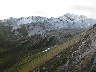
Mount Edziza Provincial Park is a provincial park in Cassiar Land District of northern British Columbia, Canada. It was established on 27 July 1972 to protect the Mount Edziza volcanic complex and the surrounding Tahltan Highland.
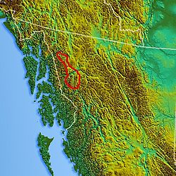
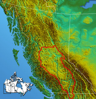
Spatsizi Plateau Wilderness Provincial Park is located in the northern portion of British Columbia, Canada, approximately 698, 659 hectares and encompasses the Spatsizi River and Gladys Lake Ecological Reserve. The park is a designated protected area that is intended for the conservation and research on caribou, grizzly bears, fish, and other wildlife species populations. Before the provincial park's establishment in 1975, the area was a historical hunting ground for local Indigenous communities like the Tahltan First Nations. It is the second largest provincial park in British Columbia.
Chutine Peak is one of the highest mountains in the Boundary Ranges, a group of subranges of the northern Coast Mountains of British Columbia and Alaska. Chutine Peak lies just east of the Stikine Icecap, and to the north and west of the Stikine River, and south of the basin of the Whiting River. It is notable for its huge west face: the drop to Chutine Lake is 2,600 m (8,530 ft) in 3.5 km (2 mi). Due to its remoteness, however, it is rarely visited.
The Okanagan Highland is an elevated hilly plateau area in British Columbia, Canada, and the U.S. state of Washington. Rounded mountains with elevations up to 8,000 ft (2,400 m) above sea level and deep, narrow valleys are characteristic of the region.
The Skeena Mountains, also known as the Skeenas, are a subrange of the Interior Mountains of northern British Columbia, Canada, essentially flanking the upper basin of the Skeena River. They lie just inland from the southern end of the Boundary Ranges of the Coast Mountains, and also of the northern end of the Kitimat Ranges. Their southern limit is described by the Bulkley River and the upper northwestern reaches of Babine and Takla Lakes, and on their northeast by the upper reaches of the Omineca River.

The Tagish Highland is an upland area on the inland side of the northernmost Boundary Ranges of the Coast Mountains, spanning far northwestern British Columbia from Atlin Lake to the area of the pass at Champagne, Yukon between the Alsek and Yukon Rivers. In some classification systems, and in local terminology, the Tagish Highland is considered to be part of the Boundary Ranges, as is the neighbouring Tahltan Highland to its south. As classified by the Canadian Mountain Encyclopedia per S. Holland, the Tagish Highland is part of the system unofficially described as the Interior Mountains.

The Interior Mountains or Northern Interior Mountains are the semi-official names for an expansive collection of mountain ranges that comprises much of the northern half of the Canadian province of British Columbia and a large area of southern Yukon.
The Chechidla Range is a mountain range in northwest British Columbia, Canada, located about 150 km (93 mi) west of Dease Lake and 125–150 km south-southeast of Atlin. It has an area of 3236 km2 and lies roughly in between the Whiting and Sutlahine Rivers on the west and northwest and the Samotua and Sheslay on the east. It is a subrange of the Boundary Ranges which in turn form part of the Coast Mountains of the Pacific Cordillera mountain system. The Whiting River has its source in the range. The range's name is an approximation of a phrase in the Tahltan language meaning "mountains of small rocks".

The Tahltan River is a tributary of the Stikine River in northwest part of the province of British Columbia, Canada. It flows generally east and southeast about 95 km (59 mi) to join the Stikine River at Tahltan, British Columbia. The lower Tahltan River marks the boundary between the Tahltan Highland and the Nahlin Plateau, both of which are part of the larger Stikine Plateau region.

The Stikine Plateau is a plateau in northern British Columbia, Canada. It lies between the Boundary Ranges of the Coast Mountains on the west and southwest and the Cassiar Mountains along its northeast, and between the Skeena Mountains on its south and southeast and the Jennings and Nakina Rivers on the north.
The Nahlin Plateau is a plateau in northwestern British Columbia, Canada, located between the Sheslay River and Tuya River on the west and east and the Nahlin River and the Stikine River to the north and south. It is a subplateau of the Stikine Plateau; adjoining parts of the same larger plateau are the Taku Plateau to the northwest, the Tahltan Highland to the southwest and south, the Kawdy Plateau to the north, and the Spatsizi Plateau to the southeast. The Nahlin Plateau is the location of the Level Mountain Range and Heart Peaks, two small mountain ranges forming parts of large shield volcanoes.
The Klastline Plateau is a plateau in the Stikine Region of the Northern Interior of British Columbia, Canada. A subplateau of the Stikine Plateau, it is located between the Stikine River (N), the upper Iskut River (S), Mess Creek (W) and the Klappan River (E). The Skeena Mountains are to the south, the Tahltan Highland to the west, the Spatsizi Plateau to the east, and the Tanzilla Plateau to the north, on the other side of the Stikine. The Spatsizi and Tanzilla Plateaus, and the Tahltan Highland, are also part of the Stikine Plateau.
The Tanzilla Plateau is a plateau in the Stikine Country of the Northern Interior of British Columbia, Canada. It is a sub-plateau of the Stikine Plateau and is located east of the Tuya River, north of the Stikine River and surrounding Dease Lake; its eastern extremity verges on the Stikine Ranges of the Cassiar Mountains at Dark Mountain and Pyramid Mountain. The Spatsizi Plateau is to the southeast, the Klastline Plateau to the south, the Tahltan Highland to the west and southwest, and the Kawdy Plateau to the west and northwest. All are also sub-plateaus of the Stikine Plateau.
The Taku Plateau is a sub-plateau of the Stikine Plateau in the far northwestern Interior of British Columbia, Canada. It lies to the south of the Teslin Plateau, part of the Yukon Plateau and to the southeast of the Yukon Plateau's other major sub-area within British Columbia, the Tagish Highland. Immediately northeast is the Kawdy Plateau and to the northwest of the Nahlin Plateau. The Inklin River forms the plateau's southwestern boundary with the northwestern extremities of the Tahltan Highland, beyond which are the Boundary Ranges. Very mountainous, its highest summit is Nahlin Mountain.
The Hackett River is a tributary of the Sheslay River in northwest part of the province of British Columbia, Canada. It flows generally northwest about 33 km (21 mi), through two lakes, a wetland, and a gorge, to join the Sheslay River, which in turn is a tributary of the Inklin River, the main southeast fork of the Taku River.

The Bell-Irving River is a tributary of the Nass River in northwestern British Columbia, Canada. It originates in the Sacred Headwaters region, and flows about 165 km (103 mi) south to the Nass River. It course lies between the Oweegee Range of the Skeena Mountains to the east and the Boundary Ranges of the Coast Mountains to the west.