
A tuya is a flat-topped, steep-sided volcano formed when lava erupts through a thick glacier or ice sheet. They are rare worldwide, being confined to regions which were covered by glaciers and had active volcanism during the same period.
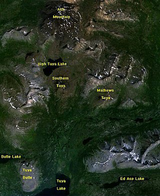
The Tuya volcanic field is a volcanic field of tuyas located in far northern British Columbia, Canada, near the border with the Yukon Territory and focused on the area of the Tuya Range, a subrange of the Stikine Ranges of the Cassiar Mountains, though some vents are in the Kawdy Plateau, the northernmost part of the Stikine Plateau. Several small shield volcanoes, and postglacial lapilli cones and lava flows have been reported in this area. The only nonglacial volcanoes in the field are Gabrielse Cone and the West Tuya lava field.
The Skeena Mountains, also known as the Skeenas, are a subrange of the Interior Mountains of northern British Columbia, Canada, essentially flanking the upper basin of the Skeena River. They lie just inland from the southern end of the Boundary Ranges of the Coast Mountains, and also of the northern end of the Kitimat Ranges. Their southern limit is described by the Bulkley River and the upper northwestern reaches of Babine and Takla Lakes, and on their northeast by the upper reaches of the Omineca River.

Heart Peaks, originally known as the Heart Mountains, is a mountain massif in the Northern Interior of British Columbia, Canada. It is 90 km (56 mi) northwest of the small community of Telegraph Creek and just southwest of Callison Ranch. With a maximum elevation of 2,012 m (6,601 ft), it rises above the surrounding landscape on the Nahlin Plateau, which is part of the western Stikine Plateau. Heart Peaks has been an area of prospecting since the 1980s with the discovery of precious metals.
The Tuya Range is a mountain range in the Stikine Ranges of the Cassiar Mountains in the far north of the Canadian province of British Columbia, near its border with the Yukon Territory and to the southwest of Watson Lake, Yukon, which is the nearest major settlement.

The Interior Mountains or Northern Interior Mountains are the semi-official names for an expansive collection of mountain ranges that comprises much of the northern half of the Canadian province of British Columbia and a large area of southern Yukon.
The Sheslay River is a tributary of the Inklin River in northwest part of the province of British Columbia, Canada. It joins the Nahlin River to form the Inklin River, one of the main tributaries of the Taku River. The lower Sheslay River marks the boundary between the Taku Plateau and the Nahlin Plateau. Its mouth at the Nahlin River marks the junction of the Taku, Nahlin, and Kawdy Plateaus. All three of these are part of the larger Stikine Plateau region.
The Atsutla Range is a granitic mountain range on the Kawdy Plateau in northern British Columbia, Canada. The Atsutla Range lies south of the Yukon border in between Teslin Lake and the Stewart-Cassiar Highway, roughly 120 km (75 mi) north-northeast of Dease Lake.

The Stikine Plateau is a plateau in northern British Columbia, Canada. It lies between the Boundary Ranges of the Coast Mountains on the west and southwest and the Cassiar Mountains along its northeast, and between the Skeena Mountains on its south and southeast and the Jennings and Nakina Rivers on the north.
The McGregor Plateau is a sub-plateau of the Nechako Plateau, the northernmost major subdivision of the Interior Plateau spanning the inland regions of the Pacific Northwest. Located in British Columbia, Canada, to the east of the city of Prince George, British Columbia, the McGregor Plateau lies between the main spine of the Northern Rocky Mountains on the east and the Fraser River on the west, beginning on its southeast at the confluence of the Torpy River with the Fraser and running northwest, parallel to the Fraser and the Rockies, to end in the area of the Arctic and Pacific Lakes to the north of the great bend in the Fraser River just upstream from and to the northeast of Prince George. The McGregor Plateau is very mountainous in character and includes several large rivers, the largest being the McGregor River and Herrick Creek. Included in the McGregor Plateau is the McGregor Range, which lies between the McGregor and Torpy Rivers and the Dezaiko Range, which lies between Herrick and McGregor Rivers.
The Nahlin Plateau is a plateau in northwestern British Columbia, Canada, located between the Sheslay River and Tuya River on the west and east and the Nahlin River and the Stikine River to the north and south. It is a subplateau of the Stikine Plateau; adjoining parts of the same larger plateau are the Taku Plateau to the northwest, the Tahltan Highland to the southwest and south, the Kawdy Plateau to the north, and the Spatsizi Plateau to the southeast. The Nahlin Plateau is the location of the Level Mountain Range and Heart Peaks, two small mountain ranges forming parts of large shield volcanoes.
The Jennings River is a river in far northern British Columbia, Canada. It is approximately 150 kilometres (93 mi) long. The river was named for William T. Jennings (1846-1906), a civil engineer who, in 1897, assessed various road and railroad routes from the Pacific Ocean to the Yukon.
The Tanzilla Plateau is a plateau in the Stikine Country of the Northern Interior of British Columbia, Canada. It is a sub-plateau of the Stikine Plateau and is located east of the Tuya River, north of the Stikine River and surrounding Dease Lake; its eastern extremity verges on the Stikine Ranges of the Cassiar Mountains at Dark Mountain and Pyramid Mountain. The Spatsizi Plateau is to the southeast, the Klastline Plateau to the south, the Tahltan Highland to the west and southwest, and the Kawdy Plateau to the west and northwest. All are also sub-plateaus of the Stikine Plateau.
The Taku Plateau is a sub-plateau of the Stikine Plateau in the far northwestern Interior of British Columbia, Canada. It lies to the south of the Teslin Plateau, part of the Yukon Plateau and to the southeast of the Yukon Plateau's other major sub-area within British Columbia, the Tagish Highland. Immediately northeast is the Kawdy Plateau and to the northwest of the Nahlin Plateau. The Inklin River forms the plateau's southwestern boundary with the northwestern extremities of the Tahltan Highland, beyond which are the Boundary Ranges. Very mountainous, its highest summit is Nahlin Mountain.
Isspah Butte is a tuya in the Atsutla Range of the Kawdy Plateau in northern British Columbia, Canada. It lies on the north side of the Nazcha Creek.
The Tuya River is a major tributary of the Stikine River in northwest part of the province of British Columbia, Canada. From its source at High Tuya Lake in Tuya Mountains Provincial Park just south of Ash Mountain, the highest peak of the Tuya Range, the Tuya River flows south about 200 km (120 mi) to meet the Stikine River in the Grand Canyon of the Stikine. The Tuya River's main tributary is the Little Tuya River. The Tuya River divides the Tanzilla Plateau on the east from the Kawdy Plateau, to the northwest, and the Nahlin Plateau, to the southwest. All three are considered sub-plateaus of the Stikine Plateau. The Tuya River's watershed covers 3,575 km2 (1,380 sq mi), and its mean annual discharge is estimated at 36.9 m3/s (1,300 cu ft/s). The mouth of the Tuya River is located about 24 km (15 mi) northeast of Telegraph Creek, British Columbia, about 67 km (42 mi) southwest of Dease Lake, British Columbia, and about 210 km (130 mi) east of Juneau, Alaska. The Tuya River's watershed's land cover is classified as 35.7% shrubland, 31.4% conifer forest, 14.0% mixed forest, 7.2% herbaceous, and small amounts of other cover.
The Koshin River is a tributary of the Nahlin River in northwest part of the province of British Columbia, Canada. It flows generally north about 58 km (36 mi) to join the Nahlin River, which forms the Inklin River, one of the main tributaries of the Taku River. The Koshin River flows through the Nahlin Plateau. It joins the Nahlin River at the boundary between the Nahlin and Kawdy plateaus. Both plateaus are part of the larger Stikine Plateau region.
Granite Lake is a lake on the Kawdy Plateau of the Northern Interior of British Columbia, Canada. It is located northwest of the junction of the Nahlin and Tuya rivers in Cassiar Land District.
