
The Stikine River is a major river in northern British Columbia (BC), Canada and southeastern Alaska in the United States. It drains a large, remote upland area known as the Stikine Country east of the Coast Mountains. Flowing west and south for 610 kilometres (379 mi), it empties into various straits of the Inside Passage near Wrangell, Alaska. About 90 percent of the river's length and 95 percent of its drainage basin are in Canada. Considered one of the last truly wild large rivers in BC, the Stikine flows through a variety of landscapes including boreal forest, steep canyons and wide glacial valleys.

The Skeena River is the second-longest river entirely within British Columbia, Canada. Since ancient times, the Skeena has been an important transportation artery, particularly for the Tsimshian and the Gitxsan—whose names mean "inside the River of Mist", and "people of the River of Mist," respectively. The river and its basin sustain a wide variety of fish, wildlife, and vegetation, and communities native to the area depend on the health of the river. The Tsimshian migrated to the Lower Skeena River, and the Gitxsan occupy territory of the Upper Skeena.
Spatsizi Plateau Wilderness Provincial Park is located in the northern portion of British Columbia, Canada, approximately 698, 659 hectares and encompasses the Spatsizi River and Gladys Lake Ecological Reserve. The park is a designated protected area that is intended for the conservation and research on caribou, grizzly bears, fish, and other wildlife species populations. Before the provincial park's establishment in 1975, the area was a historical hunting ground for local Indigenous communities like the Tahltan First Nations. It is the second largest provincial park in British Columbia.
The Stikine River Provincial Park is a provincial park in British Columbia. The park covers a total area of approximately 217,000 hectares. The main feature of the Stikine River Provincial Park is a portion of the Stikine River known as "The Grand Canyon". This portion of the river is approximately 80 kilometres long and runs through a canyon that has been created from the river cutting through the rock that now forms the walls of the "canyon".
The Omineca Mountains, also known as "the Ominecas", are a group of remote mountain ranges in the Boreal Cordillera of north-central British Columbia, Canada. They are bounded by the Finlay River on the north, the Rocky Mountain Trench on the east, the Nation Lakes on the south, and the upper reaches of the Omineca River on the west. They form a section of the Continental Divide, that, in this region, separates water drainage between the Arctic and Pacific Oceans. The lower course of the Omineca River flows through the heart of the range. To the south of the Ominecas is the Nechako Plateau, to the west the Skeena Mountains and Hazelton Mountains, to the north the Spatsizi Plateau and the Stikine Ranges, while east across the Rocky Mountain Trench are the Muskwa Ranges.
The Skeena Mountains, also known as the Skeenas, are a subrange of the Interior Mountains of northern British Columbia, Canada, essentially flanking the upper basin of the Skeena River. They lie just inland from the southern end of the Boundary Ranges of the Coast Mountains, and also of the northern end of the Kitimat Ranges. Their southern limit is described by the Bulkley River and the upper northwestern reaches of Babine and Takla Lakes, and on their northeast by the upper reaches of the Omineca River.
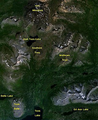
The Tuya Range is a mountain range in the Stikine Ranges of the Cassiar Mountains in the far north of the Canadian province of British Columbia, near its border with the Yukon Territory and to the southwest of Watson Lake, Yukon, which is the nearest major settlement.

The Interior Mountains or Northern Interior Mountains are the semi-official names for an expansive collection of mountain ranges that comprises much of the northern half of the Canadian province of British Columbia and a large area of southern Yukon.

The British Columbia Interior, popularly referred to as the BC Interior or simply the Interior, is a geographic region of the Canadian province of British Columbia. While the exact boundaries are variously defined, the British Columbia Interior is generally defined to include the 14 regional districts that do not have coastline along the Pacific Ocean or Salish Sea, and are not part of the Lower Mainland. Other boundaries may exclude parts of or even entire regional districts, or expand the definition to include the regional districts of Fraser Valley, Squamish–Lillooet, and Kitimat–Stikine.
The Grand Canyon of the Stikine is a 72 km (45 mi) stretch of the Stikine River in northern British Columbia, Canada. It has been compared to the Grand Canyon of the Colorado. The canyon is home to a large population of mountain goats and other wildlife. Officially the canyon is described as unnavigable by any watercraft, however there have been numerous successful descents made by expert whitewater paddlers since the first attempt in 1981. Since it was first attempted, the Grand Canyon of the Stikine has maintained a legendary reputation among whitewater experts as the 'Mt. Everest' of big water expedition whitewater boating against which all other navigable rivers are measured.

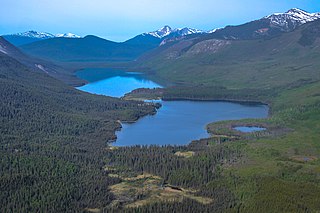
The Stikine Plateau is a plateau in northern British Columbia, Canada. It lies between the Boundary Ranges of the Coast Mountains on the west and southwest and the Cassiar Mountains along its northeast, and between the Skeena Mountains on its south and southeast and the Jennings and Nakina Rivers on the north.

The Iskut River, located in the northwest part of the province of British Columbia is the largest tributary of the Stikine River, entering it about 11 km (6.8 mi) above its entry into Alaska.
The Nahlin Plateau is a plateau in northwestern British Columbia, Canada, located between the Sheslay River and Tuya River on the west and east and the Nahlin River and the Stikine River to the north and south. It is a subplateau of the Stikine Plateau; adjoining parts of the same larger plateau are the Taku Plateau to the northwest, the Tahltan Highland to the southwest and south, the Kawdy Plateau to the north, and the Spatsizi Plateau to the southeast. The Nahlin Plateau is the location of the Level Mountain Range and Heart Peaks, two small mountain ranges forming parts of large shield volcanoes.

The Spatsizi River is a tributary of the Stikine River, rising near Mount Gunanoot in the southeastern Spatsizi Plateau, British Columbia.
Spatsizi Mountain is a mountain in the Spatsizi Plateau, a sub-plateau of the Stikine Plateau in north-central British Columbia, Canada. The name "Spatsizi" derives from the Sekani language and means "red goat", as mountain goats in this region are known to roll on a particular red mountain, resulting in a red colour to their coats.
The Klastline Plateau is a plateau in the Stikine Region of the Northern Interior of British Columbia, Canada. A subplateau of the Stikine Plateau, it is located between the Stikine River (N), the upper Iskut River (S), Mess Creek (W) and the Klappan River (E). The Skeena Mountains are to the south, the Tahltan Highland to the west, the Spatsizi Plateau to the east, and the Tanzilla Plateau to the north, on the other side of the Stikine. The Spatsizi and Tanzilla Plateaus, and the Tahltan Highland, are also part of the Stikine Plateau.
The Tanzilla Plateau is a plateau in the Stikine Country of the Northern Interior of British Columbia, Canada. It is a sub-plateau of the Stikine Plateau and is located east of the Tuya River, north of the Stikine River and surrounding Dease Lake; its eastern extremity verges on the Stikine Ranges of the Cassiar Mountains at Dark Mountain and Pyramid Mountain. The Spatsizi Plateau is to the southeast, the Klastline Plateau to the south, the Tahltan Highland to the west and southwest, and the Kawdy Plateau to the west and northwest. All are also sub-plateaus of the Stikine Plateau.
The Taku Plateau is a sub-plateau of the Stikine Plateau in the far northwestern Interior of British Columbia, Canada. It lies to the south of the Teslin Plateau, part of the Yukon Plateau and to the southeast of the Yukon Plateau's other major sub-area within British Columbia, the Tagish Highland. Immediately northeast is the Kawdy Plateau and to the northwest of the Nahlin Plateau. The Inklin River forms the plateau's southwestern boundary with the northwestern extremities of the Tahltan Highland, beyond which are the Boundary Ranges. Very mountainous, its highest summit is Nahlin Mountain.
The Klappan River is a major tributary of the Stikine River in northwestern British Columbia, Canada. It flows north from an area known as the Sacred Headwaters, which is the source not only of this river but also of the Nass, Skeena, Spatsizi and Stikine Rivers. The headwaters region is the site of a controversial coal-bed methane project.
Gladys Lake Ecological Reserve is an ecological reserve located in the Eaglenest Range of the Spatsizi Plateau in north-central British Columbia, Canada. It was established in 1975 under the Ecological Reserves Act to facilitate scientific research of the region's alpine-subalpine ecosystems while discouraging outdoor recreation use. The reserve protects 44,098 hectares of pristine wilderness and is the largest ecological reserve in British Columbia.

