
The Ozarks, also known as the Ozark Mountains, Ozark Highlands or Ozark Plateau, is a physiographic region in the U.S. states of Missouri, Arkansas, Oklahoma and the extreme southeastern corner of Kansas. The Ozarks cover a significant portion of northern Arkansas and most of the southern half of Missouri, extending from Interstate 40 in central Arkansas to Interstate 70 in central Missouri.

The Edwards Plateau is a geographic region forming the crossroads of Central, South and West Texas, United States. It is named in honor of Haden Edwards. It is bounded by the Balcones Fault to the south and east; the Llano Uplift and the Llano Estacado to the north; and the Pecos River and Chihuahuan Desert to the west. San Angelo, Austin, San Antonio and Del Rio roughly outline the area. The plateau, especially its southeast portion, is also known as the Texas Hill Country.

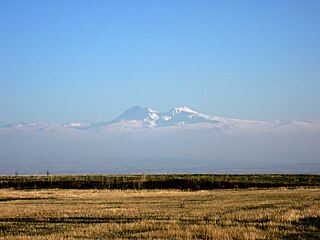
The Iranian Plateau or Persian Plateau is a geological feature spanning parts of Central Asia, South Asia, and West Asia. It makes up part of the Eurasian Plate, and is wedged between the Arabian Plate and the Indian Plate. The plateau is situated between the Zagros Mountains to the west, the Caspian Sea and the Köpet Dag to the north, the Armenian Highlands and the Caucasus Mountains to the northwest, the Strait of Hormuz and the Persian Gulf to the south, and the Indian subcontinent to the east.

The large Deccan Plateau in southern India is located between the Western Ghats and the Eastern Ghats, and is loosely defined as the peninsular region between these ranges that is south of the Narmada River. To the north, it is bounded by the Satpura and Vindhya Ranges.

The North Cascades are a section of the Cascade Range of western North America. They span the border between the Canadian province of British Columbia and the U.S. state of Washington and are officially named in the U.S. and Canada as the Cascade Mountains. The portion in Canada is known to Americans as the Canadian Cascades, a designation that also includes the mountains above the east bank of the Fraser Canyon as far north as the town of Lytton, at the confluence of the Thompson and Fraser Rivers.

The Tibetan Plateau, also known as Qinghai–Tibet Plateau and Qing–Zang Plateau, is a vast elevated plateau located at the intersection of Central, South, and East Asia covering most of the Tibet Autonomous Region, most of Qinghai, western half of Sichuan, Southern Gansu provinces in Western China, southern Xinjiang, Bhutan, the Indian regions of Ladakh and Lahaul and Spiti as well as Gilgit-Baltistan in Pakistan, northwestern Nepal, eastern Tajikistan and southern Kyrgyzstan. It stretches approximately 1,000 kilometres (620 mi) north to south and 2,500 kilometres (1,600 mi) east to west. It is the world's highest and largest plateau above sea level, with an area of 2,500,000 square kilometres (970,000 sq mi). With an average elevation exceeding 4,500 metres (14,800 ft) and being surrounded by imposing mountain ranges that harbor the world's two highest summits, Mount Everest and K2, the Tibetan Plateau is often referred to as "the Roof of the World".

In geology and physical geography, a plateau, also called a high plain or a tableland, is an area of a highland consisting of flat terrain that is raised sharply above the surrounding area on at least one side. Often one or more sides have deep hills or escarpments. Plateaus can be formed by a number of processes, including upwelling of volcanic magma, extrusion of lava, and erosion by water and glaciers. Plateaus are classified according to their surrounding environment as intermontane, piedmont, or continental. A few plateaus may have a small flat top while others have wider ones.

The Cumberland Plateau is the southern part of the Appalachian Plateau in the Appalachian Mountains of the United States. It includes much of eastern Kentucky and Tennessee, and portions of northern Alabama and northwest Georgia. The terms "Allegheny Plateau" and the "Cumberland Plateau" both refer to the dissected plateau lands lying west of the main Appalachian Mountains. The terms stem from historical usage rather than geological difference, so there is no strict dividing line between the two. Two major rivers share the names of the plateaus, with the Allegheny River rising in the Allegheny Plateau and the Cumberland River rising in the Cumberland Plateau in Harlan County, Kentucky.

The Allegheny Plateau is a large dissected plateau area of the Appalachian Mountains in western and central New York, northern and western Pennsylvania, northern and western West Virginia, and eastern Ohio. It is divided into the unglaciated Allegheny Plateau and the glaciated Allegheny Plateau.

The Colorado Plateau, also known as the Colorado Plateau Province, is a physiographic and desert region of the Intermontane Plateaus, roughly centered on the Four Corners region of the southwestern United States. This province covers an area of 336,700 km2 (130,000 mi2) within western Colorado, northwestern New Mexico, southern and eastern Utah, northern Arizona, and a tiny fraction in the extreme southeast of Nevada. About 90% of the area is drained by the Colorado River and its main tributaries: the Green, San Juan, and Little Colorado. Most of the remainder of the plateau is drained by the Rio Grande and its tributaries.

The Columbia Plateau is a geologic and geographic region that lies across parts of the U.S. states of Washington, Oregon, and Idaho. It is a wide flood basalt plateau between the Cascade Range and the Rocky Mountains, cut through by the Columbia River.

The Chota Nagpur Plateau is a plateau in eastern India, which covers much of Jharkhand state as well as adjacent parts of Chhattisgarh, Odisha, West Bengal and Bihar. The Indo-Gangetic plain lies to the north and east of the plateau, and the basin of the Mahanadi river lies to the south. The total area of the Chota Nagpur Plateau is approximately 65,000 square kilometres (25,000 sq mi).

The Thompson River is the largest tributary of the Fraser River, flowing through the south-central portion of British Columbia, Canada. The Thompson River has two main branches, the South Thompson River and the North Thompson River. The river is home to several varieties of Pacific salmon and trout. The area's geological history was heavily influenced by glaciation, and the several large glacial lakes have filled the river valley over the last 12,000 years. Archaeological evidence shows human habitation in the watershed dating back at least 8,300 years. The Thompson was named by Fraser River explorer, Simon Fraser, in honour of his friend, Columbia Basin explorer David Thompson. Recreational use of the river includes whitewater rafting and angling.

The Jos Plateau is a plateau located near the centre of Nigeria. The plateau has given its name to the Plateau State in which it is found and is named for the state's capital, Jos. The plateau is home to people of diverse cultures and languages. The plateau's montane grasslands, savannas, and forests are home to communities of plants and animals distinct from those of the surrounding lowlands and constitute the Jos Plateau forest-savanna mosaic ecoregion.
The Mysore plateau, also known as the South Karnataka plateau, is a plateau that is one of the four geographically unique regions of the Indian state of Karnataka. It has many undulations and is bounded on the west and south by the Western Ghats. Most of the river Kaveri flows through Karnataka in the Mysore Plateau. The average elevation in the region is between 600 and 900 meters. The plateau covers the districts of Bangalore, Bangalore Rural, Chamarajanagar, Hassan, Kodagu, Kolar, Mandya, Mysore and Tumkur.

The Thompson Plateau forms the southern portion of the Interior Plateau of British Columbia, Canada, lying to the west of Okanagan Lake, south of the Thompson River and east of the Fraser River. At its most southern point the plateau is squeezed by the mountainous terrain of the Cascade Range abutting closer to the Okanagan Valley. Its southwestern edge abuts the Canadian Cascades portion of that extensive range, more or less following the line of the Similkameen River, its tributary the Tulameen River, and a series of passes from the area of Tulameen, British Columbia to the confluence of the Thompson River with the Nicoamen River, a few kilometres (miles) east of Lytton, British Columbia, which is in the Fraser Canyon. Its northeastern edge runs approximately from the city of Vernon, British Columbia through the valley of Monte Creek to the junction of the same name just east of the city of Kamloops. Northeast of that line is the Shuswap Highland.
Nicola, also Nkwala or N'kwala, was an important First Nations political figure in the fur trade era of the British Columbia Interior as well as into the colonial period (1858–1871). He was grand chief of the Okanagan people and chief of the Nicola Valley peoples, an alliance of Nlaka'pamux and Okanagans and the surviving Nicola Athapaskans, and also of the Kamloops Band of the Shuswap people.
Nicomen First Nation is a Nlaka'pamux First Nations government located near Lytton, British Columbia. It is a member of the Fraser Canyon Indian Administration as well as of the Scw’exmx Tribal Council, which are two of three tribal councils of the Nlaka'pamux people. The third is the Nlaka'pamux Nation Tribal Council.

Đông Bắc is the region to the north of the Red River Delta in Vietnam, bordering China. It is called Northeast to distinguish it from the Tây Bắc or "Northwest", but it is actually in the north and northeast of Hanoi, wider than Việt Bắc or "Northern Vietnam". The Northeast is one of three sub-regions of Northern Vietnam. Sometimes the Northeast includes the Red River Delta.
Shirak Plain, , is a plain located in the Armenian Plateau, at the northwest of Armenia. It roughly occupies almost the entire area of Shirak Province, the southwestern parts of Lori Province, as well as the northern parts of Aragatsotn Province.
