
The Coast Mountains are a major mountain range in the Pacific Coast Ranges of western North America, extending from southwestern Yukon through the Alaska Panhandle and virtually all of the Coast of British Columbia south to the Fraser River. The mountain range's name derives from its proximity to the sea coast, and it is often referred to as the Coast Range. The range includes volcanic and non-volcanic mountains and the extensive ice fields of the Pacific and Boundary Ranges, and the northern end of the volcanic system known as the Cascade Volcanoes. The Coast Mountains are part of a larger mountain system called the Pacific Coast Ranges or the Pacific Mountain System, which includes the Cascade Range, the Insular Mountains, the Olympic Mountains, the Oregon Coast Range, the California Coast Ranges, the Saint Elias Mountains and the Chugach Mountains. The Coast Mountains are also part of the American Cordillera—a Spanish term for an extensive chain of mountain ranges—that consists of an almost continuous sequence of mountain ranges that form the western backbone of North America, Central America, South America and Antarctica.

The Fraser River is the longest river within British Columbia, Canada, rising at Fraser Pass near Blackrock Mountain in the Rocky Mountains and flowing for 1,375 kilometres (854 mi), into the Strait of Georgia just south of the City of Vancouver. The river's annual discharge at its mouth is 112 cubic kilometres (27 cu mi) or 3,550 cubic metres per second (125,000 cu ft/s), and each year it discharges about 20 million tons of sediment into the ocean.

The Canadian Rockies or Canadian Rocky Mountains, comprising both the Alberta Rockies and the British Columbian Rockies, is the Canadian segment of the North American Rocky Mountains. It is the easternmost part of the Canadian Cordillera, which is the northern segment of the North American Cordillera, the expansive system of interconnected mountain ranges between the Interior Plains and the Pacific Coast that runs northwest–southeast from central Alaska to the Isthmus of Tehuantepec in Mexico.

The Fraser Canyon is a major landform of the Fraser River where it descends rapidly through narrow rock gorges in the Coast Mountains en route from the Interior Plateau of British Columbia to the Fraser Valley. Colloquially, the term "Fraser Canyon" is often used to include the Thompson Canyon from Lytton to Ashcroft, since they form the same highway route which most people are familiar with, although it is actually reckoned to begin above Williams Lake at Soda Creek Canyon near the town of the same name.

The Columbia Mountains are a group of mountain ranges along the Upper Columbia River in British Columbia, Montana, Idaho and Washington. The mountain range covers 135,952 km². The range is bounded by the Rocky Mountain Trench on the east, and the Kootenai River on the south; their western boundary is the edge of the Interior Plateau. Seventy-five percent of the range is located in Canada and the remaining twenty-five percent in the United States; American geographic classifications place the Columbia Mountains as part of the Rocky Mountains complex, but this designation does not apply in Canada. Mount Sir Sandford is the highest mountain in the range, reaching 3,519 metres (11,545 ft).

British Columbia is the westernmost province of Canada, bordered by the Pacific Ocean. With an area of 944,735 km2 (364,764 sq mi) it is Canada's third-largest province. The province is almost four times the size of the United Kingdom and larger than every United States state except Alaska. It is bounded on the northwest by the U.S. state of Alaska, directly north by Yukon and the Northwest Territories, on the east by Alberta, and on the south by the U.S. states of Washington, Idaho, and Montana. Formerly part of the British Empire, the southern border of British Columbia was established by the 1846 Oregon Treaty. The province is dominated by mountain ranges, among them the Canadian Rockies but dominantly the Coast Mountains, Cassiar Mountains, and the Columbia Mountains. Most of the population is concentrated on the Pacific coast, notably in the area of Vancouver, located on the southwestern tip of the mainland, which is known as the Lower Mainland. It is the most mountainous province of Canada.

The Chilcotin Ranges are a subdivision of the Pacific Ranges of the Coast Mountains. They lie on the inland lea of the Pacific Ranges, abutting the Interior Plateau of British Columbia. Their northwestern end is near the head of the Klinaklini River and their southeast end is the Fraser River just north of Lillooet; their northern flank is the edge of the Plateau while their southern is the north bank of the Bridge River. In some reckonings they do not go all the way to the Fraser but end at the Yalakom River, which is the North Fork of the Bridge.
The Interior Plateau comprises a large region of the Interior of British Columbia, and lies between the Cariboo and Monashee Mountains on the east, and the Hazelton Mountains, Coast Mountains and Cascade Range on the west. The continuation of the plateau into the United States is known there as the Columbia Plateau.

The Rocky Mountain Trench, also known as the Valley of a Thousand Peaks or simply the Trench, is a large valley on the western side of the northern part of North America's Rocky Mountains. The Trench is both visually and cartographically a striking physiographic feature extending approximately 1,600 km (1,000 mi) from Flathead Lake, Montana, to the Liard River, just south of the British Columbia–Yukon border near Watson Lake, Yukon. The trench bottom is 3–16 km (1.9–9.9 mi) wide and is 600–900 m (2,000–3,000 ft) above sea level. The general orientation of the Trench is an almost straight 150/330° geographic north vector and has become convenient as a visual guide for aviators heading north or south.

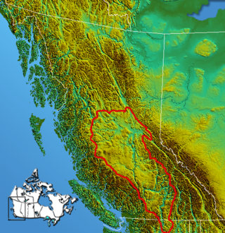
The Cariboo Mountains are the northernmost subrange of the Columbia Mountains, which run down into the Spokane area of the United States and include the Selkirks, Monashees and Purcells. The Cariboo Mountains are entirely within the province of British Columbia, Canada. The range is 7,700 square kilometres (3,000 sq mi) in area and about 245 km in length (southeast–northwest) and about 90 km at its widest (southwest–northeast).

The North American Cordillera, sometimes also called the Western Cordillera of North America, the Western Cordillera, or the Pacific Cordillera, is the North American portion of the American Cordillera, the mountain chain system (cordillera) along the western coast of the Americas. The North American Cordillera covers an extensive area of mountain ranges, intermontane basins, and plateaus in Western and Northwestern Canada, Western United States, and Mexico, including much of the territory west of the Great Plains.
The Omineca Mountains, also known as "the Ominecas", are a group of remote mountain ranges in the Boreal Cordillera of north-central British Columbia, Canada. They are bounded by the Finlay River on the north, the Rocky Mountain Trench on the east, the Nation Lakes on the south, and the upper reaches of the Omineca River on the west. They form a section of the Continental Divide, that, in this region, separates water drainage between the Arctic and Pacific Oceans. The lower course of the Omineca River flows through the heart of the range. To the south of the Ominecas is the Nechako Plateau, to the west the Skeena Mountains and Hazelton Mountains, to the north the Spatsizi Plateau and the Stikine Ranges, while east across the Rocky Mountain Trench are the Muskwa Ranges.
The Nechako Plateau is the northernmost subdivision of the Interior Plateau, one of the main geographic regions of the Canadian province of British Columbia. It spans the basin of the Nechako River and its tributaries the Stuart River and Endako Rivers, and is bounded on the south by the West Road River, south of which is the Chilcotin Plateau and on the north by the Nation River and the valleys of Babine and Takla Lakes, beyond which are the Omineca Mountains (N) and Skeena Mountains (NW). To the west, it abuts the various ranges of the Hazelton Mountains while on its east it is bounded by the pass between Prince George, British Columbia and the Parsnip Arm of Williston Lake, beyond which is the McGregor Plateau, which skirts the Northern Rockies. Some classification systems include the plateau area on the east bank of the Fraser River beyond the city of Prince George; this area neighbours the northernmost reaches of the Quesnel Highland and Cariboo Mountains.

The British Columbia Interior, popularly referred to as the BC Interior or simply the Interior, is a geographic region of the Canadian province of British Columbia. While the exact boundaries are variously defined, the British Columbia Interior is generally defined to include the 14 regional districts that do not have coastline along the Pacific Ocean or Salish Sea, and are not part of the Lower Mainland. Other boundaries may exclude parts of or even entire regional districts, or expand the definition to include the regional districts of Fraser Valley, Squamish–Lillooet, and Kitimat–Stikine.

The Robson Valley is a geographic region of the Canadian province of British Columbia, comprising the section of the Rocky Mountain Trench that lies southeast of the city of Prince George following the Fraser River to the Yellowhead Pass. The name is derived from Mount Robson, which stands near the entrance to the Yellowhead Pass. Communities in the Robson Valley include the settlements of Dome Creek, Crescent Spur, Dunster, and Tête Jaune Cache, with larger population concentrations in the villages of McBride and Valemount. On a map, the Robson Valley is located immediately south of the elbow in the boundary between Alberta and British Columbia. Transportation corridors through the Robson Valley include the Canadian National Railway lines, and Highways 16 and 5.
The McGregor River is a tributary of the Fraser River in the Canadian province of British Columbia.
McGregor existed on the northeast side of the Fraser River 2.2 kilometres (1.4 mi) north-northwest of the Bowron River confluence. Positioned between Sinclair Mills and Upper Fraser, in central British Columbia, the previous community has since dispersed. McGregor, as well as the McGregor River, McGregor Range, Herrick River, Captain Creek and James Creek were named after Captain James Herrick McGregor (1869–1915), a Canadian soldier killed in action during World War I. As a partner in surveyors Gore and McGregor, he had undertaken extensive exploration and survey work in the area.
The McGregor Range is a mountain range in the Central Interior of British Columbia, located between the main spine of the Rocky Mountains and the Fraser River on the northeast and southwest, and between the Torpy River on its southeast and the McGregor River on its northwest. Though adjacent to the Rockies and very mountainous, the McGregor Range is part of the McGregor Plateau, a subdivision of the Fraser Plateau.
The Torpy River is a tributary of the Fraser River, rising in the Northern Rockies and the McGregor Range, a subdivision of the McGregor Plateau, and forming the boundary between the Rockies and the McGregor Plateau.

Longworth Peak, is a 2,094-metre (6,870-feet) mountain in the McGregor Range of the McGregor Plateau in Northern British Columbia. It is the highest peak in the McGregor Range.
