Related Research Articles

Princess Royal Island is the largest island on the North Coast of British Columbia, Canada. It is located amongst the isolated inlets and islands east of Hecate Strait on the British Columbia Coast. At 2,251 square kilometres (869 sq mi), it is the fourth largest island in British Columbia. Princess Royal Island was named in 1788 by Captain Charles Duncan, after his sloop Princess Royal.
Coldwater River Provincial Park is a provincial park in British Columbia, Canada, located at the confluence of the Coldwater River with Cullet Creek, 50 km south of Merritt on BC Highway 5.
Kluskoil Lake Provincial Park is a provincial park in British Columbia, Canada, located on the West Road River downstream from the Euchiniko Lakes.
The Lower Similkameen Indian Band or Lower Smelqmix, is a First Nations band government in the Canadian province of British Columbia. Their office is located in the village of Keremeos in the Similkameen region. They are a member of the Okanagan Nation Alliance.
The Kluskus First Nation is the band government of the Lhoosk’uz, a Dakelh people whose main reserve located on the Chilcotin Plateau 130 km west of the city of Quesnel, British Columbia, Canada. The First Nation is a member of the Carrier-Chilcotin Tribal Council, which includes both Tsilhqot'in and Carrier (Dakelh) communities.

The Robson Valley is a geographic region of the Canadian province of British Columbia, comprising the section of the Rocky Mountain Trench that lies southeast of the city of Prince George following the Fraser River to the Yellowhead Pass. The name is derived from Mount Robson, which stands near the entrance to the Yellowhead Pass. Communities in the Robson Valley include the settlements of Dome Creek, Crescent Spur, Dunster, and Tête Jaune Cache, with larger population concentrations in the villages of McBride and Valemount. On a map, the Robson Valley is located immediately south of the elbow in the boundary between Alberta and British Columbia. Transportation corridors through the Robson Valley include the Canadian National Railway lines, and Highways 16 and 5.

Chiange is a town and commune in the municipality of Gambos, province of Huíla, Angola.
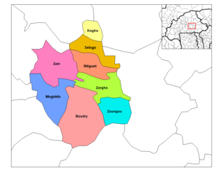
Boudry is a department or commune of Ganzourgou Province in central-eastern Burkina Faso. Its capital is the town of Boudry. According to the 2019 census the department has a total population of 123,070.
Bridge Creek is a creek in the South Cariboo region of the Interior of British Columbia, Canada. Its meandering course across the Cariboo Plateau is approximately 85 kilometres in length, beginning at Bridge Lake and running roughly westwards to the town of 100 Mile House and from there turning and running northeast to Canim Lake. Below Canim Lake the Canim River connects to Mahood Lake and the short Mahood River to the Clearwater River, which meets the North Thompson at the town of Clearwater.
The Blueberry River is a river in the Peace River Block of northeastern British Columbia, Canada. It is a tributary of the Beatton River, which is a tributary of the Peace River.
The Nazko First Nation is a First Nations government of the Dakelh people in the north-central Interior of British Columbia. Its reserves are located around the community of Nazko, British Columbia, which is 120 km west of Quesnel and southwest of Prince George.

The McGregor Plateau is a sub-plateau of the Nechako Plateau, the northernmost major subdivision of the Interior Plateau spanning the inland regions of the Pacific Northwest. Located in British Columbia, Canada, to the east of the city of Prince George, British Columbia, the McGregor Plateau lies between the main spine of the Northern Rocky Mountains on the east and the Fraser River on the west, beginning on its southeast at the confluence of the Torpy River with the Fraser and running northwest, parallel to the Fraser and the Rockies, to end in the area of the Arctic and Pacific Lakes to the north of the great bend in the Fraser River just upstream from and to the northeast of Prince George. The McGregor Plateau is very mountainous in character and includes several large rivers, the largest being the McGregor River and Herrick Creek. Included in the McGregor Plateau is the McGregor Range, which lies between the McGregor and Torpy Rivers.
The McGregor Range is a mountain range in the Central Interior of British Columbia, located between the main spine of the Rocky Mountains and the Fraser River on the northeast and southwest, and between the Torpy River on its southeast and the McGregor River on its northwest. Though adjacent to the Rockies and very mountainous, the McGregor Range is part of the McGregor Plateau, a subdivision of the Fraser Plateau.
The Swift River is a river that begins in Yukon Territory and flows southwest into British Columbia to its mouth at the east side of Teslin Lake on the Teslin River system. The river drains the uppermost portion of the Cassiar Mountains and in its lower reaches traverses the Nisutlin Plateau, which lies along the east side of Teslin Lake north of the mouth of the Jennings River, which is to the south of the Swift.
Batchelor Hill 733 m (2405 ft) prominence: 128 m, is a hill overlooking the city of Kamloops, British Columbia, Canada, immediately northwest of the city and north of the neighbourhood of Brocklehurst. It is the namesake of the Batchelor Hills aka Batchelor Heights neighbourhood and also of the small Batchelor Range, which runs north from it on the side of the Kamloops Plateau but does not include it.
McGregor Pass, 1,555 metres (5,102 ft), is a mountain pass located on the Continental Divide in the Canadian Rockies and near the head of the McGregor River, to the north of Wishaw Mountain and to the west of Kakwa Pass, which is in the same vicinity. McGregor Pass forms the division between the Hart Ranges of the Rockies, which begin at Mount Sir Alexander just to the northwest and extend to the Peace Reach of Lake Williston, and the Continental Ranges, the largest and most well-known segment of the Canadian Rockies, which extend to Marias Pass, at the head of the North Fork Flathead River in Montana, United States.
Kakwa Pass, 1,570 metres (5,151 ft), is a mountain pass in the Canadian Rockies. It is located in the province of British Columbia on the Continental Divide. It is located just east of McGregor Pass and to the north of the town of McBride.

The Takoradi Harbour is in the Western region of Ghana. It is located in the industrial district of Sekondi-Takoradi and is the oldest harbour in Ghana. The Takoradi harbour and the Tema Harbour are the only harbours in Ghana.
Vidette is an unincorporated locality in the Deadman River Valley in the Thompson-Bonaparte Country region of the Central Interior of British Columbia, Canada. It is just north of Vidette Lake, which has become famous for being declared the "Centre of the Universe" by Tibetan Buddhist monks. The locality's name derives from the French spoken by fur trades, when a roadhouse here was on the Hudson's Bay Brigade Trail connecting Fort Kamloops to Fort Alexandria via the Bonaparte Plateau, and which became part of the Gold Rush Trail from the United States to the Cariboo Gold Rush.
Parowan Creek, is a stream in the Parowan Valley of Iron County, Utah. It flows north through Parowan, Utah to its mouth at an elevation of 5,686 feet / 1,733 meters at the Little Salt Lake in Parowan Valley. Its source is located at an elevation of 9,980 feet at 37°40′57″N112°51′16″W in Brian Head, Utah in the Markagunt Plateau.
References
Coordinates: 53°44′00″N120°54′00″W / 53.73333°N 120.90000°W