
The Chilcotin Group, also called the Chilcotin Plateau Basalts, is a large area of basaltic lava that forms a volcanic plateau running parallel with the Garibaldi Volcanic Belt in south-central British Columbia, Canada.
The Chilcotin region of British Columbia is usually known simply as "the Chilcotin", and also in speech commonly as "the Chilcotin Country" or simply Chilcotin. It is a plateau and mountain region in British Columbia on the inland lee of the Coast Mountains on the west side of the Fraser River. Chilcotin is also the name of the river draining that region. In the language of the Tsilhqot'in people, their name and the name of the river means "those of the red ochre river". The proper name of the Chilcotin Country, or Tsilhqotʼin territory, in their language is Tŝilhqotʼin Nen.

The Chilcotin River /tʃɪlˈkoʊtɪn/ located in Southern British Columbia, Canada is a 241 km (150 mi) long tributary of the Fraser River. The name Chilcotin comes from Tŝilhqot’in, meaning "ochre river people," where ochre refers to the mineral used by Tŝilhqot’in Nation and other Indigenous communities as a base for paint or dye. The Chilcotin River, Chilko River and Lake, and Taseko River and Lake make up the Chilcotin River watershed. This 19,200 km2 (7,400 sq mi) watershed drains the Chilcotin Plateau which reaches north to south from the Nechako Plateau to Bridge River county and east to west from Fraser River to the Coast Mountains. It is also one of twelve watersheds that make up the Fraser River Basin. Made up of seven major tributaries, Chilcotin River starts northeast of Itcha Mountain, flowing southeast until it joins the Fraser River south of Williams Lake, 22 km (14 mi) upstream from Gang Ranch.

The Clear Range is a small mountain range located in the angle of the Fraser and Thompson Rivers in south-central British Columbia, Canada. It has a small subdivision just northeast of that confluence named the Scarped Range. The Clear Range totals 16,270 km2 (6,280 sq mi) and is 75 km (47 mi) north to south and 35 km (22 mi) east to west. The Clear Range and its northward neighbour the Marble Range are both subranges of the Pavilion Range.
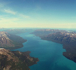
Tŝilhqox Biny, known as Chilko Lake, is a 180 km2 lake in west-central British Columbia, at the head of the Chilko River on the Chilcotin Plateau. The lake is about 65 km long, with a southwest arm 10 km long. It is one of the largest lakes by volume in the province because of its great depth, and the largest above 1,000 m in elevation. It and Harrison Lake are the largest lakes in the southern Coast Mountains.

British Columbia is the westernmost province of Canada, bordered by the Pacific Ocean. With an area of 944,735 km2 (364,764 sq mi) it is Canada's third-largest province. The province is almost four times the size of the United Kingdom and larger than every United States state except Alaska. It is bounded on the northwest by the U.S. state of Alaska, directly north by Yukon and the Northwest Territories, on the east by Alberta, and on the south by the U.S. states of Washington, Idaho, and Montana. Formerly part of the British Empire, the southern border of British Columbia was established by the 1846 Oregon Treaty. The province is dominated by mountain ranges, among them the Canadian Rockies but dominantly the Coast Mountains, Cassiar Mountains, and the Columbia Mountains. Most of the population is concentrated on the Pacific coast, notably in the area of Vancouver, located on the southwestern tip of the mainland, which is known as the Lower Mainland. It is the most mountainous province of Canada.

The Pacific Ranges are the southernmost subdivision of the Coast Mountains portion of the Pacific Cordillera. Located entirely within British Columbia, Canada, they run northwest from the lower stretches of the Fraser River to Bella Coola and Burke Channel, north of which are the Kitimat Ranges. The Coast Mountains lie between the Interior Plateau and the Coast of British Columbia.

The Chilcotin Ranges are a subdivision of the Pacific Ranges of the Coast Mountains. They lie on the inland lea of the Pacific Ranges, abutting the Interior Plateau of British Columbia. Their northwestern end is near the head of the Klinaklini River and their southeast end is the Fraser River just north of Lillooet; their northern flank is the edge of the Plateau while their southern is the north bank of the Bridge River. In some reckonings they do not go all the way to the Fraser but end at the Yalakom River, which is the North Fork of the Bridge.
The Interior Plateau comprises a large region of the Interior of British Columbia, and lies between the Cariboo and Monashee Mountains on the east, and the Hazelton Mountains, Coast Mountains and Cascade Range on the west. The continuation of the plateau into the United States is known there as the Columbia Plateau.

The Homathko River is one of the major rivers of the southern Coast Mountains of the Canadian province of British Columbia. It is one of the few rivers that penetrates the range from the interior Chilcotin Country to the coastal inlets of the Pacific Ocean. The Homathko River reaches the sea at the head of Bute Inlet, just west of the mouth of the Southgate River.

The Camelsfoot Range is a sub-range of the Chilcotin Ranges subdivision of the Pacific Ranges of the Coast Mountains in British Columbia. The Fraser River forms its eastern boundary. The range is approximately 90 km at its maximum length and less than 30 km wide at its widest.

The Cariboo Plateau is a volcanic plateau in south-central British Columbia, Canada. It is part of the Fraser Plateau that itself is a northward extension of the North American Plateau. The southern limit of the plateau is the Bonaparte River although some definitions include the Bonaparte Plateau between that river and the Thompson, but it properly is a subdivision of the Thompson Plateau. The portion of the Fraser Plateau west of the Fraser River is properly known as the Chilcotin Plateau but is often mistakenly considered to be part of the Cariboo Plateau, which is east of the Fraser.
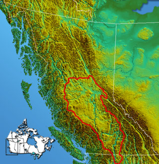
The Chilcotin Plateau is part of the Fraser Plateau, a major subdivision of the Interior Plateau of British Columbia. The Chilcotin Plateau is physically near-identical with the region of the same name, i.e. "the Chilcotin", which lies between the Fraser River and the southern Coast Mountains and is defined by the basin of the Chilcotin River and so includes montane areas beyond the plateau. East of the Chilcotin Plateau, across the Fraser River, is the Cariboo Plateau, while to the north beyond the West Road (Blackwater) River is the Nechako Plateau. West and south of the Chilcotin Plateau are various subdivisions of the Coast Mountains, including the Chilcotin Ranges which lie along the plateau's southwest.

The Thompson Plateau forms the southern portion of the Interior Plateau of British Columbia, Canada, lying to the west of Okanagan Lake, south of the Thompson River and east of the Fraser River. At its most southern point the plateau is squeezed by the mountainous terrain of the Cascade Range abutting closer to the Okanagan Valley. Its southwestern edge abuts the Canadian Cascades portion of that extensive range, more or less following the line of the Similkameen River, its tributary the Tulameen River, and a series of passes from the area of Tulameen, British Columbia to the confluence of the Thompson River with the Nicoamen River, a few kilometres (miles) east of Lytton, British Columbia, which is in the Fraser Canyon. Its northeastern edge runs approximately from the city of Vernon, British Columbia through the valley of Monte Creek to the junction of the same name just east of the city of Kamloops. Northeast of that line is the Shuswap Highland.
The Nechako Plateau is the northernmost subdivision of the Interior Plateau, one of the main geographic regions of the Canadian province of British Columbia. It spans the basin of the Nechako River and its tributaries the Stuart River and Endako Rivers, and is bounded on the south by the West Road River, south of which is the Chilcotin Plateau and on the north by the Nation River and the valleys of Babine and Takla Lakes, beyond which are the Omineca Mountains (N) and Skeena Mountains (NW). To the west, it abuts the various ranges of the Hazelton Mountains while on its east it is bounded by the pass between Prince George, British Columbia and the Parsnip Arm of Williston Lake, beyond which is the McGregor Plateau, which skirts the Northern Rockies. Some classification systems include the plateau area on the east bank of the Fraser River beyond the city of Prince George; this area neighbours the northernmost reaches of the Quesnel Highland and Cariboo Mountains.
Black Dome Mountain is the northernmost summit of the Camelsfoot Range, which lies along the west side of the Fraser River, north of Lillooet, British Columbia, Canada. It is an ancient butte-like volcano located in the formation known as the Chilcotin Group, which lie between the Pacific Ranges of the Coast Mountains and the mid-Fraser River in British Columbia, Canada.

The British Columbia Interior, popularly referred to as the BC Interior or simply the Interior, is a geographic region of the Canadian province of British Columbia. While the exact boundaries are variously defined, the British Columbia Interior is generally defined to include the 14 regional districts that do not have coastline along the Pacific Ocean or Salish Sea, and are not part of the Lower Mainland. Other boundaries may exclude parts of or even entire regional districts, or expand the definition to include the regional districts of Fraser Valley, Squamish–Lillooet, and Kitimat–Stikine.

The Ilgachuz Range is a name given to an extinct shield volcano in British Columbia, Canada. It is not a mountain range in the normal sense, because it was formed as a single volcano that has been eroded for the past 5 million years. It lies on the Chilcotin Plateau, located some 350 kilometres (220 mi) north-northwest of Vancouver and 30 km north of Anahim Lake. The highest peak of the range is Far Mountain. The range supports a unique grassland ecosystem. This type of grassland has not been seen anywhere else in central and southern British Columbia. The climate is cool and dry; typical of higher elevations of the Interior Plateau.
Stockton Hill is a volcanic plug located in the formation known as the Chilcotin Group, which lie between the Pacific Ranges of the Coast Mountains and the mid-Fraser River in British Columbia, Canada.
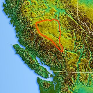
The Dil-Dil Plateau is a small lava plateau on the west side of the upper valley of Big Creek in the southern Chilcotin District of the Central Interior of British Columbia. The plateau is a shelf-like extension of the subrange of the Chilcotin Ranges containing Taseko Mountain and Mount Vic to the west, and is roughly rectangular in shape, and of c.25–30 km2 in area and forming a transition between the range and the Chilcotin Plateau at 2000m-2300m.

