Related Research Articles

The Coast Mountains are a major mountain range in the Pacific Coast Ranges of western North America, extending from southwestern Yukon through the Alaska Panhandle and virtually all of the Coast of British Columbia south to the Fraser River. The mountain range's name derives from its proximity to the sea coast, and it is often referred to as the Coast Range. The range includes volcanic and non-volcanic mountains and the extensive ice fields of the Pacific and Boundary Ranges, and the northern end of the volcanic system known as the Cascade Volcanoes. The Coast Mountains are part of a larger mountain system called the Pacific Coast Ranges or the Pacific Mountain System, which includes the Cascade Range, the Insular Mountains, the Olympic Mountains, the Oregon Coast Range, the California Coast Ranges, the Saint Elias Mountains and the Chugach Mountains. The Coast Mountains are also part of the American Cordillera—a Spanish term for an extensive chain of mountain ranges—that consists of an almost continuous sequence of mountain ranges that form the western backbone of North America, Central America, South America and Antarctica.

The Stikine River is a major river in northern British Columbia (BC), Canada and southeastern Alaska in the United States. It drains a large, remote upland area known as the Stikine Country east of the Coast Mountains. Flowing west and south for 610 kilometres (379 mi), it empties into various straits of the Inside Passage near Wrangell, Alaska. About 90 percent of the river's length and 95 percent of its drainage basin are in Canada. Considered one of the last truly wild large rivers in BC, the Stikine flows through a variety of landscapes including boreal forest, steep canyons and wide glacial valleys.

Alsek River is a wilderness river flowing from Yukon into Northern British Columbia and into Alaska. It enters the Gulf of Alaska at Dry Bay.

The Boundary Ranges, also known in the singular and as the Alaska Boundary Range, are the largest and most northerly subrange of the Coast Mountains. They begin at the Nass River, near the southern end of the Alaska Panhandle in the Canadian province of British Columbia and run to the Kelsall River, near the Chilkoot Pass, beyond which are the Alsek Ranges of the Saint Elias Mountains, and northwards into the Yukon Territory flanking the west side of the Yukon River drainage as far as Champagne Pass, north of which being the Yukon Ranges. To their east are the Skeena Mountains and Stikine Plateau of the Interior Mountains complex that lies northwest of the Interior Plateau; the immediately adjoining subregion of the Stikine Plateau is the Tahltan Highland. To their northeast is the Tagish Highland, which is a subregion of the Yukon Plateau. Both highlands are considered in some descriptions as included in the Coast Mountains. The Alexander Archipelago lies offshore and is entirely within Alaska.
The Ethel Wilson Fiction Prize, established in 1985 as one of the BC and Yukon Book Prizes, is awarded annually to the best work of fiction by a resident of British Columbia, Canada.
The Dorothy Livesay Poetry Prize, established in 1986, is awarded annually to the best collection of poetry by a resident of British Columbia, Canada.
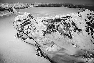
Mount Edziza, known to the local Tahltan people as Tenh Dẕetle, is a volcanic mountain in Cassiar Land District of northwestern British Columbia, Canada. It is located on the Big Raven Plateau of the Tahltan Highland which extends along the western side of the Stikine Plateau. Mount Edziza has an elevation of 2,786 metres, making it the highest point of the Mount Edziza volcanic complex. However, it had an elevation of at least 3,396 metres before its formerly cone-shaped summit was likely destroyed by a violent eruption in the geologic past; its current flat summit contains an ice-filled, 2-kilometre-in diameter (1.2-mile) crater. The mountain contains several lava domes, cinder cones and lava fields on its flanks, as well as an ice cap containing several outlet glaciers which stretch out to lower altitudes. All sides of Mount Edziza are drained by tributaries of Mess Creek and Kakiddi Creek which are situated within the Stikine River watershed.

The Spectrum Range, formerly gazetted as the Spectrum Mountains and the Rainbow Mountains, is a small mountain range in Cassiar Land District of northwestern British Columbia, Canada. Located at the southern end of the Tahltan Highland, it borders the Skeena Mountains in the east and the Boundary Ranges of the Coast Mountains in the west. The Spectrum Range is surrounded by the Arctic Lake Plateau in the southwest and the Kitsu Plateau in the northwest, both of which contain volcanic features such as cinder cones. It lies at the southern end of the Mount Edziza volcanic complex which includes the two neighbouring plateaus as well as Mount Edziza and the Big Raven Plateau to the north. The mountain range is drained on all sides by streams within the Stikine River watershed and, unlike Mount Edziza to the north, contains relatively small separate glaciers. Mount Edziza Provincial Park is the main protected area surrounding the Spectrum Range.

Level Mountain is a large volcanic complex in the Northern Interior of British Columbia, Canada. It is located 50 kilometres north-northwest of Telegraph Creek and 60 kilometres west of Dease Lake on the Nahlin Plateau. With a maximum elevation of 2,164 metres, it is the second-highest of four large complexes in an extensive north–south trending volcanic region. Much of the mountain is gently sloping; when measured from its base, Level Mountain is about 1,100 metres tall, slightly taller than its neighbour to the northwest, Heart Peaks. The lower, broader half of Level Mountain consists of a shield-like structure while its upper half has a more steep, jagged profile. Its broad summit is dominated by the Level Mountain Range, a small mountain range with prominent peaks cut by deep valleys. These valleys serve as a radial drainage for several small streams that flow from the mountain. Meszah Peak is the only named peak in the Level Mountain Range.

Nahta Cone is a small cinder cone in Cassiar Land District of northwestern British Columbia, Canada. It has an elevation of 1,670 metres and lies near the northern edge of the Arctic Lake Plateau, a glacially scored plateau of the Tahltan Highland which in turn extends along the western side of the Stikine Plateau. The cone is about 70 kilometres south-southeast of the community of Telegraph Creek and lies in the southwestern corner of Mount Edziza Provincial Park, one of the largest provincial parks in British Columbia.

The Kitsu Plateau is a small intermontane plateau in Cassiar Land District of northwestern British Columbia, Canada. It lies on the Tahltan Highland and is surrounded by several valleys, including those of Mess Creek, Nagha Creek and Raspberry Creek. The plateau is drained by many small streams that flow into these neighbouring valleys and, unlike the valleys, it is relatively barren of vegetation. Surrounding the Kitsu Plateau is Mount Edziza Provincial Park which is one of the largest provincial parks in British Columbia. Access to this remote plateau is mainly by aircraft since motorized vehicles are prohibited from entering Mount Edziza Provincial Park.

Tennena Cone, alternatively Icebridge Cone, is a small volcanic cone in Cassiar Land District of northwestern British Columbia, Canada. It has an elevation of 2,390 metres and lies on the western flank of Ice Peak, the prominent south peak of Mount Edziza. The cone is almost completely surrounded by glacial ice of Mount Edziza's ice cap which covers an area of around 70 square kilometres. Tennena Cone is 200 metres high, 1,200 metres long and up to 600 metres wide, its symmetrical structure resembling a black pyramid. The cone and the surrounding area are in Mount Edziza Provincial Park which also includes the Spectrum Range to the south.

The Mount Edziza volcanic complex is a group of volcanoes and associated lava flows in northwestern British Columbia, Canada. Located on the Tahltan Highland, it is 40 kilometres southeast of Telegraph Creek and 85 kilometres southwest of Dease Lake. The complex encompasses a broad, steep-sided lava plateau that extends over 1,000 square kilometres. Its highest summit is 2,786 metres in elevation, making the MEVC the highest of four large complexes in an extensive north–south trending volcanic region. It is obscured by an ice cap characterized by several outlet glaciers that stretch out to lower altitudes.
Mount Vic is a mountain in the Chilcotin Ranges of the Central Interior of British Columbia, Canada, located east of the southernmost of the Taseko Lakes and southeast of Taseko Mountain. Adjoining its lower slopes to the northeast is the Dil-Dil Plateau, a lava plateau rising above the main Chilcotin Plateau, which extends north and northeast in general from this area, which is to the west of the headwaters of Big Creek. Mount Vic is one of the highest summits of the southern Chilcotin Ranges, which are a subrange of the Pacific Ranges subdivision of the Coast Mountains.

The Yukon Plateau is a plateau located in the Yukon Territory, comprising much of the central and southern Yukon Territory and the far northern part of British Columbia, Canada between Tagish Lake (W) and the Cassiar Mountains (E) and north of the Nakina River.
The Taku Plateau is a sub-plateau of the Stikine Plateau in the far northwestern Interior of British Columbia, Canada. It lies to the south of the Teslin Plateau, part of the Yukon Plateau and to the southeast of the Yukon Plateau's other major sub-area within British Columbia, the Tagish Highland. Immediately northeast is the Kawdy Plateau and to the northwest of the Nahlin Plateau. The Inklin River forms the plateau's southwestern boundary with the northwestern extremities of the Tahltan Highland, beyond which are the Boundary Ranges. Very mountainous, its highest summit is Nahlin Mountain.
The Mess Creek Escarpment is a long, discontinuous cliff along Mess Creek in Cassiar Land District of northwestern British Columbia, Canada. It forms the east-central side of Mess Creek valley and consists of two segments separated about 5 kilometres by Walkout Creek valley. The northern segment extends about 8 kilometres southeast along the southwestern side of the Big Raven Plateau while the southern segment extends generally south along the northwestern, western and southwestern edges of the Kitsu Plateau for about 10 kilometres. With an elevation of more than 1,700 metres, the Mess Creek Escarpment rises more than 910 metres above the floor of Mess Creek valley. The escarpment lies within the boundaries of Mount Edziza Provincial Park.
Raspberry Creek is a tributary of Mess Creek, which in turn is a tributary of the Stikine River in northwest part of the province of British Columbia, Canada. It flows generally northwest for at least 12 km (7.5 mi) to join Mess Creek about 6 km (3.7 mi) north of Mess Creek's confluence with Kitsu Creek. Raspberry Creek's watershed covers 129 km2 (50 sq mi) and its mean annual discharge is estimated at 3.472 m3/s (122.6 cu ft/s). The mouth of Raspberry Creek is located about 40 km (25 mi) southeast of Telegraph Creek, about 61 km (38 mi) southwest of Iskut and about 110 km (68 mi) southwest of Dease Lake. Raspberry Creek's watershed's land cover is classified as 35.1% barren, 24.9% shrubland, 20.7% conifer forest, 16.8% herbaceous, and small amounts of other cover.
Mess Creek, formerly known as Mestua, is a tributary of the Stikine River in northwestern British Columbia, Canada. It flows north and northwest for about 110 km (68 mi), through a lake and a gorge to join the Stikine River, which in turn flows southwest across the Canada–United States border into Alaska where it empties into various straits of the Inside Passage. The northern half of Mess Creek forms a western boundary of Mount Edziza Provincial Park which lies within the traditional territory of the Tahltan people.
Taweh Creek is a tributary of Mess Creek, which in turn is a tributary of the Stikine River in northwest part of the province of British Columbia, Canada. It flows generally northwest for about 25 km (16 mi) to join Mess Creek about 15 km (9.3 mi) northwest of Mess Creek's confluence with Raspberry Creek. Taweh Creek's watershed covers 159 km2 (61 sq mi) and its mean annual discharge is estimated at 4.32 m3/s (153 cu ft/s). The mouth of Taweh Creek is located about 25 km (16 mi) southeast of Telegraph Creek, about 60 km (37 mi) west-southwest of Iskut and about 100 km (62 mi) southwest of Dease Lake. Taweh Creek's watershed's land cover is classified as 41.3% barren, 21.1% shrubland, 20.7% conifer forest, 8.4% herbaceous, 8.1% snow/glacier, and small amounts of other cover.
References
- 1 2 3 4 5 "Adams Plateau". BC Geographical Names . Retrieved 2024-09-26.
- 1 2 3 4 5 "Alberta Plateau". BC Geographical Names . Retrieved 2024-09-26.
- 1 2 3 4 5 "Arctic Lake Plateau". BC Geographical Names . Retrieved 2024-09-26.
- 1 2 3 4 5 "Big Raven Plateau". BC Geographical Names . Retrieved 2024-09-26.
- 1 2 3 4 5 "Bonaparte Plateau". BC Geographical Names . Retrieved 2024-09-26.
- 1 2 3 4 5 "Cariboo Plateau". BC Geographical Names . Retrieved 2024-09-26.
- 1 2 3 4 5 "Clayoquot Plateau Park". BC Geographical Names . Retrieved 2024-09-26.
- 1 2 3 4 5 "Coutlee Plateau". BC Geographical Names . Retrieved 2024-09-26.
- 1 2 3 4 5 "Dease Plateau". BC Geographical Names . Retrieved 2024-09-26.
- 1 2 3 4 5 "Dil-Dil Plateau". BC Geographical Names . Retrieved 2024-09-26.
- 1 2 3 4 5 "Douglas Plateau". BC Geographical Names . Retrieved 2024-09-26.
- 1 2 3 4 5 "Etsho Plateau". BC Geographical Names . Retrieved 2024-09-26.
- 1 2 3 4 5 "Forbidden Plateau". BC Geographical Names . Retrieved 2024-09-26.
- 1 2 3 4 5 "Fraser Plateau". BC Geographical Names . Retrieved 2024-09-26.
- 1 2 3 4 5 "Green Timber Plateau". BC Geographical Names . Retrieved 2024-09-26.
- 1 2 3 4 5 "Interior Plateau". BC Geographical Names . Retrieved 2024-09-26.
- 1 2 3 4 5 "Kawdy Plateau". BC Geographical Names . Retrieved 2024-09-26.
- 1 2 3 4 5 "Kimberley Plateau". BC Geographical Names . Retrieved 2024-09-26.
- 1 2 3 4 5 "Kitsu Plateau". BC Geographical Names . Retrieved 2024-09-26.
- 1 2 3 4 5 "Klastline Plateau". BC Geographical Names . Retrieved 2024-09-26.
- 1 2 3 4 5 "Kukwaus Plateau". BC Geographical Names . Retrieved 2024-09-26.
- 1 2 3 4 5 "Level Mountain Range". BC Geographical Names . Retrieved 2024-10-01.
- ↑ Wood, Charles A.; Kienle, Jürgen (1990). Volcanoes of North America: United States and Canada. Cambridge University Press. p. 121. ISBN 0-521-43811-X.
- 1 2 3 4 5 "Liard Plateau". BC Geographical Names . Retrieved 2024-10-01.
- 1 2 3 4 5 "McGregor Plateau". BC Geographical Names . Retrieved 2024-10-01.
- 1 2 3 4 5 "Nahlin Plateau". BC Geographical Names . Retrieved 2024-10-01.
- 1 2 3 4 5 "Nechako Plateau". BC Geographical Names . Retrieved 2024-10-01.
- 1 2 3 4 5 "Nicoamen Plateau". BC Geographical Names . Retrieved 2024-10-01.
- 1 2 3 4 5 "Nicola Plateau". BC Geographical Names . Retrieved 2024-10-01.
- 1 2 3 4 "Nipple Plateau". BC Geographical Names . Retrieved 2024-10-01.
- 1 2 3 4 5 "Nisutlin Plateau". BC Geographical Names . Retrieved 2024-10-01.
- 1 2 3 4 5 "Rabbit Plateau". BC Geographical Names . Retrieved 2024-10-01.
- 1 2 3 4 5 "Red Plateau". BC Geographical Names . Retrieved 2024-10-01.
- 1 2 3 4 5 "Silwhoiakun Plateau". BC Geographical Names . Retrieved 2024-10-01.
- 1 2 3 4 5 "Sitkum Plateau". BC Geographical Names . Retrieved 2024-10-01.
- 1 2 3 4 5 "Skidegate Plateau". BC Geographical Names . Retrieved 2024-10-01.
- 1 2 3 4 5 "Snowshoe Plateau". BC Geographical Names . Retrieved 2024-10-01.
- 1 2 3 4 5 "Spatsizi Plateau". BC Geographical Names . Retrieved 2024-10-01.
- 1 2 3 4 5 "Stikine Plateau". BC Geographical Names . Retrieved 2024-10-01.
- 1 2 3 4 5 "Taku Plateau". BC Geographical Names . Retrieved 2024-10-01.
- 1 2 3 4 5 "Tanzilla Plateau". BC Geographical Names . Retrieved 2024-10-01.
- 1 2 3 4 5 "Teslin Plateau". BC Geographical Names . Retrieved 2024-10-01.
- 1 2 3 4 5 "Thompson Plateau". BC Geographical Names . Retrieved 2024-10-01.
- 1 2 3 4 5 "Tranquille Plateau". BC Geographical Names . Retrieved 2024-10-01.
- 1 2 3 4 5 "Trepanege Plateau". BC Geographical Names . Retrieved 2024-10-01.
- 1 2 3 4 5 6 "Yukon Plateau". BC Geographical Names . Retrieved 2024-10-01.
- ↑ "Yukon Plateau". Geographical Names Data Base . Natural Resources Canada . Retrieved 2024-10-01.