Greenwood, British Columbia

Last updated
Greenwood
The Corporation of the City of Greenwood
Greenwood BC Roman Catholic Sacred Heart Chuch.JPG
Greenwood, British Columbia Location.png
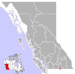
Location of Greenwood in British Columbia
Coordinates: 49°05′24″N118°40′39″W / 49.09000°N 118.67750°W / 49.09000; -118.67750
CountryCanada
Province British Columbia
Region Boundary Country
Regional district Kootenay Boundary
Incorporated1897
Government
  MayorJohn Bolt
  CouncilJessica McLean, Gerry Shaw, Clint Huisman, Jim Nathorst
Area
  Total2.52 km2 (0.97 sq mi)
Elevation
770 m (2,530 ft)
Population
 (2016)
  Total702
  Density280/km2 (720/sq mi)
Time zone UTC-8 (PST)
Zip code
V0H 1J0
Area code(s) 250, 778, 236, 672
Highways 3
Website www.greenwoodcity.com OOjs UI icon edit-ltr-progressive.svg

Greenwood (2021 population 702) is a city in south central British Columbia. It was incorporated in 1897 and was formerly one of the principal cities of the Boundary Country smelting and mining district. [1] It was incorporated as a city originally and has retained that title despite the population decline following the closure of the area's industries.

Contents

The town is served by Greenwood Elementary School which covers grades from K-7. Following grade 7 local students attend Boundary Central Secondary School in nearby Midway.

In 1942, 1,200 Japanese Canadians were sent to Greenwood as part of the Japanese Canadian internment. [2] Among those interned at Greenwood were Isamu and Fumiko Kariya and their son Yasi, the grandparents and uncle of NHL star and Hockey Hall of Fame member Paul Kariya; his father Tetsuhiko (T.K.) was born in internment. [3]

History

In 1886 several mining claims had been staked in a narrow gulch ten miles north of the mouth of Boundary Creek. The ore was high in copper. Ten years later more claims had been staked in the area. These claims gave rise to the city of Greenwood. In 1895 a merchant named Robert Wood erected a log store and named the region Greenwood.

By 1896 there were three hotels, a general store, a livery stable, two assay offices, a mining broker, an opera house, and a dozen other establishments. Greenwood became an incorporated city in 1897. The population climbed to 3,000 by 1899 and a railway called the Columbia and Western Railway reached Greenwood from the east. In 1899 a fire struck Greenwood which gutted several businesses.

Trains at the Mother Lode Mine near Greenwood, 1903 Mother Lode Mine near Greenwood, BC, 1903.jpg
Trains at the Mother Lode Mine near Greenwood, 1903

The BC Copper Company smelter began operation in 1901, servicing ore from the Mother Lode Mine and other mines in the area. Greenwood was the supply center for surrounding camps such as Providence, Copper, Deadwood, Wellington, Central, Skylark and others. The city became the seat of government for the Boundary with one hundred firms in the business district. Greenwood had a newspaper called the "Times" by 1906 another paper called the "Greenwood Ledge".

By 1910 the boom had passed and Greenwood's population was 1,500. At the end of World War I, the demand for copper dropped, and by 1918 the copper market was dead, and the smelter in Greenwood lay idle. The following year it closed down permanently. The collapse of the smelters led to close of mines around the vicinity of Greenwood. Greenwood was on the decline after this period. [4] [5]

Lost mines

Close to Greenwood is the location of Jolly Jack's Lost Mine. Local historian Bill Barlee wrote about Jolly Jack's lost mine. The location of the mine was never found. The Greenwood local museum has written records of Jolly Jack. [6]

Henry Morgan's lost mine is located somewhere around Greenwood. The mine is thought to have been at the headwaters of Boundary Creek, although it has never been found. Local historian Garnet Basque has written about Morgan's lost mine. [7]

Demographics

Historical population
YearPop.±%
1891 1,000    
1901 1,359+35.9%
1911 778−42.8%
1921 371−52.3%
1931 171−53.9%
1941 363+112.3%
1951 809+122.9%
1956 815+0.7%
1961 932+14.4%
1966 911−2.3%
1971 868−4.7%
1976 931+7.3%
1981 856−8.1%
1986 767−10.4%
1991 725−5.5%
1996 784+8.1%
2001 666−15.1%
2006 625−6.2%
2011 708+13.3%
2016 665−6.1%
2021 702+5.6%
Sources: Statistics Canada [8]

In the 2021 Census of Population conducted by Statistics Canada, Greenwood had a population of 702 living in 375 of its 448 total private dwellings, a change of

Arts and culture

Greenwood was featured on the historical television series Gold Trails and Ghost Towns, Season 2, Episode 1. Greenwood was one of the filming locations for the theatrical film Snow Falling on Cedars . [2] It was also featured as a town named after the fictional logging magnate of Everett Greenwood in the 2019 Michael Christie novel Greenwood. [10]

See also

Related Research Articles

<span class="mw-page-title-main">Britannia Beach</span> Village in British Columbia, Canada

Britannia Beach is a small unincorporated community in the Squamish-Lillooet Regional District located approximately 55 kilometres north of Vancouver, British Columbia on the Sea-to-Sky Highway on Howe Sound. It has a population of about 300. It includes the nearby Britannia Creek, a small to mid-sized stream that flows into Howe Sound that was historically one of North America's most polluted waterways.

Neville Langrell "Bill" Barlee was a Canadian politician who was first elected to the Legislative Assembly of British Columbia as a New Democrat in 1988. He served as Minister of Agriculture, Fisheries and Food from 1991 until 1993 and then as Minister of Small Business, Tourism and Culture from 1993 until 1996.

<span class="mw-page-title-main">Grand Forks, British Columbia</span> City in British Columbia, Canada

Grand Forks is a city in the Boundary Country of the West Kootenay region of British Columbia, Canada. It is located at the confluence of the Granby and Kettle Rivers, a tributary of the Columbia River. The city is just north of the Canada–United States border, approximately 500 km (310 mi) from Vancouver and 200 km (120 mi) from Kelowna and 23 km (14 mi) west of the resort area of Christina Lake by road.

<span class="mw-page-title-main">Sandon, British Columbia</span> Place in British Columbia, Canada

Sandon is in the foothills of the Selkirk Mountains in the West Kootenay region of southeastern British Columbia. The near ghost town lies off BC Highway 31A, and is at the confluence of Sandon Creek into Carpenter Creek. By road, the place is about 14 kilometres (9 mi) east of New Denver and 43 kilometres (27 mi) west of Kaslo.

Greenwood was the name of a provincial electoral district in the Canadian province of British Columbia. It was located in there Boundary Country west of Grand Forks around the city of Greenwood. It first appeared on the hustings in the large redistribution prior to the 1903 election. For the 1924 election it was merged with the Grand Forks riding to form Grand Forks-Greenwood.

<span class="mw-page-title-main">Slocan, British Columbia</span> Village in British Columbia, Canada

The Village of Slocan is in the West Kootenay region of southeastern British Columbia. The former steamboat landing and ferry terminal is at the mouth of Springer Creek, at the foot of Slocan Lake. The locality, on BC Highway 6 is about 69 kilometres (43 mi) by road north of Castlegar and 183 kilometres (114 mi) by road and ferry south of Revelstoke.

The Boundary Country is a historical designation for a district in southern British Columbia lying, as its name suggests, along the boundary between Canada and the United States. It lies to the east of the southern Okanagan Valley and to the west of the West Kootenay. It is often included in descriptions of both of those regions but historically has been considered a separate region. Originally inclusive of the South Okanagan towns of Osoyoos and Oliver, today the term continues in use to refer to the valleys of the Kettle, West Kettle, and Granby Rivers and of Boundary and Rock Creeks and that of Christina Lake and of their various tributaries, all draining the south slope of the Monashee Mountains. The term Boundary District as well as the term Boundary Country can both refer to the local mining division of the British Columbia Ministry of Mines, Energy and Petroleum Resources.

Robert Allan Brown was a well-known and flamboyant prospector and speculator in 19th and early 20th Century in the Canadian province of British Columbia. He was known generally as Volcanic Brown, especially in the province's Kootenay and Boundary districts and in adjoining Eastern Washington, and also as Sunset Brown in the Similkameen District and still also to others as Crazy Brown. His enthusiastic nature contributed to his nickname, and as result of that and his flamboyant personality he was a fixture in mining industry news in a wide region which spanned the British Columbia-United States border.

<span class="mw-page-title-main">Cascade City</span> Ghost town in British Columbia, Canada

Cascade City or Cascade was a Canadian Pacific Railway construction era boom town in the Boundary Country of the West Kootenay region of British Columbia, Canada. Because of its location near the Canada–United States border, it was also called the "Gateway to the Boundary Country".

<span class="mw-page-title-main">Phoenix, British Columbia</span> Place in British Columbia, Canada

Phoenix is a ghost town in the Boundary Country of British Columbia, Canada, 11 km east of Greenwood. Once called the "highest city in Canada" by its citizens it was a booming copper mining community from the late 1890s until 1919. In its heyday it was home to 1,000 citizens and had an opera house, twenty hotels, a brewery and its own city hall. Phoenix's magistrate, Judge Willie Williams, who served there from 1897 until 1913, became famous for his booming declaration, "I am the highest judge, in the highest court, in the highest city in Canada." In 1911, Phoenix's hockey team won the provincial championship and asked for the right to compete for the Stanley Cup, but it was too late to qualify. The Granby Consolidated Mining, Smelting and Power Company operated the Phoenix Mine, a copper mine that produced 13,678,901 tons of ore before operations ceased on June 14, 1919.

Granby Consolidated Mining, Smelting and Power Co. was established by charter to operate in the Boundary region of southern British Columbia. Primarily involved in the mining and smelting of copper, the conglomerate became a publicly traded company. The various corporate operating names within the former group mostly specified the Granby identity.

Anaconda is an unincorporated community south of the confluence of Eholt and Boundary creeks in the Boundary Country region of south central British Columbia. About 43 kilometres (27 mi) west of Grand Forks, and 82 kilometres (51 mi) east of Osoyoos, on Highway 3, the neighbourhood is immediately south of Greenwood.

<span class="mw-page-title-main">Boundary Falls (British Columbia)</span> Waterfall

Boundary Falls is a medium-sized waterfall on Boundary Creek in British Columbia, Canada. Boundary Creek is a tributary of the Kettle River. It is located within a small canyon a little over halfway between Midway & Greenwood, beside the town which was named after the falls, Boundary Falls.

Granite Creek is a creek and townsite in British Columbia located in the Similkameen region. Granite Creek flows north into the Tulameen River and joins that river approximately one and a half miles to the east of Coalmont, British Columbia. It is assumed Granite Creek yielded more than $500,000 in placer gold since its discovery. Gold nuggets worth $50 in value were not unusual in the early years. The creek was mined by Europeans and Chinese. Granite Creek was hydraulicked near its mouth in the 1890s.

Deadwood is a ghost town in British Columbia. Deadwood existed in 1897 and was located several miles west of Greenwood, between Grand Forks and Osoyoos. A number of copper claims in the area gave rise to Deadwood. The copper claims include Big Ledge, Eagle, Butte City, Spoiled Horse, and Mother Lode. The Mother Lode became a great mine although Deadwood disappeared within a few years. Deadwood contained two hotels, a store, a post office and a school. Traces of the Algoma Hotel may still exist, although the town of Deadwood has disappeared.

Corbin is a ghost town in British Columbia, Canada. It was a coal mining community located at the foot of Coal Mountain, south of the Crowsnest Pass in the southern Canadian Rockies.

Boundary Creek is a tributary of the Kettle River in the Boundary Country region of south central British Columbia. The creek is approximately 32 kilometres (20 mi) in length, flowing from the northeast, passing east of Midway, and only the final one-quarter mile (0.40 km) is in northeastern Washington, US.

Skeff Creek is a creek in the Boundary Country region of British Columbia. The creek flows east into July Creek, west of Smelter Lake, Similkameen Division Yale Land District. Skeff Creek used to be called Taylor Creek. The creek has been mined.

Jolly Jack's Lost Mine is a legend about a hidden placer mine supposed to be located in the Boundary Country of British Columbia. The mine has been written about by local historians and various magazines. Many have searched for the lost placer mine of Jolly Jack. It is a local legend in the Boundary Country.

Gold Trails and Ghost Towns is a Canadian historical documentary show, created and produced by television station CHBC-TV in Kelowna, British Columbia for Canadian syndication and hosted by Mike Roberts with historian/storyteller Bill Barlee. The show was filmed in a studio which resembled an old trapper's cabin. Mike and Bill discussed prospectors and the history of British Columbia around 1900.

References

  1. "Greenwood". BC Geographical Names .
  2. 1 2 Timmermans, Tricia (2005). British Columbia Off the Beaten Path. Globe Pequot. p. 109. ISBN   0-7627-3516-3.
  3. Michael, Farber (January 26, 1998). "Two Different Worlds: Superstar Paul Kariya is proud of his heritage but also proud to be an Olympian for Canada, the country that punished his grandparents for being Japanese". Sports Illustrated. Retrieved November 13, 2017.
  4. N.L. Barlee (1973), Gold Creeks and Ghost Towns, Canada West Publications
  5. "Nelson Star, 23 Dec 2014". www.nelsonstar.com. 23 December 2014.
  6. N.L. Barlee (1976), Historic Treasures and Lost Mines of British Columbia. Canada West Publications.
  7. Basque Garnet (2000), Lost Bonanzas of Western Canada, Heritage House
  8. "British Columbia – Municipal Census Populations (1921–2016)". BC Stats. Archived from the original on December 24, 2018. Retrieved May 9, 2013.
  9. "Population and dwelling counts: Canada, provinces and territories, and census subdivisions (municipalities), British Columbia". Statistics Canada. February 9, 2022. Retrieved February 20, 2022.
  10. Christie, Michael, 1976- (2020). Greenwood : a novel (First U.S. ed.). New York. ISBN   978-1-9848-2200-0. OCLC   1107067296.{{cite book}}: CS1 maint: location missing publisher (link) CS1 maint: multiple names: authors list (link) CS1 maint: numeric names: authors list (link)

49°5′28″N118°40′37″W / 49.09111°N 118.67694°W / 49.09111; -118.67694