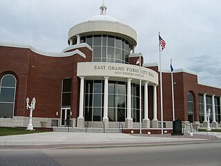
East Grand Forks is a city in Polk County, Minnesota, United States. The population was 9,176 at the 2020 Census, making it the largest community in Polk County.

Grand Forks is the 3rd most populous city in the U.S. state of North Dakota and the county seat of Grand Forks County. According to the 2020 census, the city's population was 59,166. Grand Forks, along with its twin city of East Grand Forks, Minnesota, forms the center of the Grand Forks, ND-MN Metropolitan Statistical Area, which is often called Greater Grand Forks or the Grand Cities.

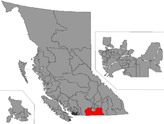
The Regional District of Kootenay Boundary (RDKB) is one of 28 regional districts in the province of British Columbia, Canada. As of the 2016 Canadian census, the population was 31,447. The area is 8,095.62 km2. The RDKB was incorporated in 1966 and consists of eight incorporated municipalities and five unincorporated electoral areas. The regional district's offices are in the City of Trail, with secondary offices in the City of Grand Forks. Other major population centres include the cities of Rossland and Greenwood, and the villages of Fruitvale, Warfield, and Montrose. The region also encompasses electoral areas A, B/Lower Columbia-Old Glory, C/Christina Lake, D/Rural Grand Forks and E/West Boundary including Rock Creek, Bridesville, Beaverdell and Big White Ski Resort.
Highway 41 is a very short cross-border spur in the Regional District of Kootenay Boundary in British Columbia. At just 1.29 km (0.80 mi), it is the shortest numbered highway in the province. It connects State Route 21 at the Carson Canada-U.S. border crossing to a point on the Crowsnest Highway just 3 km (1.9 mi) west of Grand Forks. The highway was given the '41' designation in 1968. The reason the highway wasn't numbered "21" as a continuation of the Washington route, was because that highway number already existed in the Creston area.
British Columbia Highway 395 is a short provincial highway in the Regional District of Kootenay Boundary of British Columbia. It is a cross-border spur that connects with U.S. Route 395 at the Canada–U.S. border crossing near Laurier, Washington. Its northern terminus is at the Crowsnest Highway near Cascade, about 20 km (12 mi) east of Grand Forks.

British Columbia Southern Interior was a federal electoral district in the province of British Columbia, Canada, that had been represented in the House of Commons of Canada from 1997 to 2015.
Grand Forks is the third-largest city in the State of North Dakota, US.
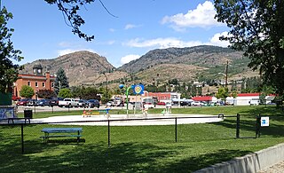
Grand Forks is a city in the Boundary Country of the West Kootenay region of British Columbia, Canada. It is located at the confluence of the Granby and Kettle Rivers, a tributary of the Columbia River. The city is just north of the Canada–United States border, approximately 500 km (310 mi) from Vancouver and 200 km (120 mi) from Kelowna and 23 km (14 mi) west of the resort area of Christina Lake by road.

The Niut Range is 3600 km2 in area. It is a subrange of the Pacific Ranges of the Coast Mountains of British Columbia, although in some classifications it is considered part of the Chilcotin Ranges. The Niut is located in the angle of the Homathko River and its main west fork, Mosley Creek. It is isolated, island-like, by those rivers from its neighbour ranges, as both streams have their source on the Chilcotin Plateau in behind the range. Razorback Mountain is its highest peak.
Greenwood was the name of a provincial electoral district in the Canadian province of British Columbia. It was located in there Boundary Country west of Grand Forks around the city of Greenwood. It first appeared on the hustings in the large redistribution prior to the 1903 election. For the 1924 election it was merged with the Grand Forks riding to form Grand Forks-Greenwood.
Grand Forks was the name of a provincial electoral district in the Canadian province of British Columbia centred on the town of Grand Forks, in the Boundary Country between the Okanagan and Kootenay Countries. The riding first appeared as the result of a redistributing of the former West Kootenay which also created Greenwood, Rossland City, Nelson City, and Ymir in 1903. In 1924, the area of the Grand Forks riding was merged with that of the Greenwood riding to create Grand Forks-Greenwood. The area is currently represented by West Kootenay-Boundary.
Grand Forks-Greenwood was the name of a provincial electoral district in the Canadian province of British Columbia centred on the town of Grand Forks, in the Boundary Country between the Okanagan and Kootenay Countries. The riding first appeared in the 1924 election as the result of a merger of the former ridings of Greenwood and Grand Forks, and lasted until the 1963 election. As of 1966 the area was represented by Boundary-Similkameen. The same area is now part of West Kootenay-Boundary.
Boundary-Similkameen is a provincial riding formed in 2008. It includes the populations of Penticton-Okanagan Valley, West Kootenay-Boundary and Yale-Lillooet. The riding's name corresponds to that of a former riding in the same area, with similar but not identical boundaries.

Midway is in the West Kootenay region of south central British Columbia. The village lies 13 kilometres (8 mi) west of Greenwood and 51 kilometres (32 mi) east of Osoyoos along Highway 3.
The Boundary Country is a historical designation for a district in southern British Columbia lying, as its name suggests, along the boundary between Canada and the United States. It lies to the east of the southern Okanagan Valley and to the west of the West Kootenay. It is often included in descriptions of both of those regions but historically has been considered a separate region. Originally inclusive of the South Okanagan towns of Osoyoos and Oliver, today the term continues in use to refer to the valleys of the Kettle, West Kettle, and Granby Rivers and of Boundary and Rock Creeks and that of Christina Lake and of their various tributaries, all draining the south slope of the Monashee Mountains. The term Boundary District as well as the term Boundary Country can both refer to the local mining division of the British Columbia Ministry of Mines, Energy and Petroleum Resources.

Martin Burrell was a Canadian politician.

Downtown Grand Forks is the original commercial center of Grand Forks, North Dakota, United States. Located on the western bank of the Red River of the North, the downtown neighborhood is situated near the fork of the Red River and the Red Lake River. While downtown is no longer the dominant commercial area of the Greater Grand Forks community, it remains the historic center of Grand Forks. An 80.4-acre (32.5 ha) portion was listed on the National Register of Historic Places in 2005, as Downtown Grand Forks Historic District. Today, downtown Grand Forks is home to many offices, stores, restaurants, and bars.
Bush Pass is a mountain pass in the Canadian Rockies, on the border between the Canadian provinces of Alberta and British Columbia. It is located at the headwaters of the Valenciennes River, formerly known as the South Fork Bush River; the North Fork Bush River is now known as the Bush River.
The Kettle Falls International Railway is a shortline railroad in the U.S. state of Washington and the Canadian province of British Columbia. This OmniTRAX subsidiary operates 44 miles (71 km) of track.
