
The Kootenays or Kootenay is a region of southeastern British Columbia. It takes its name from the Kootenay River, which in turn was named for the Kutenai First Nations people.
Highway 3A is the designation of two segments of highway in the southern part of British Columbia.
Highway 6 is a two-lane highway passing between the Kootenay and Okanagan regions in the province of British Columbia, Canada. It is divided into two parts—the Nelson-Nelway Highway between the Canada–United States border and Nelson, and the Vernon-Slocan Highway between South Slocan and Vernon. Highway 6 is a north–south highway between Nelway and the Needles Ferry and an east–west highway between the Needles Ferry and Vernon; it has a total length of 407 km (253 mi). It first opened in 1941 and, aside from minor realignments along it's concurrences with 3 and 3A, its very winding path through the western Kootenays has not changed since.

Kootenay—Columbia is a federal electoral district in British Columbia, Canada, that has been represented in the House of Commons of Canada since 1997.

Kootenay Lake is a lake located in British Columbia, Canada. It is part of the Kootenay River. The lake has been raised by the Corra Linn Dam and has a dike system at the southern end, which, along with industry in the 1950s–70s, has changed the ecosystem in and around the water. The Kootenay Lake ferry is a year-round toll-free ferry that crosses between Kootenay Bay and Balfour. The lake is a popular summer tourist destination.

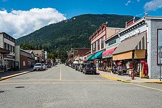
Creston is a town in the Kootenay region of southeastern British Columbia, Canada.

The Regional District of Central Kootenay (RDCK) is a regional district in the province of British Columbia, Canada. As of the 2016 census, the population was 59,517. The area is 22,130.72 square kilometres. The administrative centre is located in the city of Nelson. Other municipalities include the City of Castlegar, the Town of Creston, the Village of Salmo, the Village of Nakusp, the Village of Kaslo, the Village of New Denver, the Village of Silverton, the Village of Ymir and the Village of Slocan.

British Columbia Southern Interior was a federal electoral district in the province of British Columbia, Canada, that had been represented in the House of Commons of Canada from 1997 to 2015.
Yale–Cariboo was a federal electoral district in British Columbia, Canada, that was represented in the House of Commons of Canada from 1896 to 1917.

Kootenay Central is a provincial electoral district for the Legislative Assembly of British Columbia, Canada.
Kaslo-Slocan was the name of a provincial electoral district in the Canadian province of British Columbia centred on the town of Kaslo on Kootenay Lake as well as the mining towns of the "Silvery Slocan". The riding first appeared in the 1924 election as the result of a merger of the former ridings of Kaslo and Slocan, and lasted until the 1963 election.
Kaslo is a village on the west shore of Kootenay Lake in the West Kootenay region of southeastern British Columbia. A member municipality of the Central Kootenay Regional District, the name derives from the adjacent Kaslo River. One travel writer regards it as the "Little Switzerland of Canada."

Selkirk College is a public college founded in 1966 with its main campus in Castlegar, British Columbia, Canada. The college has student housing at its Castlegar and Nelson campuses. Students frequently struggle to find accommodation. The college has seen shrinking enrolment for the past seven years, dropping from 1,987 FTE students in 2015/16 to 1,239 in 2022/23. International students currently account for 11% of total student headcount, a decrease of 3% over the past five years, the lowest rate for a public BC college. Indigenous students comprise 8% of total student numbers.
Winlaw is an unincorporated community adjacent to Winlaw Creek on the east side of the Slocan River in the West Kootenay region of southeastern British Columbia. The locality is on BC Highway 6 about 20 kilometres (12 mi) south of Slocan, and 49 kilometres (30 mi) north of Castlegar.
West Kootenay Transit System is the public transit system in Trail, Castlegar, Nelson, British Columbia and surrounding area. The transit services are operated from Trail, Castlegar, Nelson and serve Rossland, Warfield, Genelle, Montrose, Fruitvale, Salmo, Kaslo, Creston, Nakusp. Funding is provided under a partnership between the Regional District of Kootenay Boundary, Regional District of Central Kootenay and BC Transit. handyDART provides door-to-door transportation for people whose disability prevents them from using conventional bus service.

The Moyie is a paddle steamer sternwheeler that operated on Kootenay Lake in British Columbia from 1898 until 1957.
British Columbia Highway 3, officially named the Crowsnest Highway, is an 841-kilometre (523 mi) highway that traverses southern British Columbia, Canada. It runs from the Trans-Canada Highway (Highway 1) at Hope to Crowsnest Pass at the Alberta border and forms the western portion of the interprovincial Crowsnest Highway that runs from Hope to Medicine Hat, Alberta. The highway is considered a Core Route of the National Highway System.
Wynndel is an unincorporated community adjacent to Duck Creek, east of the Kootenay River, in the West Kootenay region of southeastern British Columbia. The locality, on BC Highway 3A, is by road about 11 kilometres (7 mi) north of Creston and 128 kilometres (80 mi) southeast of Nelson.
Crawford Bay is a community of approximately 350 people, situated in the Purcell mountain range on the eastern shore of Kootenay Lake in the West Kootenay region of southeastern British Columbia. This location on Highyway 3A is 76 kilometres (47 mi) by road north of Creston and 48 kilometres (29.8 mi) by road and ferry northeast across Kootenay Lake from Nelson.
