
Nelson is a city located in the Selkirk Mountains on the West Arm of Kootenay Lake in the Southern Interior of British Columbia, Canada. Known as "The Queen City", and acknowledged for its impressive collection of restored heritage buildings from its glory days in a regional silver rush, Nelson is one of the three cities forming the commercial and population core of the West Kootenay region, the others being Castlegar and Trail. The city is the seat of the Regional District of Central Kootenay. It is represented in the provincial legislature by the riding of Nelson-Creston, and in the Parliament of Canada by the riding of Kootenay—Columbia.

Sparwood is a district municipality in the Canadian province of British Columbia. It is the second-largest community on the Elk River.

The Kootenays or Kootenay is a region of southeastern British Columbia. It takes its name from the Kootenay River, which in turn was named for the Kutenai First Nations people.
Highway 3A is the designation of two segments of highway in the southern part of British Columbia.

The Kootenay River or Kootenai River is a major river of the Northwest Plateau in southeastern British Columbia, Canada, and northern Montana and Idaho in the United States. It is one of the uppermost major tributaries of the Columbia River, the largest North American river that empties into the Pacific Ocean. The Kootenay River runs 781 kilometres (485 mi) from its headwaters in the Kootenay Ranges of the Canadian Rockies, flowing from British Columbia's East Kootenay region into northwestern Montana, then west into the northernmost Idaho Panhandle and returning to British Columbia in the West Kootenay region, where it joins the Columbia at Castlegar.
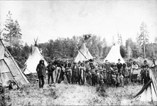
The Kutenai, also known as the Ktunaxa, Ksanka, Kootenay and Kootenai, are an indigenous people of Canada and the United States. Kutenai bands live in southeastern British Columbia, northern Idaho, and western Montana. The Kutenai language is a language isolate, thus unrelated to the languages of neighboring peoples or any other known language.

Kootenay—Columbia is a federal electoral district in British Columbia, Canada, that has been represented in the House of Commons of Canada since 1997.

Kootenay Lake is a lake located in British Columbia, Canada. It is part of the Kootenay River. The lake has been raised by the Corra Linn Dam and has a dike system at the southern end, which, along with industry in the 1950s–70s, has changed the ecosystem in and around the water. The Kootenay Lake ferry is a year-round toll-free ferry that crosses between Kootenay Bay and Balfour. The lake is a popular summer tourist destination.

Creston is a town in the Kootenay region of southeastern British Columbia, Canada.

The Regional District of East Kootenay (RDEK) is a regional district in the Canadian province of British Columbia, Canada. In the 2016 census, the population was 60,439. Its area is 27,542.69 km2 (10,634.29 sq mi). The regional district offices are in Cranbrook, the largest community in the region. Other important population centres include the cities of Kimberley and Fernie, and the district municipality of Invermere and Sparwood. Despite its name, the regional district does not include all of the region known as the East Kootenay, which includes the Creston Valley and the east shore of Kootenay Lake.

The British Columbia Interior, popularly referred to as the BC Interior or simply the Interior, is a geographic region of the Canadian province of British Columbia. While the exact boundaries are variously defined, the British Columbia Interior is generally defined to include the 14 regional districts that do not have coastline along the Pacific Ocean or Salish Sea, and are not part of the Lower Mainland. Other boundaries may exclude parts of or even entire regional districts, or expand the definition to include the regional districts of Fraser Valley, Squamish–Lillooet, and Kitimat–Stikine.
British Columbia Highway 3, officially named the Crowsnest Highway, is an 841-kilometre (523 mi) highway that traverses southern British Columbia, Canada. It runs from the Trans-Canada Highway (Highway 1) at Hope to Crowsnest Pass at the Alberta border and forms the western portion of the interprovincial Crowsnest Highway that runs from Hope to Medicine Hat, Alberta. The highway is considered a Core Route of the National Highway System.

The Creston Valley Wildlife Management Area is a Canadian river delta wetland and Wildlife Management Area near Creston in south-central British Columbia, on the floodplain of the Kootenay River at the south end of Kootenay Lake. Predominantly marshland, it was classified as a wetland of international importance on February 21, 1994, and is also a globally significant Important Bird Area. It is one of the "few significant agricultural areas of the province", and is in the Montane Cordillera. It stretches north along Kootenay Lake for approximately 20 km, and south to the United States border. It is both the only breeding site of the Forster's tern and the only site with leopard frogs in the province, as well as one of the few Canadian habitats for the Coeur D'Alene salamander. Creston Valley provides staging and nesting areas for migratory birds on the Pacific Flyway.

The Goat River is a tributary of the Kootenay River in the Canadian province of British Columbia. The river meets the Kootenay near the town of Creston. The Goat River Dam, constructed in the 1930s, was an early source of electricity for the town. Before dikes were built, the river was a major source of spring flooding in the Creston valley.

The Baillie-Grohman Canal was a shipping canal between the headwaters of the Columbia River and the upper Kootenay River in the East Kootenay region of British Columbia at a place now known as Canal Flats, BC. The construction of the canal was required by the provincial government of British Columbia as a condition of the canal's promoter receiving substantial land concessions from the provincial government of British Columbia in the area of Creston, BC. The promoter, William Adolf Baillie-Grohman (1851–1921), was a wealthy adventurer, hunter author, and business promoter. He declared the canal to be complete in 1889. The canal was an expensive failure, being used only three times during its entire existence. In 1902, on the last use by a vessel, the sternwheeler North Star, the sternwheeler's captain, Frank P. Armstrong deliberately blew out the canal's lower lock gates with dynamite to allow the transit of his vessel.
The Lower Kootenay First Nation is a First Nation based in the East Kootenay region of British Columbia. In the British Columbia Treaty Process They are part of the Ktunaxa Kinbasket Tribal Council.
Crawford Bay is a community of approximately 350 people, situated in the Purcell mountain range on the eastern shore of Kootenay Lake in the West Kootenay region of southeastern British Columbia. This location on Highyway 3A is 76 kilometres (47 mi) by road north of Creston and 48 kilometres (29.8 mi) by road and ferry northeast across Kootenay Lake from Nelson.

The Porthill-Rykerts Border Crossing connects the town of Bonners Ferry, Idaho with Creston, British Columbia on the Canada–US border. Idaho State Highway 1 on the American side joins British Columbia Highway 21 on the Canadian side, which continues north towards Creston. The Porthill-Rykerts Border Crossing is used as the American Port only; Rykerts acts as the Canadian Crossing.
