
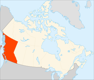
British Columbia is the westernmost province of Canada. Situated in the Pacific Northwest between the Pacific Ocean and the Rocky Mountains, the province has a diverse geography, with rugged landscapes that include rocky coastlines, sandy beaches, forests, lakes, mountains, inland deserts and grassy plains. British Columbia borders the province of Alberta to the east; the territories of Yukon and Northwest Territories to the north; the U.S. states of Washington, Idaho and Montana to the south, and Alaska to the northwest. With an estimated population of over 5.6 million as of 2024, it is Canada's third-most populous province. The capital of British Columbia is Victoria, while the province's largest city is Vancouver. Vancouver and its suburbs together make up the third-largest metropolitan area in Canada, with the 2021 census recording 2.6 million people in Metro Vancouver. British Columbia is Canada's third-largest province in terms of total area, after Quebec and Ontario.

Lillooet is a district municipality in the Squamish-Lillooet region of southwestern British Columbia. The town is on the west shore of the Fraser River immediately north of the Seton River mouth. On BC Highway 99, the locality is by road about 100 kilometres (62 mi) northeast of Pemberton, 64 kilometres (40 mi) northwest of Lytton, and 172 kilometres (107 mi) west of Kamloops.

The Village of Pouce Coupe is a small town in northeastern British Columbia, Canada, and a member municipality of the Peace River Regional District. It was originally named 'Pouskapie's Prairie', after the name of the local native band chief. The 2.06-square-kilometre (0.80 sq mi) municipality is home to 792 residents.

Burns Lake is a rural village in the North-western-Central Interior of British Columbia, Canada, incorporated in 1923. The village had a population of 1,659 as of the 2021 Census.
Thompson Rivers University is a public teaching and research university offering undergraduate and graduate degrees and vocational training. Its main campus is in Kamloops, British Columbia, Canada, and its name comes from the two rivers which converge in Kamloops, the North Thompson and South Thompson. The university has a satellite campus in Williams Lake, BC and a distance education division called TRU-Open Learning. It also has several international partnerships through its TRU World division. TRU is accredited by the Northwest Commission on Colleges and Universities (NWCCU) at the associate, baccalaureate and master's degree levels.

Lytton is a village of about 250 residents in southern British Columbia, Canada, on the east side of the Fraser River and primarily the south side of the Thompson River, where it flows southwesterly into the Fraser. The community includes the Village of Lytton and the surrounding community of the Lytton First Nation, whose name for the place is Camchin, also spelled Kumsheen.

The University of the Fraser Valley (UFV), formerly known as University College of the Fraser Valley and Fraser Valley College, is a public university with campuses in Abbotsford, Chilliwack, Mission and Hope, British Columbia, Canada. Founded in 1974 as Fraser Valley College, it was a response to the need for expanded vocational training in the communities of the Fraser Valley. In 1991, it became a university college, with degree-granting status. As the University College of the Fraser Valley, it grew rapidly, becoming one of the largest university colleges in Canada.
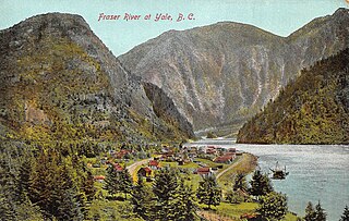
Yale is an unincorporated town in the Canadian province of British Columbia, which grew in importance during the Fraser Canyon Gold Rush.

Seton Portage is a community on a narrow strip of land between Anderson Lake and Seton Lake in Squamish-Lillooet Regional District, British Columbia. The community is home to two Seton Lake First Nation communities at either end of the portage and a non-native recreational community between them. Local services include a post office, fire department, library, and general store, among other small businesses. The community is also the location of Seton Portage Historic Provincial Park, a small provincial park protecting a historically significant stretch of railway.
Yale-Lillooet was a provincial electoral district for the Legislative Assembly of British Columbia, Canada.

The District of Taylor is a district municipality in northeastern British Columbia, Canada, located at mile 36 of the Alaska Highway. Taylor, a member municipality of the Peace River Regional District, covers an area of about 17 km2 with 1,317 residents as of 2021.

Golden Ears Provincial Park is a 555.9 square kilometres (214.6 sq mi) provincial park in British Columbia, Canada. It is named after the prominent twin peaks, which are commonly referred to as Golden Ears. The park was originally part of Garibaldi Provincial Park but was split off as a separate park in 1967. The area was logged extensively in the 1920s by the Lougheed and Abernathy Logging Company. Many recreational attractions are found within the park. Golden Ears Provincial Park is a protected area that contains many endangered species of flora and fauna.
Seton Portage Historic Provincial Park is a historic provincial park located in the community of Seton Portage, British Columbia, Canada. It was established on March 29, 1972 to commemorate the location of the first railway in the province of British Columbia.

Britannia Community Secondary School is a public community secondary school located in the Grandview–Woodland neighbourhood on the east-side of Vancouver, British Columbia. The school educates its students using a district-wide block schedule program that alternates four blocks every two days. Students are subject to eight different blocks in total.

Robert Cecil Palmer Secondary School, is a public, co-educational secondary school situated in Richmond, British Columbia, Canada which educates students in grades 8–12. Palmer Secondary School is one of the many schools under the Richmond School District. It is the only school in Richmond to offer the Pre-AP Incentive Program, the ACE-IT plumbing program and, previously, the Palmer Hockey Academy. The Richmond Virtual School is also hosted in the Palmer building.

The Lil'wat First Nation, a.k.a. the Lil'wat Nation or the Mount Currie Indian Band, is a First Nation band government located in the southern Coast Mountains region of the Interior of the Canadian province of British Columbia. It is a member of the Lillooet Tribal Council, which is the largest grouping of band governments of the St'at'imc or Stl'atl'imx people. Other St'at'imc governments include the smaller In-SHUCK-ch Nation on the lower Lillooet River to the southwest, and the independent N'quatqua First Nation at the near end of Anderson Lake from Mount Currie, which is the main reserve of the Lil'wat First Nation, and also one of the largest Indian reserves by population in Canada.
Higher education in British Columbia is delivered by 25 publicly funded institutions that are composed of eleven universities, eleven colleges, and three institutes. This is in addition to three private universities, five private colleges, and six theological colleges. There are also an extensive number of private career institutes and colleges. Over 297,000 students were enrolled in post-secondary institutions in British Columbia in the 2019-2020 academic year.
Skatin is a community of under 100 persons in Skatin First Nations, aka the Skatin Nations, a Band government of the larger Band of the In-SHUCK-ch Nation, part of the St'at'imc people who are also referred to as Lower Stl'atl'imx. Skatin, the official new name, reverts to the traditional pre-colonial/pre-Columbian name. The alternate past name still commonly used by outsiders, Skookumchuck, is the St'at'imcets version of the Chinook Jargon Skookumchuck, meaning Strong Waters, i.e. rapids. The town site is 4 km south of T'sek Hot Spring, formerly named both Saint Agnes Well and Skookumchuck Hot Springs. The community is 28 km south of the outlet of Lillooet Lake on the east side of the Lillooet River. It is approximately 75 km south of the town of Pemberton and the large reserve of the Lil'wat branch of the St'at'imc at Mount Currie, British Columbia. See Skatin First Nations for details about the complicated Band(s) structure.

The Stlʼatlʼimx Tribal Police Service (STPS) is the police force for St'at'imc aboriginal peoples of British Columbia. The STPS is the only aboriginal police service in British Columbia. Their officers are appointed as designated provincial constables, and have full police powers on and off-duty throughout the province. They are based in Lillooet and Mount Currie.
Education in British Columbia comprises public and private primary and secondary schools throughout the province. Like most other provinces in Canada, education is compulsory from ages 6–16, although the vast majority of students remain in school until they graduate from high school at the age of 18. In 2020, 86% of students in British Columbia graduated from high school within six years of entering grade 8. It is also common for children to attend kindergarten at the age of 5, it is increasingly common for even younger children to attend pre-school or early learning programs before their formal school age years.