See also
| | This British Columbia school-related article is a stub. You can help Wikipedia by expanding it. |
| School District 85 Vancouver Island North | |
|---|---|
| Location | |
Port Hardy Port Hardy, Port McNeill, Port Alice, Alert Bay, Sointula in Vancouver Island Canada | |
| District information | |
| Superintendent | Mr Scott Benwell |
| Schools | 11 |
| Budget | CA$17.9 million |
| Students and staff | |
| Students | 1530 |
| Other information | |
| Website | sd85 |
School District 85 Vancouver Island North is a school district in British Columbia. It is based in the town of Port Hardy. It provides service to the communities northern tip of Vancouver Island including Port McNeill and Woss as well as the adjacent smaller islands such as Alert Bay.
| School | Location | Grades |
|---|---|---|
| A J Elliott Elementary School | Sointula | K-7 |
| Alert Bay Elementary School | Alert Bay | K-7 |
| Cheslakees Elementary School | Port McNeill | K-5 |
| Continuing Ed SD 85 | Port Hardy | 11-12 |
| Eagle View Elementary School | Port Hardy | K-7 |
| Echo Bay Elementary School (Closed) | Simoom Sound | K-5 |
| Eke Me-Xi School | Port Hardy | 9-11 |
| Fort Rupert Elementary School | Port Hardy | K-7 |
| North Island Secondary School | Port McNeill | 8-12 |
| Port Hardy Secondary School | Port Hardy | 8-12 |
| Quatsino Elementary School (Closed) | Quatsino | K-9 |
| Robert Scott Elementary School (Closed) | Port Hardy | K-7 |
| San Josef Elem-Jr Secondary School (Closed) | Holberg | K-6 |
| Sea View Elem-Jr Secondary School | Port Alice | K-10 |
| Sunset Elementary School | Port McNeill | K-7 |
| Woss Lake Elementary School | Woss | K-7 |
| | This British Columbia school-related article is a stub. You can help Wikipedia by expanding it. |

British Columbia is the westernmost province of Canada. Situated between the Pacific Ocean and the Rocky Mountains, the province has a diverse geography, with rugged landscapes that include rocky coastlines, sandy beaches, forests, lakes, mountains, inland deserts and grassy plains. British Columbia borders the province of Alberta to the east; the territories of Yukon and Northwest Territories to the north; the U.S. states of Washington, Idaho and Montana to the south, and Alaska to the northwest. With an estimated population of over 5.6 million as of 2024, it is Canada's third-most populous province. The capital of British Columbia is Victoria, while the province's largest city is Vancouver. Vancouver and its suburbs together make up the third-largest metropolitan area in Canada, with the 2021 census recording 2.6 million people in Metro Vancouver.

The Lower Mainland is a geographic and cultural region of the mainland coast of British Columbia that generally comprises the regional districts of Metro Vancouver and the Fraser Valley. Home to approximately 3.05 million people as of the 2021 Canadian census, the Lower Mainland contains sixteen of the province's 30 most populous municipalities and approximately 60% of the province's total population.

Vancouver is a major city in western Canada, located in the Lower Mainland region of British Columbia. As the most populous city in the province, the 2021 Canadian census recorded 662,248 people in the city, up from 631,486 in 2016. The Metro Vancouver area had a population of 2.6 million in 2021, making it the third-largest metropolitan area in Canada. Greater Vancouver, along with the Fraser Valley, comprises the Lower Mainland with a regional population of over 3 million. Vancouver has the highest population density in Canada, with over 5,700 people per square kilometre, and fourth highest in North America.

Vancouver Island is an island in the northeastern Pacific Ocean and part of the Canadian province of British Columbia. The island is 456 km (283 mi) in length, 100 km (62 mi) in width at its widest point, and 32,100 km2 (12,400 sq mi) in total area, while 31,285 km2 (12,079 sq mi) are of land. The island is the largest by area and the most populous along the west coasts of the Americas.

Nanaimo is a city of about 100,000 on the east coast of Vancouver Island, in British Columbia, Canada. "The Harbour City" was previously known as the "Hub City", which was attributed to its original layout design with streets radiating from the shoreline like the spokes of a wagon wheel, and to its relatively central location on Vancouver Island. Nanaimo is the headquarters of the Regional District of Nanaimo.

New Westminster is a city in the Lower Mainland region of British Columbia, Canada, and a member municipality of the Metro Vancouver Regional District. It was founded by Major-General Richard Moody as the capital of the Colony of British Columbia in 1858 and continued in that role until the Mainland and Island colonies were merged in 1866. It was the British Columbia Mainland's largest city from that year until it was passed in population by Vancouver during the first decade of the 20th century.

Port Alberni is a city located on Vancouver Island in the province of British Columbia, Canada. The city lies within the Alberni Valley at the head of the Alberni Inlet, Vancouver Island's longest inlet. It is the location of the head offices of the Alberni-Clayoquot Regional District. Port Alberni currently has a total population of 18,259.

Prince Rupert is a port city in the province of British Columbia, Canada. Its location is on Kaien Island near the Alaskan panhandle. It is the land, air, and water transportation hub of British Columbia's North Coast, and has a population of 12,220 people as of 2016.

Port McNeill is a town in the North Island region of Vancouver Island, British Columbia, Canada on Vancouver Island's northeast shore, on Queen Charlotte Strait. Originally a base camp for loggers, it became a settlement in 1936. It was named after Captain William Henry McNeill of the Hudson's Bay Company.

Ucluelet is a district municipality on the Ucluelet Peninsula, on the west coast of Vancouver Island in British Columbia, Canada. Ucluelet comes from Yuułuʔił which means "people of the safe harbour" in the indigenous Nuu-chah-nulth language and is the homeland of the Yuułuʔiłʔatḥ. As of 2021, its population was 2,066, a 20.3% increase from 1,717 in 2016.

Sir James Douglas, was a Canadian fur trader and politician who became the first Governor of the Colony of British Columbia. He is often credited as "The Father of British Columbia". He was instrumental to the resettlement of 35 African Americans fleeing a life of racial persecution in San Francisco who arrived in the province aboard the steamship Commodore in what later became known as the Pioneer Committee. In 1863, Douglas was knighted by Queen Victoria for his services to the Crown.
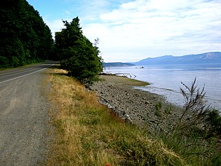
The British Columbia Coast, popularly referred to as the BC Coast or simply the Coast, is a geographic region of the Canadian province of British Columbia. As the entire western continental coastline of Canada along the Pacific Ocean is in the province, it is synonymous with being the West Coast of Canada.

Alert Bay is a village on Cormorant Island, near the town of Port McNeill on northeast Vancouver Island, in the Regional District of Mount Waddington, British Columbia, Canada.

The Colony of British Columbia was a crown colony in British North America from 1858 until 1866 that was founded by Richard Clement Moody, who was selected to 'found a second England on the shores of the Pacific', who was Chief Commissioner of Lands and Works for British Columbia and the first Lieutenant-Governor of British Columbia. Prior to the arrival of Moody's Royal Engineers, Columbia Detachment, the Colony's supreme authority was its Governor James Douglas, who was the Governor of the neighbouring colony of Vancouver Island.
Mill Bay is a commuter town of about 7,200 people located on Vancouver Island, British Columbia, Canada, about 30 km (19 mi) north of Victoria, the capital. It is part of the Cowichan Valley Regional District.
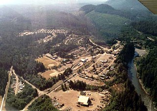
Woss, also commonly known as Woss Lake after the nearby lake of the same name, is a small village in the Nimpkish Valley, located 75 km (47 mi) southeast of Port McNeill and 128 km (80 mi) north of Campbell River on Highway 19, in northeastern Vancouver Island, British Columbia, Canada. The estimated population of Woss and the Nimpkish Valley is 200. The town of Woss lies about 3 km north of Woss Lake, a long, narrow lake stretching about 10 km in a primarily north-south direction with a maximum width of about one km, the southern portion of which is part of Woss Lake Provincial Park.
This is a timeline of the history of Vancouver.
An electoral redistribution in British Columbia was undertaken by the BC Electoral Boundaries Commission beginning in 2014 and was formalized by the passage of Bill 42, the 2015 Electoral Districts Act, during the 40th British Columbia Parliament. The act came into effect on November 17, 2015. The redistribution added two seats to the previous total, increasing the number of MLAs in the province from 85 to 87. The electoral boundaries came into effect for the 2017 election. The next redistribution is required to occur following the 2020 British Columbia general election.