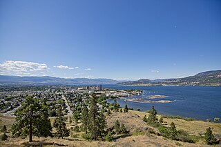
Kelowna is a city on Okanagan Lake in the Okanagan Valley in the southern interior of British Columbia, Canada. It serves as the head office of the Regional District of the Central Okanagan. The name Kelowna derives from an Okanagan language word for "grizzly bear".

The Kettle Valley Railway was a subsidiary of the Canadian Pacific Railway (CPD) that operated across southern British Columbia, west of Midway running to Rock Creek, then north to Myra Canyon, down to Penticton over to Princeton, Coalmont, Brookmere, Coquihalla and finally Hope where it connected to the main CPR line.
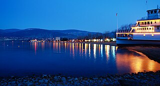
Penticton is a city in the Okanagan Valley of the Southern Interior of British Columbia, Canada, situated between Okanagan and Skaha lakes. In the 2016 Canadian Census, its population was 33,761, while its census agglomeration population was 43,432.

Okanagan Lake is a large, deep lake in the Okanagan Valley of British Columbia, Canada. The lake is 135 km (84 mi) long, between 4 and 5 km wide, and has a surface area of 348 km2.

The Okanagan, also known as the Okanagan Valley and sometimes as the Okanagan Country, is a region in the Canadian province of British Columbia defined by the basin of Okanagan Lake and the Canadian portion of the Okanagan River. It is part of the Okanagan Country, extending into the United States as Okanogan County in north-central Washington. According to the 2016 Canadian census, the region's population is 362,258. The primary city is Kelowna.
Highway 33 is a minor two- to four-lane highway connecting the Boundary Country and Okanagan regions of British Columbia, Canada. Highway 33, which is 129 km (80 mi) long, connects Rock Creek, on the Crowsnest Highway, north to Kelowna, on the Okanagan Highway, partially following the West Kettle River. It is also the main access to the Big White Ski Resort, which is near the apex of the pass between the head of the West Kettle and metropolitan Kelowna. The only other visible community on Highway 33 is Beaverdell, 48 km (30 mi) north of Rock Creek. Highway 33 opened in 1970.

Summerland is a town on the west side of Okanagan Lake in the interior of British Columbia, Canada. The district is between Peachland to the north and Penticton to the south. The largest centre in the region is Kelowna, approximately 50 km (31 mi) to the north, and Vancouver is approximately 425 km (264 mi) away to the west. The district is famous for "Bottleneck drive", a system of roads connecting various wineries.

Princeton is a town in the Similkameen region of southern British Columbia, Canada. It lies just east of the Cascade Mountains, which continue south into Washington, Oregon and California. The Tulameen and Similkameen Rivers converge here. At the 2016 census, the population was 2,828.

The Monashee Mountains are a mountain range lying mostly in British Columbia, Canada, extending into the U.S. state of Washington. They stretch 530 km (329 mi) from north to south and 150 km (93 mi) from east to west. They are a sub-range of the Columbia Mountains. The highest summit is Mount Monashee, which reaches 3,274 m (10,741 ft). The name is from the Scottish Gaelic monadh and sìth, meaning "moor" and "peace".

Grand Forks, population 4,049, is a city in the Boundary Country of the West Kootenay region of British Columbia, Canada. It is located at the confluence of the Granby and Kettle Rivers, a tributary of the Columbia River. The city is just north of the Canada–United States border, approximately 500 km (310 mi) from Vancouver and 200 km (120 mi) from Kelowna and 23 km (14 mi) west of the resort area of Christina Lake by road.

Keremeos is a village in the Southern Interior of British Columbia, Canada. The name originated from the Similkameen dialect of the Okanagan language word "Keremeyeus" meaning "creek which cuts its way through the flats" referring to Keremeos Creek which flows down from the Upper Benchlands to the Similkameen River that runs by the village.
School District 51 Boundary is a school district in British Columbia. Centred in Grand Forks, it covers an area west to the outskirts of Kelowna, British Columbia and all along the border with the United States. This includes the communities of Midway, Greenwood, Beaverdell, and Rock Creek.
The Boundary Country is a historical designation for a district in southern British Columbia lying, as its name suggests, along the boundary between Canada and the United States. It lies to the east of the southern Okanagan Valley and to the west of the West Kootenay. It is often included in descriptions of both of those regions but historically has been considered a separate region. Originally inclusive of the South Okanagan towns of Osoyoos and Oliver, today the term continues in use to refer to the valleys of the Kettle, West Kettle, and Granby Rivers and of Boundary and Rock Creeks and that of Christina Lake and of their various tributaries, all draining the south slope of the Monashee Mountains The term Boundary District as well as the term Boundary Country can both refer to the local mining division of the British Columbia Ministry of Mines, Energy and Petroleum Resources.
The Okanagan Highland is an elevated hilly plateau area in British Columbia, Canada, and the U.S. state of Washington. Rounded mountains with elevations up to 8,000 ft (2,400 m) above sea level and deep, narrow valleys are characteristic of the region.
Lumby is a small community of 1,731 people, located near the edge of the Monashee Mountains. It is mainly a logging, manufacturing and agriculture community.

The Okanagan Country, also known as the Okanagan Valley, is a region located in the Canadian province of British Columbia, and the U.S. state of Washington, defined by the basin of Okanagan Lake and the Okanagan River. With an estimated 400,000 residents, the Okanagan Country spans from the Thompson Plateau near Grindrod, British Columbia in the Okanagan to the Okanagan Highland near Douglas County, Washington in the Okanogan. The largest city in the Canadian portion is Kelowna, with a metropolitan population of 194,882 residents as of 2016, while the largest city in the American portion is Omak, with 4,881 residents as of 2011. The region took its current name in honor of the Okanagan term, ukʷnaqín. The mild climate and close proximity to lakes, rivers and mountainous regions make the Okanagan Country an outdoor recreational destination. The region's economy is dominated by the primary sector industries of agriculture and forestry, although economic diversification has also occurred with retirement communities and recreational tourism. The American portion is considered to be more remote than the Canadian division, with approximately 10 percent of the population.

West Kelowna, formerly known as Westbank and colloquially known as Westside, is a city in British Columbia's Okanagan Valley. The city encompasses several distinct neighbourhoods, including Casa Loma, Gellatly, Glenrosa, Lakeview Heights, Shannon Lake, Smith Creek, Rose Valley, Westbank, and West Kelowna Estates. West Kelowna had an estimated population of 34,883 as of December 31, 2018.
The Beaverdell Range is a subrange of the Okanagan Highland in the Southern Interior of British Columbia, located between the West Kettle and Kettle Rivers, and running nearly due south from Big White Mountain, which is its highest summit, and the highest in the Okanagan Highland, and lies near the head of the Kettle.

Rock Creek is an unincorporated settlement in the Boundary Country of the Southern Interior of British Columbia, Canada. Located at the confluence of the Kettle River with the eponymous Rock Creek, site of the Rock Creek Gold Rush of 1860, the community also lies at the junction of British Columbia Highway 33 and British Columbia Highway 3, otherwise known as the Crowsnest Highway, which runs across the south of the province.

Okanagan dry forests is a temperate coniferous forest ecoregion in the Pacific Northwest of North America, as defined by the World Wildlife Fund (WWF) categorization system. It is closely associated with the Okanagan region of British Columbia and Washington.

