
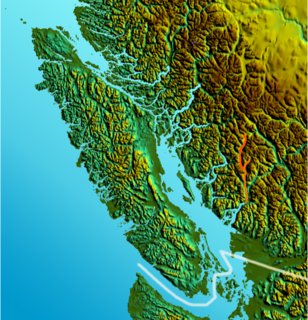
The Squamish River is a short but very large river in the Canadian province of British Columbia. Its drainage basin is 3,328 square kilometres (1,285 sq mi) in size. The total length of the Squamish River is approximately 80 kilometres (50 mi).
The Elaho River is a c.70 km long river beginning in the Coast Mountains northwest of the towns of Whistler and Pemberton, British Columbia. It is a tributary of the Squamish River and is known for its whitewater rafting and kayaking as well as for the intense alpine scenery lining its route.
The Mamquam River is a c.35 km tributary of the Squamish River.

The Chilcotin River /tʃɪlˈkoʊtɪn/ located in Southern British Columbia, Canada is a 241 km (150 mi) long tributary of the Fraser River. The name Chilcotin comes from Tŝilhqot’in, meaning "ochre river people," where ochre refers to the mineral used by Tŝilhqot’in Nation and other Indigenous communities as a base for paint or dye. The Chilcotin River, Chilko River and Lake, and Taseko River and Lake make up the Chilcotin River watershed. This 19,200 km2 (7,400 sq mi) watershed drains the Chilcotin Plateau which reaches north to south from the Nechako Plateau to Bridge River county and east to west from Fraser River to the Coast Mountains. It is also one of twelve watersheds that make up the Fraser River Basin. Made up of seven major tributaries, Chilcotin River starts northeast of Itcha Mountain, flowing southeast until it joins the Fraser River south of Williams Lake, 22 km (14 mi) upstream from Gang Ranch.

The Klinaklini River is one of the major rivers of the Pacific Ranges section of the Coast Mountains in the Canadian province of British Columbia. It originates in the Pantheon Range and empties into the head of Knight Inlet.
Big Creek is a roughly 120-kilometre (75 mi) long tributary of British Columbia's Chilcotin River.
The Boundary Country is a historical designation for a district in southern British Columbia lying, as its name suggests, along the boundary between Canada and the United States. It lies to the east of the southern Okanagan Valley and to the west of the West Kootenay. It is often included in descriptions of both of those regions but historically has been considered a separate region. Originally inclusive of the South Okanagan towns of Osoyoos and Oliver, today the term continues in use to refer to the valleys of the Kettle, West Kettle, and Granby Rivers and of Boundary and Rock Creeks and that of Christina Lake and of their various tributaries, all draining the south slope of the Monashee Mountains The term Boundary District as well as the term Boundary Country can both refer to the local mining division of the British Columbia Ministry of Mines, Energy and Petroleum Resources.

The Kettle River is a 281-kilometre (175 mi) tributary of the Columbia River, encompassing a 10,877-square-kilometre (4,200 sq mi) drainage basin, of which 8,228 square kilometres (3,177 sq mi) are in southern British Columbia, Canada and 2,649 square kilometres (1,023 sq mi) in northeastern Washington, US.
The Kitwanga River is a tributary of the Skeena River near Hazelton in northwestern British Columbia, Canada, joining that stream at the community of Kitwanga (Gitwangak), which means "people of the place of rabbits".

The Kitimat River is a river in the Canadian province of British Columbia. It originates in the Kitimat Ranges, near the sources of the Dala River, Kemano River, Atna River, and Clore River. It flows in a curve north, then west, then south, emptying into Kitimat Arm at the head of Douglas Channel, at the town of Kitimat.
Ashlu Creek is a short and swift river-like creek in British Columbia. It is a tributary of the Squamish River and enters it about 24.3 km northwest of Squamish.
The Rainy River is a short river that enters the Thornbrough Channel at Port Mellon, British Columbia, Canada. While it does come close to doing so, it never enters Tetrahedron Provincial Park.
The Stawamus River is a small, creek-like river in British Columbia. It enters the Howe Sound east of the mouth of the Squamish River.
Clendinning Creek is a river in British Columbia. It is the largest tributary of the Elaho River. It is located entirely within Clendinning Provincial Park.
The Tzoonie River is a remote, short river that enters the head of the Narrows Inlet about 36.6 km north of Sechelt, British Columbia.
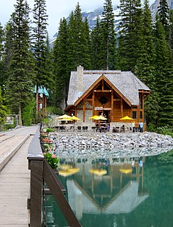
The Emerald River is a short river in British Columbia. It is about 6.5 kilometres (4.0 mi) long and drains the waters of Emerald Lake to the Kicking Horse River. The river exits the lake's south end and flows in a southern direction for about 6.5 kilometres (4.0 mi) to its mouth, which is at almost exactly the same place as the mouth of the Amiskwi River. It picks up three named tributaries; Hamilton Creek, Russell Creek and Kendel Creek.
The Kiwetinok River is a short river in British Columbia. It is the largest tributary of the Amiskwi River.
Kanaka Creek is a tributary of the Fraser River, in the Canadian province of British Columbia. It flows through Maple Ridge, a district municipality at the eastern edge of Metro Vancouver.
The Barrière River is a tributary of the North Thompson River, one of the main tributaries of the Fraser River, in the Canadian province of British Columbia. It flows through the Shuswap Highland region north of Kamloops. Its name in Secwepemctsín is St́yelltsecwétkwe.
The Dudidontu River is a tributary of the Nahlin River in northwest part of the province of British Columbia, Canada. It joins the Nahlin River, which forms the Inklin River, one of the main tributaries of the Taku River. The Dudidontu River's watershed covers 964 km2 (372 sq mi), and its mean annual discharge is 15.4 m3/s (540 cu ft/s). Almost half of the Dudidontu's flow comes from its main tributary, Kakuchuya Creek, and Kakuchuya Creek's main tributary, Matsatu Creek. The mouth of the Dudidontu River is located about 150 km (93 mi) northeast of Juneau, Alaska and about 110 km (68 mi) northwest of Telegraph Creek, British Columbia.
