
The Trans Canada Trail, officially named The Great Trail between September 2016 and June 2021, is a cross-Canada system of greenways, waterways, and roadways that stretches from the Atlantic to the Pacific to the Arctic oceans. The trail extends over 24,000 km (15,000 mi); it is now the longest recreational, multi-use trail network in the world. The idea for the trail began in 1992, shortly after the Canada 125 celebrations. Since then it has been supported by donations from individuals, corporations, foundations, and all levels of government.

The Kettle Valley Railway was a subsidiary of the Canadian Pacific Railway (CPR) that operated across southern British Columbia, west of Midway running to Rock Creek, then north to Myra Canyon, down to Penticton over to Princeton, Coalmont, Brookmere, Coquihalla and finally Hope where it connected to the main CPR line.
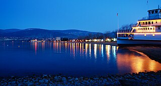
Penticton is a city in the Okanagan Valley of the Southern Interior of British Columbia, Canada, situated between Okanagan and Skaha lakes. In the 2016 Canadian Census, its population was 33,761, while its census agglomeration population was 43,432.

Okanagan Lake is a lake in the Okanagan Valley of British Columbia, Canada. The lake is 135 km (84 mi) long, between 4 and 5 km wide, and has a surface area of 348 km2.

A rail trail is a shared-use path on railway right of way. Rail trails are typically constructed after a railway has been abandoned and the track has been removed but may also share the right of way with active railways, light rail, or streetcars, or with disused track. As shared-use paths, rail trails are primarily for non-motorized traffic including pedestrians, bicycles, horseback riders, skaters, and cross-country skiers, although snowmobiles and ATVs may be allowed. The characteristics of abandoned railways—gentle grades, well-engineered rights of way and structures, and passage through historical areas—lend themselves to rail trails and account for their popularity. Many rail trails are long-distance trails, while some shorter rail trails are known as greenways or linear parks.

The Mount Lowe Railway was the third in a series of scenic mountain railroads in the United States created as a tourist attraction on Echo Mountain and Mount Lowe, north of Los Angeles, California. The railway, originally incorporated by Thaddeus S. C. Lowe as the Pasadena and Mt. Wilson Railroad Co., existed from 1893 until its official abandonment in 1938, and was the only scenic mountain, electric traction railroad ever built in the United States. Lowe's partner and engineer was David J. Macpherson, a civil engineer graduate of Cornell University. The Mount Lowe Railway was a fulfillment of 19th century Pasadenans' desire to have a scenic mountain railroad to the crest of the San Gabriel Mountains.
Princeton is a town municipality in the Similkameen region of southern British Columbia, Canada. The former mining and railway hub lies at the confluence of the Tulameen into the Similkameen River, just east of the Cascade Mountains. It is at the junction of BC Highway 3 and 5A.

Coquihalla Canyon Provincial Park, popularly called the Othello Tunnels is a provincial park located near Hope, British Columbia focused on the canyon of the Coquihalla River and a decommissioned railway grade, now a walking trail, leading eventually to Coquihalla Pass. Originally part of the Kettle Valley Railway, five tunnels and a series of bridges follow a relatively straight line through the gorge, which is lined with sheer, flat rock cliffs.

The OC&E Woods Line State Trail is a rail trail in Klamath and Lake counties in the U.S. state of Oregon. It is Oregon's longest state park. The trail follows the old OC&E and Weyerhaeuser railroads from Klamath Falls to Thompson Reservoir. Along its 105-mile (169 km) length it passes through the communities of Olene, Sprague River, Dairy, Beatty, and Bly.

Keremeos is a village in the Southern Interior of British Columbia, Canada. The name originated from the Similkameen dialect of the Okanagan language word "Keremeyeus" meaning "creek which cuts its way through the flats" referring to Keremeos Creek which flows down from the Upper Benchlands to the Similkameen River that flows past the village.

Myra-Bellevue Provincial Park is a provincial park in British Columbia, Canada, located in the Okanagan Highland east of Kelowna. It was established to protect the full elevational range of the North Okanagan Basin and North Okanagan Highlands ecosections.

Tulameen, originally known as Otter Flat, is a small community in British Columbia, Canada, about 26 kilometres northwest of the town of Princeton on the Crowsnest Highway, and about 185 kilometres northeast from the city of Vancouver, British Columbia. Located at the south end of Otter Lake and just north of the Tulameen River, it is on the lee side of the Canadian Cascades mountain range and enjoys a slightly semi-arid climate, sheltered from the heavy rains west of that range.

The Wallkill Valley Rail Trail is a 23.7-mile (38.1 km) rail trail and linear park that runs along the former Wallkill Valley Railroad rail corridor in Ulster County, New York, United States. It stretches from Gardiner through New Paltz, Rosendale and Ulster to the Kingston city line, just south of a demolished, concrete Conrail railroad bridge that was located on a team-track siding several blocks south of the also-demolished Kingston New York Central Railroad passenger station. The trail is separated from the Walden–Wallkill Rail Trail by two state prisons in Shawangunk, though there have been plans to bypass these facilities and to connect the Wallkill Valley Rail Trail with other regional rail-trails. The northern section of the trail forms part of the Empire State Trail.
British Columbia Highway 3, officially named the Crowsnest Highway, is an 841-kilometre (523 mi) highway that traverses southern British Columbia, Canada. It runs from the Trans-Canada Highway (Highway 1) at Hope to Crowsnest Pass at the Alberta border and forms the western portion of the interprovincial Crowsnest Highway that runs from Hope to Medicine Hat, Alberta. The highway is considered a Core Route of the National Highway System.
Brookmere is an unincorporated community adjacent to Brook Creek in the Nicola region of southern British Columbia, in Canada. The former railway town, on Coldwater Rd, is by road about 44 kilometres (27 mi) south of Merritt.
The Columbia and Western Railway (C&W) was a historic, and initially narrow gauge, railway in southern British Columbia.
Andrew McCulloch was born in Lanark County, Canada West and died in Penticton, British Columbia. was a civil engineer with the Canadian Pacific Railway (CPR).
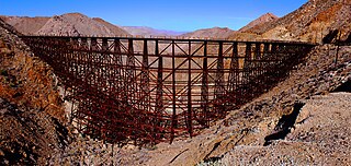
Goat Canyon Trestle is a wooden trestle in San Diego County, California. At a length of 597–750 feet (182–229 m), it is the world's largest all-wood trestle. Goat Canyon Trestle was built in 1933 as part of the San Diego and Arizona Eastern Railway, after one of the many tunnels through the Carrizo Gorge collapsed. The railway had been called the "impossible railroad" upon its 1919 completion. It ran through Baja California and eastern San Diego County before ending in Imperial Valley. The trestle was made of wood, rather than metal, due to temperature fluctuations in the Carrizo Gorge. By 2008, most rail traffic stopped using the trestle.

Kettle River Recreation Area is a 179 hectare provincial recreation area located inside a sharp S-bend of the Kettle River approximately 6 kilometres north of the community of Rock Creek, British Columbia. It is one of only two recreation areas in British Columbia, the other being Coquihalla Summit Recreation Area.

