Inklin River

Last updated

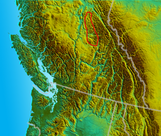
The Inklin River is a river in northern British Columbia, Canada. It flows northwest into the head of the Taku River, [1] which is formed by the convergence of the Inklin with the Nakina River, which flows southwest to meet it at the uninhabited locality of Inklin, which is located at the confluence. [2]

River Natural flowing watercourse

A river is a natural flowing watercourse, usually freshwater, flowing towards an ocean, sea, lake or another river. In some cases a river flows into the ground and becomes dry at the end of its course without reaching another body of water. Small rivers can be referred to using names such as stream, creek, brook, rivulet, and rill. There are no official definitions for the generic term river as applied to geographic features, although in some countries or communities a stream is defined by its size. Many names for small rivers are specific to geographic location; examples are "run" in some parts of the United States, "burn" in Scotland and northeast England, and "beck" in northern England. Sometimes a river is defined as being larger than a creek, but not always: the language is vague.

British Columbia Province of Canada

British Columbia is the westernmost province of Canada, located between the Pacific Ocean and the Rocky Mountains. With an estimated population of 5.016 million as of 2018, it is Canada's third-most populous province.

Canada Country in North America

Canada is a country in the northern part of North America. Its ten provinces and three territories extend from the Atlantic to the Pacific and northward into the Arctic Ocean, covering 9.98 million square kilometres, making it the world's second-largest country by total area. Canada's southern border with the United States is the world's longest bi-national land border. Its capital is Ottawa, and its three largest metropolitan areas are Toronto, Montreal, and Vancouver. As a whole, Canada is sparsely populated, the majority of its land area being dominated by forest and tundra. Consequently, its population is highly urbanized, with over 80 percent of its inhabitants concentrated in large and medium-sized cities, many near the southern border. Canada's climate varies widely across its vast area, ranging from arctic weather in the north, to hot summers in the southern regions, with four distinct seasons.

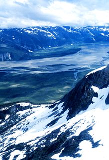
The river forms the southwestern boundary of the Taku Plateau, the northwesternmost sub-plateau of the Stikine Plateau. Along the river's southeast are the Boundary Ranges of the Coast Mountains.

The Taku Plateau is a sub-plateau of the Stikine Plateau in the far northwestern Interior of British Columbia, Canada. It lies to the south of the Teslin Plateau, part of the Yukon Plateau and to the southeast of the Yukon Plateau's other major sub-area within British Columbia, the Tagish Highland. Immediately northeast is the Kawdy Plateau and to the northwest of the Nahlin Plateau. The Inklin River forms the plateau's southwestern boundary with the northwestern extremities of the Tahltan Highland, beyond which are the Boundary Ranges. Very mountainous, its highest summit is Nahlin Mountain.

The Stikine Plateau is a plateau in northern British Columbia, Canada. It lies between the Boundary Ranges of the Coast Mountains on the west and southwest and the Cassiar Mountains along its northeast, and between the Skeena Mountains on its south and southeast and the Jennings and Nakina Rivers on the north.

Boundary Ranges

The Boundary Ranges, also known in the singular and as the Alaska Boundary Range, are the largest and most northerly subrange of the Coast Mountains. They begin at the Nass River, near the southern end of the Alaska Panhandle in the Canadian province of British Columbia and run to the Kelsall River, near the Chilkoot Pass, beyond which are the Alsek Ranges of the Saint Elias Mountains, and northwards into the Yukon Territory flanking the west side of the Yukon River drainage as far as Champagne Pass, north of which being the Yukon Ranges. To their east are the Skeena Mountains and Stikine Plateau of the Interior Mountains complex that lies northwest of the Interior Plateau; the immediately adjoining subregion of the Stikine Plateau is the Tahltan Highland. To their northeast is the Tagish Highland, which is a subregion of the Yukon Plateau. Both highlands are considered in some descriptions as included in the Coast Mountains. The Alexander Archipelago lies offshore and is entirely within Alaska.

See also

Related Research Articles

Taku River river in United States of America

The Taku River is a river running from British Columbia, Canada, to the northwestern coast of North America, at Juneau, Alaska. The river basin spreads across 27,500 square kilometres (10,600 sq mi). The Taku is a very productive salmon river and its drainage basin is primarily wilderness.

Tahltan Highland mountain in Canada

The Tahltan Highland is an upland area of plateau and relatively lower mountain ranges in British Columbia, Canada, lying east of the Boundary Ranges and south of the Inklin River. Its eastern boundary is formed by the Sheslay River and the Little Tuya River, while its southern boundary extends across the Stikine River and its Grand Canyon to include the Mount Edziza volcanic complex, and the Zagoddethchino massif.

The Lower Similkameen Indian Band or Lower Smelqmix, is a First Nations band government in the Canadian province of British Columbia. Their office is located in the village of Keremeos in the Similkameen region. They are a member of the Okanagan Nation Alliance.

Quesnel Highland mountain in Canada

The Quesnel Highland is a geographic area in the Central Interior of the Canadian province of British Columbia. As defined by BC government geographer in Landforms of British Columbia, an account and analysis of British Columbia geography that is often cited as authoritative, the Highland is a complex of upland hill and plateau areas forming and defined as being the buffer between the Cariboo Plateau and the Cariboo Mountains, as a sort of highland foothills along the eastern edge of the Interior Plateau running southeast from a certain point southeast of the city of Prince George to the Mahood Lake area at the southeast corner of the Cariboo. Beyond Mahood Lake lies another separately classified area dubbed by Holland the Shuswap Highland which spans similar terrain across the North Thompson and Shuswap Lake-Adams River drainage basins, forming a similar upland-area buffer between the Thompson Plateau and the Monashee Mountains. A third area, the Okanagan Highland, extends from the southern end of the Shuswap Highland in the area of Vernon and Enderby in the northern Okanagan region into Washington State, and also abuts the Monashee Mountains.

The Stone First Nation or Yunesit'in First Nation is a band government of the Yunesit'in subgroup of the Tsilhqot'in people, whose territory is the Chilcotin District in the western Central Interior region of the Canadian province of British Columbia. It is a member of the Tsilhqot'in Tribal Council. The people of the Stone First Nation are known as the Yunesit'in in the Chilcotin language.

The Sheslay River is a river in far northwestern British Columbia in the southeast portion of the basin of the Taku River. The river is 85 kilometres (53 mi) long from the confluence of the Hackett River to the junction of the Nahlin River, which is the commencement of the Inklin River, the main southeast fork of the Taku.

Robson Glacier glacier in Canada

The Robson Glacier is the primary source of the short Robson River, one of the uppermost tributaries of the Fraser River. Located on the British Columbia-Alberta Boundary and the Continental Divide to the east of Berg Lake in Mount Robson Provincial Park, it sits on the northeast flank of Mount Robson in Mount Robson Provincial Park, British Columbia in the Canadian Rockies. Its meltwater feeds unofficially named Robson Lake, whose outlet marks the start of the Robson River.

Bridge Creek is a creek in the South Cariboo region of the Interior of British Columbia, Canada. Its meandering course across the Cariboo Plateau is approximately 85 kilometres in length, beginning at Bridge Lake and running roughly westwards to the town of 100 Mile House and from there turning and running northeast to Canim Lake. Below Canim Lake the Canim River connects to Mahood Lake and the short Mahood River to the Clearwater River, which meets the North Thompson at the town of Clearwater.

Inklin Place in British Columbia, Canada

Inklin is a locality situated at the confluence of the Inklin and Nakina Rivers in far northwestern British Columbia, Canada, which is the commencement of the Taku River.

The Nakina River is a river in northwestern British Columbia, Canada, rising southeast of Atlin Lake and flowing generally southeast to its confluence with the Inklin River at the locality of Inklin, where the two rivers combine to form the Taku River.

The Torpy River is a tributary of the Fraser River, rising in the Northern Rockies and the McGregor Range, a subdivision of the McGregor Plateau, and forming the boundary between the Rockies and the McGregor Plateau.

Nahlin Plateau

The Nahlin Plateau is a plateau in northwestern British Columbia, Canada, located between the Sheslay River and Tuya River on the west and east and the Nahlin River and the Stikine River to the north and south. It is a subplateau of the Stikine Plateau; adjoining parts of the same larger plateau are the Taku Plateau to the northwest, the Tahltan Highland to the southwest and south, the Kawdy Plateau to the north, and the Spatsizi Plateau to the southeast. The Nahlin Plateau is the location of the Level Mountain Range and Heart Peaks, two small mountain ranges forming parts of large shield volcanoes.

The Tulsequah River, formerly the Talsekwe River, is a tributary of the Taku River in northwestern British Columbia, located south of the Atlin District and inland from Juneau, Alaska. The unincorporated settlement of Tulsequah is located at the confluence.

Whiting River river in United States of America

The Whiting River is a stream, about 50 miles (80 km) long, in the U.S. state of Alaska and the Canadian province of British Columbia. It enters the waters of Stephens Passage at the Borough of Juneau in the Alaska Panhandle between the mouths of the Taku and Stikine Rivers. The main tributary of the Whiting is the South Whiting. The river's basin is at the northern end of the Stikine Icecap The river crosses the international boundary at 58°11′00″N133°13′00″W. Its origin is in the Chechidla Range, and its terminus is at Gilbert Bay, which empties into Stephens Passage. In 1888, Lieutenant Commander C. M. Thomas of the U.S. Navy (USN) named the river for assistant surgeon Robert Whiting, USN, a member of his surveying party.

Tyoax Pass is a mountain pass in the Chilcotin Ranges of the Pacific Ranges, the southernmost main subdivision of the Coast Mountains of British Columbia, Canada. Located at the head of Tyaughton Creek, a north tributary of the Bridge River, it connects the basin of the Bridge River with that of Big Creek in the southern Chilcotin District, and is therefore at the boundary between the Spruce Lake Protected Area and Big Creek Provincial Park.

The Hackett River is a river in far northwestern British Columbia. It is a tributary of the Sheslay River, which is a feeder-stream of the Inklin River, the main southeast fork of the Taku. The locality of Sheslay is located at its confluence with the river of that name.

The Nahlin River is a river in far northwestern British Columbia, Canada, flowing northwest to meet the Sheslay River, forming there the commencement of the Inklin River, the main southeast fork of the Taku.

King Salmon Creek is a creek in the Atlin District of British Columbia, Canada. The creek begins at King Salmon Lake and flows generally eastward to join the Taku River. Southeast of that confluence is King Salmon Mountain.

References

Coordinates: 58°54′00″N133°08′00″W / 58.90000°N 133.13333°W / 58.90000; -133.13333

Geographic coordinate system Coordinate system

A geographic coordinate system is a coordinate system that enables every location on Earth to be specified by a set of numbers, letters or symbols. The coordinates are often chosen such that one of the numbers represents a vertical position and two or three of the numbers represent a horizontal position; alternatively, a geographic position may be expressed in a combined three-dimensional Cartesian vector. A common choice of coordinates is latitude, longitude and elevation. To specify a location on a plane requires a map projection.