
The Coast Mountains are a major mountain range in the Pacific Coast Ranges of western North America, extending from southwestern Yukon through the Alaska Panhandle and virtually all of the Coast of British Columbia south to the Fraser River. The mountain range's name derives from its proximity to the sea coast, and it is often referred to as the Coast Range. The range includes volcanic and non-volcanic mountains and the extensive ice fields of the Pacific and Boundary Ranges, and the northern end of the volcanic system known as the Cascade Volcanoes. The Coast Mountains are part of a larger mountain system called the Pacific Coast Ranges or the Pacific Mountain System, which includes the Cascade Range, the Insular Mountains, the Olympic Mountains, the Oregon Coast Range, the California Coast Ranges, the Saint Elias Mountains and the Chugach Mountains. The Coast Mountains are also part of the American Cordillera—a Spanish term for an extensive chain of mountain ranges—that consists of an almost continuous sequence of mountain ranges that form the western backbone of North America, Central America, South America and Antarctica.

The Pacific Coast Ranges are the series of mountain ranges that stretch along the West Coast of North America from Alaska south to Northern and Central Mexico. Although they are commonly thought to be the westernmost mountain range of the continental United States and Canada, the geologically distinct Insular Mountains of Vancouver Island lie farther west.

The Stikine River is a major river in northern British Columbia (BC), Canada and southeastern Alaska in the United States. It drains a large, remote upland area known as the Stikine Country east of the Coast Mountains. Flowing west and south for 610 kilometres (379 mi), it empties into various straits of the Inside Passage near Wrangell, Alaska. About 90 percent of the river's length and 95 percent of its drainage basin are in Canada. Considered one of the last truly wild large rivers in BC, the Stikine flows through a variety of landscapes including boreal forest, steep canyons and wide glacial valleys.

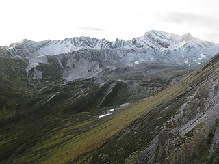
An ice field is a mass of interconnected valley glaciers on a mountain mass with protruding rock ridges or summits. They are often found in the colder climates and higher altitudes of the world where there is sufficient precipitation for them to form. The higher peaks of the underlying mountain rock that protrude through the icefields are known as nunataks. Ice fields are larger than alpine glaciers, but smaller than ice caps and ice sheets. The topography of ice fields is determined by the shape of the surrounding landforms, while ice caps have their own forms overriding underlying shapes.

The Pantheon Range is a subrange of the Pacific Ranges of the Coast Mountains in British Columbia. It is located between the edge of the Chilcotin Plateau at Tatla Lake on its northeast and the Klinaklini River on its west, with a southeastern boundary along Mosley Creek, a major tributary of the Homathko River. The range is 5,550 km2 (2,140 sq mi) in area and extremely rugged, with many sharp, glaciated peaks.

The British Columbia Coast, popularly referred to as the BC Coast or simply the Coast, is a geographic region of the Canadian province of British Columbia. As the entire western continental coastline of Canada along the Pacific Ocean is in the province, it is synonymous with being the West Coast of Canada.

The North American Cordillera, sometimes also called the Western Cordillera of North America, the Western Cordillera, or the Pacific Cordillera, is the North American portion of the American Cordillera, the mountain chain system along the Pacific coast of the Americas. The North American Cordillera covers an extensive area of mountain ranges, intermontane basins, and plateaus in Western and Northwestern Canada, Western United States, and Mexico, including much of the territory west of the Great Plains.
Chutine Peak is one of the highest mountains in the Boundary Ranges, a group of subranges of the northern Coast Mountains of British Columbia and Alaska. Chutine Peak lies just east of the Stikine Icecap, and to the north and west of the Stikine River, and south of the basin of the Whiting River. It is notable for its huge west face: the drop to Chutine Lake is 2,600 m (8,530 ft) in 3.5 km (2 mi). Due to its remoteness, however, it is rarely visited.
The Skeena Mountains, also known as the Skeenas, are a subrange of the Interior Mountains of northern British Columbia, Canada, essentially flanking the upper basin of the Skeena River. They lie just inland from the southern end of the Boundary Ranges of the Coast Mountains, and also of the northern end of the Kitimat Ranges. Their southern limit is described by the Bulkley River and the upper northwestern reaches of Babine and Takla Lakes, and on their northeast by the upper reaches of the Omineca River.
The Alsek Ranges are the southeasternmost subdivision of the Saint Elias Mountains of the Pacific Cordillera. They span the region between the Alsek River, Glacier Bay and the Kelsall River. Their western boundary is the Grand Pacific Glacier, beyond which is the Fairweather Range, another subdivision of the St. Elias Mountains. To their east is the northernmost section of the Boundary Ranges, the northernmost subdivision of the Coast Mountains and which are also known as the Alaska Boundary Range, and which run south to the Nass River and form, as their name indicates, the spine of the boundary between the American state of Alaska and the Canadian province of British Columbia.

The Stikine Icecap is a large icefield straddled on the Alaska–British Columbia boundary in the Alaska Panhandle region. It lies in the Boundary Ranges of the Coast Mountains. Within the United States, most of it is under the administration of the Tongass National Forest and is part of the Stikine-LeConte Wilderness within the national forest.

The Cassiar Mountains are the most northerly group of the Northern Interior Mountains in the Canadian province of British Columbia and also extend slightly into the southernmost Yukon Territory. They lie north and west of the Omineca Mountains, west of the northernmost Rockies and the Rocky Mountain Trench, north of the Hazelton Mountains and east of the Boundary Ranges. They form a section of the Continental Divide, that, in this region, separates water drainage between the Arctic and Pacific Oceans. Physiographically, they are a section of the larger Yukon-Tanana Uplands province, which in turn are part of the larger Intermontane Plateaus physiographic division.

The Interior Mountains or Northern Interior Mountains are the semi-official names for an expansive collection of mountain ranges that comprises much of the northern half of the Canadian province of British Columbia and a large area of southern Yukon.
The Sheslay River is a tributary of the Inklin River in northwest part of the province of British Columbia, Canada. It joins the Nahlin River to form the Inklin River, one of the main tributaries of the Taku River. The lower Sheslay River marks the boundary between the Taku Plateau and the Nahlin Plateau. Its mouth at the Nahlin River marks the junction of the Taku, Nahlin, and Kawdy Plateaus. All three of these are part of the larger Stikine Plateau region.

Mount Ratz is a mountain located just west of the Stikine River, about 5 km (3 mi) east of the British Columbia-Alaska border. It is the highest peak in the Stikine Icecap and of the Boundary Ranges which in turn form part of the Coast Mountains. It is an extremely high-prominence summit, with a difference in elevation with its "key col" at Hyland Ranch Pass of 2,430 m (7,972 ft). Thus making it one of Canada's Ultra peaks.

The Tahltan River is a tributary of the Stikine River in northwest part of the province of British Columbia, Canada. It flows generally east and southeast about 95 km (59 mi) to join the Stikine River at Tahltan, British Columbia. The lower Tahltan River marks the boundary between the Tahltan Highland and the Nahlin Plateau, both of which are part of the larger Stikine Plateau region.
Mount Nesselrode, also known as Boundary Peak 98, is a 2,474 m (8,117 ft) peak in the Boundary Ranges of the Coast Mountains, located on and in part defining the border between British Columbia, Canada, and Alaska, United States. About 40 miles (64 km) north of Juneau to the west of the lower Stikine River and in the heart of the Stikine Icecap in Juneau Icefield southwest of Atlin Lake, the summit, with a prominence of 924 m (3,031 ft), is also the corner point of Alaska's Haines Borough and Juneau Borough.
The Whiting River is a stream, about 50 miles (80 km) long, in the U.S. state of Alaska and the Canadian province of British Columbia. It enters the waters of Stephens Passage at the Borough of Juneau in the Alaska Panhandle between the mouths of the Taku and Stikine Rivers. The main tributary of the Whiting is the South Whiting. The river's basin is at the northern end of the Stikine Icecap The river crosses the international boundary at 58°11′00″N133°13′00″W. Its origin is in the Chechidla Range, and its terminus is at Gilbert Bay, which empties into Stephens Passage.
Stikine, meaning "great river" in the Tlingit language, may refer to:

