The Kelsall River is a river in the U.S. State of Alaska and the Canadian province of British Columbia. [1] It is a tributary of the Chilkat River, flowing into it in the Haines Borough of Alaska.

The Kelsall River is a river in the U.S. State of Alaska and the Canadian province of British Columbia. [1] It is a tributary of the Chilkat River, flowing into it in the Haines Borough of Alaska.

Mosquito Lake is a census-designated place (CDP) in Haines Borough, Alaska, United States. At the 2010 census the population was 309, up from 221 at the 2000 census.

Stanley Peak is a 3,155-metre (10,351 ft) mountain located in the Ball Range, at the northeastern section of Kootenay National Park, in the Canadian Rocky Mountains. The mountain was named in 1901 by its first climber, the English explorer Edward Whymper, after Frederick Stanley, 16th Earl of Derby, the sixth Governor-General of Canada. There are sources that date the naming in 1912 after Stanley H. Mitchell, Secretary-Treasurer of Alpine Club of Canada.

The Liard River of the North American boreal forest flows through Yukon, British Columbia and the Northwest Territories, Canada. Rising in the Saint Cyr Range of the Pelly Mountains in southeastern Yukon, it flows 1,115 km (693 mi) southeast through British Columbia, marking the northern end of the Rocky Mountains and then curving northeast back into Yukon and Northwest Territories, draining into the Mackenzie River at Fort Simpson, Northwest Territories. The river drains approximately 277,100 km2 (107,000 sq mi) of boreal forest and muskeg.
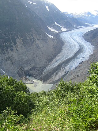
The Salmon River is a braided stream that flows through Hyder, Alaska, and empties into the Portland Canal. It is fed by meltwater from the Salmon Glacier, which is located within British Columbia approximately 13 miles north of its confluence into the Canal and is road-accessible from the town of Stewart, British Columbia. The river crosses the Canada–United States border at 56°02′00″N130°02′00″W.

The Boundary Ranges, also known in the singular and as the Alaska Boundary Range, are the largest and most northerly subrange of the Coast Mountains. They begin at the Nass River, near the southern end of the Alaska Panhandle in the Canadian province of British Columbia and run to the Kelsall River, near the Chilkoot Pass, beyond which are the Alsek Ranges of the Saint Elias Mountains, and northwards into the Yukon Territory flanking the west side of the Yukon River drainage as far as Champagne Pass, north of which being the Yukon Ranges. To their east are the Skeena Mountains and Stikine Plateau of the Interior Mountains complex that lies northwest of the Interior Plateau; the immediately adjoining subregion of the Stikine Plateau is the Tahltan Highland. To their northeast is the Tagish Highland, which is a subregion of the Yukon Plateau. Both highlands are considered in some descriptions as included in the Coast Mountains. The Alexander Archipelago lies offshore and is entirely within Alaska.

Buse Lake Protected Area, informally known as Buse Lake Provincial Park, is a provincial park in British Columbia, Canada, 23 km east-southeast of Kamloops near Monte Creek. It was created in 2000 as part of the outcome of the Kamloops Landuse and Resource Management Plan (KLRMP) and is 228 hectares in size.
Hyland River Provincial Park is a provincial park in British Columbia, Canada, located near the boundary with Yukon along the Alaska Highway just east of the community of Lower Post and north of the Liard River. Established in 1964, the park is 34 ha. in area.
Malaspina Provincial Park is a provincial park in British Columbia, Canada, located on the northeast side of the Malaspina Peninsula facing Desolation Sound in the northernmost area of that province's Sunshine Coast region.
Ruth Lake Provincial Park is a provincial park in British Columbia, Canada, located northeast of 100 Mile House.
Smelt Bay Provincial Park is a provincial park in British Columbia, Canada. It is located at the south end of Cortes Island, and has twenty-two camping sites. Eight are reservable and the rest are first-come, first-served. There is also an overflow parking lot directly next to the beach for any excess campers.

The Monarch Icefield is the northernmost of a series of large continental icecaps studding the heights of the Pacific Ranges of the Coast Mountains in southern British Columbia. Located southeast of the town of Bella Coola and west of the headwaters of the Atnarko River, a tributary of the Bella Coola River, it lies to the north of the Ha-Iltzuk Icefield, which is the largest icefield of the group and home to the Silverthrone volcano. The Monarch Icefield is very remote and is rarely visited by mountaineering parties.
Brandywine Creek, also formerly known as the Long John River after a local prospector and trapper, is a tributary of the Cheakamus River in the Pacific Ranges of the Coast Mountains in British Columbia, Canada, entering that stream via Daisy Lake, just below Brandywine Falls. The creek is about 14 km in length and originates on the south slope of Brandywine Mountain in Brandywine Meadows, at the southern end of the Powder Mountain Icefield and is the next basin immediately southwest of that of the Callaghan Valley, the site of the Nordic events facility for the 2010 Olympics. The creek's valley has been partially logged. An unnamed hot spring lies in its upper reaches, near Mount Fee.
The San Jose River is a river in the Cariboo region of the Central Interior of British Columbia, Canada. It rises in the area just northwest of 100 Mile House and includes in its watershed Lac La Hache, flowing northwestwards from there to its mouth at the head of Williams Lake, at the city of the same name. Williams Lake is drained by the Williams Lake River, effectively the continuation of the San Jose, and flows only a short distance before entering the Fraser River just west of the city.
The Whitesail Range is a subrange of the Tahtsa Ranges, located north of Whitesail River in northern British Columbia, Canada.
The McLeod River is a river in the Central Interior of British Columbia, Canada, flowing northeast into the north end of McLeod Lake.

The Coal River runs from southern Yukon, Canada, into northern British Columbia, Canada, where it flows into the Liard River at historic milepost 533 of the Alaska Highway. It was originally named Charles River in 1831, after John Charles of the Hudson's Bay Company. When Canadian explorer-geologist Richard George McConnell visited the river in 1887, he noted deposits of low grade lignite that had been brought down by the river.
The Shuswap Indian Reserve is a First Nations reserve in the Columbia Valley region of British Columbia, Canada, located on the left bank of the Columbia River, one mile (1.6 km) north of Invermere. The reserve is the home reserve of the Shuswap Indian Band, a band government of the Secwepemc (Shuswap) people and a member government of the Shuswap Nation Tribal Council and also of the Ktunaxa Kinbasket Tribal Council in alliance with nearby bands of the Ktunaxa people.
The Tsirku Glacier is a large icefield in the Saint Elias Mountains, spanning the border between British Columbia and Alaska, to the south of the Jarvis Glacier. It is the source of the Tsirku River, which flows northwest to become the second-largest tributary of the Chilkat River. GNIS gives its head at 59°17′00″N136°47′00″W and describes it as flowing across the Canada–US border one mile west of the head of the Tsirku River.
Taleomy Indian Reserve No. 3, officially Taleomy 3, is an Indian reserve under the governance of the Nuxalk Nation, located at the mouth of the Taleomey River on the east shore of South Bentinck Arm in the Central Coast region of British Columbia, Canada.
The Kokish River is a river on Northern Vancouver Island, flowing north into Beaver Cove. The community of Beaver Cove is near the river's mouth, as was the former logging camp of Englewood. The community of Kokish is also on Beaver Cove, but on its southeast shore away from the river-mouth.
59°31′53″N136°02′00″W / 59.53139°N 136.03333°W
| | This article about a location in the Haines Borough, Alaska is a stub. You can help Wikipedia by expanding it. |