
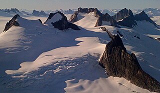
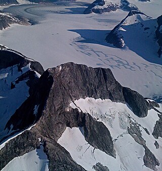
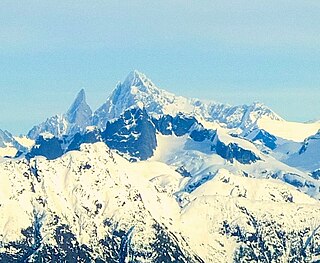
The Boundary Ranges, also known in the singular and as the Alaska Boundary Range, are the largest and most northerly subrange of the Coast Mountains. They begin at the Nass River, near the southern end of the Alaska Panhandle in the Canadian province of British Columbia and run to the Kelsall River, near the Chilkoot Pass, beyond which are the Alsek Ranges of the Saint Elias Mountains, and northwards into the Yukon Territory flanking the west side of the Yukon River drainage as far as Champagne Pass, north of which being the Yukon Ranges. To their east are the Skeena Mountains and Stikine Plateau of the Interior Mountains complex that lies northwest of the Interior Plateau; the immediately adjoining subregion of the Stikine Plateau is the Tahltan Highland. To their northeast is the Tagish Highland, which is a subregion of the Yukon Plateau. Both highlands are considered in some descriptions as included in the Coast Mountains. The Alexander Archipelago lies offshore and is entirely within Alaska.

Mount Steller is a peak at the far eastern end of the Chugach Mountains of Alaska, United States. It is notable for its isolated location among extensive icefields, and for its large rise above local terrain. For example, it rises 8,000 feet (2,400 m) above the Bering Glacier to the south in about 4 horizontal miles (6.4 km).

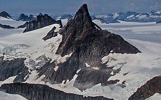
Horn Spire is a 6,700+ ft mountain summit located in the Boundary Ranges of the Coast Mountains, in the U.S. state of Alaska. The peak is situated between the Thiel Glacier and Battle Glacier at the northwest extent of the Juneau Icefield, 31 mi (50 km) north-northwest of Juneau, Alaska, and 12 mi (19 km) east of Lynn Canal, on land managed by Tongass National Forest. Horn Spire is the highest point of the Icefall Spires, and although modest in elevation, relief is significant since the north face of the mountain rises over 4,700 feet above the Thiel Glacier in less than one mile. The peak's descriptive name was submitted in 1965 by Maynard Miller, director of the Juneau Icefield Research Project, and officially adopted that same year by the U.S. Board on Geographic Names. The first ascent of the peak was made June 30, 1973, by Dick Benedict, Gerry Buckley, Craig Lingle, and Bruce Tickell.

The Snow Towers is a 7,100+ ft glaciated mountain summit located in the Boundary Ranges of the Coast Mountains, in the U.S. state of Alaska. The two peaks, 0.1 mi apart, are situated at the apex of the Taku and Herbert Glaciers near the western edge of the Juneau Icefield, 23 mi (37 km) north of Juneau, 1.8 mi (3 km) southwest of Snowpatch Crag, and 6.3 mi (10 km) northeast of Mount Ernest Gruening, on land managed by Tongass National Forest. The mountain was named by members of the Juneau Icefield Research Project in 1964, and was officially adopted in 1965 by the U.S. Board on Geographic Names. The first ascent was made in 1984 by Charles "Dick" Ellsworth and Bruce Tickell.

Taku Towers is a 6,653+ ft double summit mountain located in the Boundary Ranges of the Coast Mountains, in the U.S. state of Alaska. The two north and south peaks, 0.2 mi apart with 6,653+ and 6,605-ft elevations respectively, are situated in the Taku Range of the Juneau Icefield, 21 mi (34 km) north of Juneau, Alaska, and 5.5 mi (9 km) east-southeast of The Snow Towers, on land managed by Tongass National Forest. The Taku Range is a north-south trending ridge on the edge of the Taku Glacier. The mountain's name was in local use when first published in 1960 by the U.S. Geological Survey. Several landforms in the vicinity bear this Taku name, which all ultimately derive from the Taku people. The first ascent was made in 1949 by Forbes, Merritt, and Schoeblen via the west ridge. Daniel Reid and party made the first ascent of the difficult east face of South Taku Tower in 1973.
Emperor Peak is a 6,805 ft (2,070 m) glaciated mountain summit located in the Boundary Ranges of the Coast Mountains, in the U.S. state of Alaska. Emperor Peak is situated in the Taku Range of the Juneau Icefield, 20 mi (32 km) north of Juneau, and 1.2 mi (2 km) south-southwest of Taku Towers, on land managed by Tongass National Forest. The Taku Range is a north–south trending ridge on the edge of the Taku Glacier. This mountain was named in 1964 by members of the Juneau Icefield Research Project, and officially adopted in 1965 by the U.S. Geological Survey.

Princess Peak is a 6,585 ft (2,010 m) glaciated mountain summit located in the Boundary Ranges of the Coast Mountains, in the U.S. state of Alaska. Emperor Peak is situated in the Taku Range of the Juneau Icefield, 18 mi (29 km) north of Juneau, and 1.6 mi (3 km) south of Emperor Peak, on land managed by Tongass National Forest. The Taku Range is a north–south trending ridge on the edge of the Taku Glacier. This mountain was named in 1964 by members of the Juneau Icefield Research Project, and officially adopted in 1965 by the U.S. Board on Geographic Names.

Cathedral Peak is a 6,500+ ft mountain summit located in the Boundary Ranges of the Coast Mountains, in the U.S. state of Alaska. The peak is situated in the Taku Range of the Juneau Icefield, 22 mi (35 km) north of Juneau, and 1 mi (2 km) north of Taku Towers, on land managed by Tongass National Forest. The Taku Range is a north-south trending ridge on the edge of the Taku Glacier. The mountain was named in 1964 by members of the Juneau Icefield Research Project, and officially adopted in 1965 by the U.S. Board on Geographic Names.
Rhino Peak is a 6,400+ ft mountain summit located in the Boundary Ranges of the Coast Mountains, in the U.S. state of Alaska. The peak is situated on the Juneau Icefield, 18 mi (29 km) north of Juneau, and 2 mi (3 km) west of Princess Peak, on land managed by Tongass National Forest. Rhino Peak is set at the head of Mendenhall Glacier. This peak's descriptive name was published in 1960 by the U.S. Geological Survey.

Guardian Mountain is a 5,060 ft (1,540 m) glaciated mountain summit located in the Boundary Ranges of the Coast Mountains, in the U.S. state of Alaska. The peak is situated in the southern portion of the Juneau Icefield, 15 mi (24 km) northeast of Juneau, and 2.4 mi (4 km) southwest of Slanting Peak which is its nearest higher neighbor. Guardian Mountain is a nunatak surrounded by the Norris Glacier, on land managed by Tongass National Forest. This peak's local name was published in 1960 by the U.S. Geological Survey.

Nugget Mountain is a 5,587 ft (1,700 m) glaciated mountain summit located in the Boundary Ranges of the Coast Mountains, in the U.S. state of Alaska.
Slanting Peak is a 5,200+ ft glaciated mountain summit located in the Boundary Ranges of the Coast Mountains, in the U.S. state of Alaska. The peak is situated in the southern portion of the Juneau Icefield, 18 mi (29 km) northeast of Juneau, and 2.4 mi (4 km) northeast of Guardian Mountain, which is its nearest neighbor. Slanting Peak is surrounded by the North Branch Norris Glacier to its west, and Taku Glacier on the east, and set on land managed by Tongass National Forest. This peak's descriptive name was published in 1960 by the U.S. Geological Survey.

Snowpatch Crag is a 6,345 ft (1,930 m) elevation glaciated mountain summit located in the Boundary Ranges of the Coast Mountains, in the U.S. state of Alaska. Snowpatch Crag is a nunatak surrounded by the Taku Glacier, and is situated near the west side of the Juneau Icefield, 25 mi (40 km) north of Juneau, and 1.8 mi (3 km) northeast of The Snow Towers, on land managed by Tongass National Forest. The mountain was named by members of the Juneau Icefield Research Project in 1964, and was officially adopted in 1965 by the U.S. Board on Geographic Names. Variant names for this geographic feature are "Snowpatch Peak" and "Snowpatch Craig."

Nugget Towers is a mountain ridge with a series of peaks, two primarily, the highest of which is 5,378-ft elevation, and located on the southern periphery of the Juneau Icefield, in the Boundary Ranges of southeast Alaska. These peaks are situated east of Mendenhall Glacier, 10 mi (16 km) north of Juneau, and 1.9 mi (3 km) northeast of Bullard Mountain, on land managed by Tongass National Forest. Stroller White Mountain lies 4.5 mi (7 km) west-northwest on the opposite side of the glacier, and Heintzleman Ridge lies 3 mi (5 km) to the south. Although modest in elevation, relief is significant since the mountain rises 3,500 feet above Nugget Creek's upper basin in less than one mile. Precipitation runoff from the mountain drains into Mendenhall Lake via Nugget Creek and Nugget Falls. This geographic feature's local name was reported in 1965 by U.S. Geological Survey.

Nelles Peak is a remote 2,531-metre (8,304-foot) mountain summit located in the Coast Mountains of British Columbia, Canada. It is situated at the northeastern periphery of the Juneau Icefield, 5.0 km (3.1 mi) inside the BC-Alaska boundary, on the west side of Tulsequah Lake. Its nearest higher peak is Devils Paw, 9.0 km (5.6 mi) to the southeast. Nelles Peak is the second-highest summit of the icefield, after Devils Paw. The mountain was named in 1924 to honor Douglas H. Nelles (1881–1960), a Canadian engineer who participated with the International Boundary Survey party of 1907. The mountain's name was officially adopted in 1947 when approved by the Geographical Names Board of Canada.

Mount Queena is a 7,620+ ft elevation mountain summit located in the Boundary Ranges of the Coast Mountains, in the U.S. state of Alaska. This unofficially named peak is situated on the Juneau Icefield, 39 mi (63 km) north of Juneau, 2.7 mi (4 km) west of the Canada–United States border, and 5 mi (8 km) northeast of Mount Blachnitzky, on land managed by Tongass National Forest. Although modest in elevation, relief is significant since the east aspect of the mountain rises over 3,200 feet above the Gilkey Glacier in less than one mile. The nearest higher neighbor is Mount Ogilvie, 2.5 mi (4 km) to the east.
Mount Burkett is a 9,730-foot-elevation (2,966-meter) mountain summit in Alaska, United States.

Glacier King is a 6,500-foot-elevation (1,981-meter) mountain summit in Alaska, United States.
Mount Ogilvie is a 7,867-foot-elevation (2,398-meter) mountain summit located on, and in part defining, the international border between Alaska, United States, and British Columbia, Canada.

Observation Peak is a 4,931-foot (1,503 m) mountain summit located in the Boundary Ranges of the Coast Mountains, in the U.S. state of Alaska. The peak is situated 4.5 miles (7.2 km) northeast of Juneau along the southern periphery of the Juneau Icefield, on land managed by Tongass National Forest. Precipitation runoff and glacial meltwater from the mountain drains to Gastineau Channel via Lemon and Salmon creeks, whereas the southeast slope drains to Taku Inlet via Carlson Creek. Although modest in elevation, relief is significant as the summit rises over 3,700 feet (1,128 m) above Salmon Creek Reservoir in 1.6 miles (2.6 km). This peak's local name was published in 1962 by the U.S. Geological Survey and the toponym has been officially adopted by the U.S. Board on Geographic Names.


