
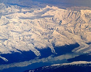
Mount Logan is the highest mountain in Canada and the second-highest peak in North America after Denali. The mountain was named after Sir William Edmond Logan, a Canadian geologist and founder of the Geological Survey of Canada (GSC). Mount Logan is located within Kluane National Park Reserve in southwestern Yukon, less than 40 km (25 mi) north of the Yukon–Alaska border. Mount Logan is the source of the Hubbard and Logan glaciers. Although many shield volcanoes are much larger in size and mass, Mount Logan is believed to have the largest base circumference of any non-volcanic mountain on Earth, including a massif with eleven peaks over 5,000 m (16,000 ft).

Mount Saint Elias, the second-highest mountain in both Canada and the United States, stands on the Yukon and Alaska border about 26 miles (42 km) southwest of Mount Logan, the highest mountain in Canada. The Canadian side of Mount Saint Elias forms part of Kluane National Park and Reserve, while the U.S. side of the mountain is located within Wrangell-St. Elias National Park and Preserve.
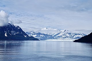
The Saint Elias Mountains are a subgroup of the Pacific Coast Ranges, located in southeastern Alaska in the United States, Southwestern Yukon and the very far northwestern part of British Columbia in Canada. The range spans Wrangell-St. Elias National Park and Preserve in the United States and Kluane National Park and Reserve in Canada and includes all of Glacier Bay National Park in Alaska. In Alaska, the range includes parts of the city/borough of Yakutat and the Hoonah-Angoon and Valdez-Cordova census areas.

Mount Fairweather is 20 km (12 mi) east of the Pacific Ocean on the Canada–United States border between Alaska and western British Columbia and has an elevation of 4,653 metres (15,266 ft). Most of the mountain lies within Glacier Bay National Park and Preserve in the City and Borough of Yakutat, Alaska, though the summit borders Tatshenshini-Alsek Provincial Park, British Columbia. Tsalxaan is officially gazetted as Fairweather Mountain in Canada but referred to as Mount Fairweather, and is the highest mountain in the Canadian province of British Columbia. It is also designated as Boundary Peak 164 or as US/Canada Boundary Point #164.
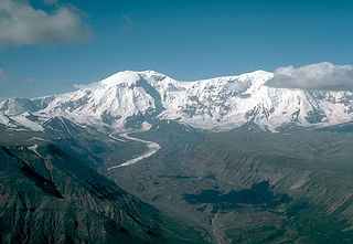
Mount Hubbard is one of the major mountains of the Saint Elias Range. It is located on the Alaska/Yukon border; the Canadian side is within Kluane National Park and Reserve, and the American side is part of Wrangell–St. Elias National Park. The mountain was named in 1890 by U.S. Geological Survey geologist Israel Russell after Gardiner Greene Hubbard, first president of the National Geographic Society, which had co-sponsored Russell's expedition.

Mount Blackburn is the highest peak in the Wrangell Mountains of Alaska in the United States. It is the fifth-highest peak in the United States and the twelfth-highest peak in North America. The mountain is an old, eroded shield volcano, the second-highest volcano in the U.S. behind Mount Bona and the fifth-highest in North America. It was named in 1885 by Lt. Henry T. Allen of the U.S. Army after Joseph Clay Stiles Blackburn, a U.S. senator from Kentucky. It is located in the heart of Wrangell – St. Elias National Park, the largest national park in the country.

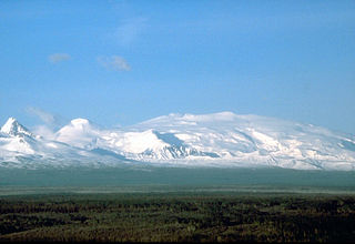
Mount Sanford is a shield volcano in the Wrangell Volcanic Field, in eastern Alaska near the Copper River. It is the sixth highest mountain in the United States and the third highest volcano behind Mount Bona and Mount Blackburn. The south face of the volcano, at the head of the Sanford Glacier, rises 8,000 feet (2,400 m) in 1 mile (1,600 m) resulting in one of the steepest gradients in North America.
Mount Wrangell, in Ahtna K’ełt’aeni or K’ełedi when erupting, is a massive shield volcano located in Wrangell-St. Elias National Park and Preserve in southeastern Alaska, United States. The shield rises over 12,000 feet (3,700 m) above the Copper River to its southwest. Its volume is over 220 cubic miles (920 km3), making it more than twice as massive as Mount Shasta in California, the largest stratovolcano by volume in the Cascades. It is part of the Wrangell Volcanic Field, which extends for more than 250 kilometers (160 mi) across Southcentral Alaska into the Yukon Territory in Canada, and has an eruptive history spanning the time from Pleistocene to Holocene.

Mount Bona is one of the major mountains of the Saint Elias Mountains in eastern Alaska, and is the fifth-highest independent peak in the United States. It is either the tenth- or eleventh-highest peak in North America. Mount Bona and its adjacent neighbor Mount Churchill are both large ice-covered stratovolcanoes. Bona has the distinction of being the highest volcano in the United States and the fourth-highest in North America, outranked only by the three highest Mexican volcanoes, Pico de Orizaba, Popocatépetl, and Iztaccíhuatl. Its summit is a small stratovolcano on top of a high platform of sedimentary rocks.
Mount Marcus Baker is the highest peak of the Chugach Mountains of Alaska. It is located approximately 75 miles (121 km) east of Anchorage. This peak is very prominent because of its proximity to tidewater and is only 12 miles (19 km) north of the calving face of Harvard Glacier. Mount Marcus Baker is ranked 67th in the world when measured by topographic prominence.

Mount Bear is a high, glaciated peak in the Saint Elias Mountains of Alaska. It lies within Wrangell-Saint Elias National Park, about 4 miles (6.4 km) west of the Yukon border. The Barnard Glacier flows from its southwest slopes, while the Klutlan Glacier lies to the north. Its principal claim to fame is that it is a fourteener, and in fact one of the highest 20 peaks in the United States.

Mount Miller is an isolated peak of the Saint Elias Mountains in Alaska, United States. It is notable for its position among spectacular icefields, its distance from any inhabited place, and its large rise above local terrain. It is over 65 miles (105 km) from McCarthy, the nearest habitation, and over 105 miles (169 km) away from Yakutat, the nearest significant town. Exemplifying the size of the mountain, the south flank rises 9,000 feet (2,700 m) above the Duktoth River valley to the south in approximately 9 horizontal miles (14 km).

Mount Cook is a high peak on the Yukon Territory-Alaska border, in the Saint Elias Mountains of North America. It is approximately 15 miles southwest of Mount Vancouver and 35 miles east-southeast of Mount Saint Elias. It forms one of the corners of the jagged border, which is defined to run in straight lines between the major peaks. The same border also separates Kluane National Park in the Yukon Territory from Wrangell-St. Elias National Park and Preserve in Alaska.
Mount Natazhat is a high peak of the Saint Elias Mountains, of Alaska, United States, just west of the border with the Yukon Territory of Canada. It lies on the northern edge of the range, south of the White River and north of the Klutlan Glacier. Mount Natazhat is a little-noticed peak; however it is a very large peak in terms of rise above local terrain. It rises 9,000 feet (2,743 m) in less than 7 miles (11.3 km) above the lowlands to the north, and 7,500 feet (2,286 m) in about 4 miles (6.4 km) above the Klutlan Glacier to the south.

Mount Drum is a stratovolcano in the Wrangell Mountains of east-central Alaska in the United States. It is located at the extreme western end of the Wrangells, 18 miles (29 km) west-southwest of Mount Sanford and the same distance west-northwest of Mount Wrangell. It lies just inside the western boundary of Wrangell-Saint Elias National Park and Preserve and is 25 miles (40 km) east of the Copper River.
Mount Jarvis is an eroded shield volcano in the Wrangell Mountains of eastern Alaska. It is located in Wrangell-Saint Elias National Park about 10 miles (16 km) east of the summit of Mount Wrangell. The mountain sits at the northeastern edge of the massive ice-covered shield of Wrangell, rising nearly 5,000 feet (1,500 m) above it in a spectacular series of cliffs and icefalls.
This article comprises three sortable tables of major mountain peaks of Canada.

Mount Seattle is a 10,350-foot (3,150 m) peak in the Saint Elias Mountains of Alaska in the United States. It was named for the city of Seattle, home of the "camp hands" of a 19th-century National Geographic Society–United States Geological Survey scientific expedition to the Hubbard Glacier and Mount Saint Elias. It is called the "most prominent Alaskan coastal peak" and blocks sight of larger inland peaks, even Mount Logan nearly twice its height.
Mount Decoeli is a 2,332-metre (7,651-foot) pyramidal peak located in the Kluane Ranges of the Saint Elias Mountains in Yukon, Canada. The mountain is situated 23 km (14 mi) northwest of Haines Junction, 21.4 km (13 mi) east of Mount Cairnes, and can be seen from the Alaska Highway midway between the two. Its nearest higher peak is Mount Archibald, 6 km (3.7 mi) to the south. The mountain's name was officially adopted August 12, 1980, by the Geographical Names Board of Canada. James J. McArthur was a Canadian surveyor and mountaineer who undertook extensive surveying in the Yukon during his later years. In 1908 he made the first ascent of Williams Peak accompanied by Edmond Treau de Coeli (1873–1963). Decoeli is pronounced deh-coh-lie. To the Southern Tutchone people, the mountain is known as Nàday Gän, meaning Dried Lynx Mountain.

Mount Malaspina is a 3,776-metre (12,388-foot) mountain summit in Yukon, Canada.


