
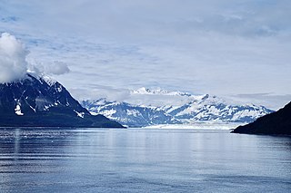
Mount Logan is the highest mountain in Canada and the second-highest peak in North America after Denali. The mountain was named after Sir William Edmond Logan, a Canadian geologist and founder of the Geological Survey of Canada (GSC). Mount Logan is located within Kluane National Park Reserve in southwestern Yukon, less than 40 km (25 mi) north of the Yukon–Alaska border. Mount Logan is the source of the Hubbard and Logan glaciers. Although many shield volcanoes are much larger in size and mass, Mount Logan is believed to have the largest base circumference of any non-volcanic mountain on Earth, including a massif with eleven peaks over 5,000 m (16,000 ft). Mount Logan is the 6th most topographically prominent peak on Earth.

Mount Saint Elias, the second-highest mountain in both Canada and the United States, stands on the Yukon and Alaska border about 26 miles (42 km) southwest of Mount Logan, the highest mountain in Canada. The Canadian side of Mount Saint Elias forms part of Kluane National Park and Reserve, while the U.S. side of the mountain is located within Wrangell-St. Elias National Park and Preserve.
Mount Wood is the seventh-highest mountain in Canada and is located in Kluane National Park and Reserve. In 1900 it was named by the surveyor James J. McArthur (1856–1925) after Zachary Taylor Wood (d.1915), a North-West Mounted Police inspector in Dawson during the Klondike Gold Rush. He was later the commissioner of the NWMP.

Mount Vancouver is the 15th highest mountain in North America. Its southern side lies in Glacier Bay National Park and Preserve at the top of the Alaska panhandle, while its northern side is in Kluane National Park and Reserve in the southwestern corner of Yukon, Canada. Mount Vancouver has three summits: north, middle, and south, with the middle summit being the lowest. The south summit, Good Neighbor Peak at 4,785 m (15,699 ft), straddles the international border while the north summit is slightly higher at 4,812 m (15,787 ft).
Mount Hubbard is one of the major mountains of the Saint Elias Range. It is located on the Alaska/Yukon border; the Canadian side is within Kluane National Park and Reserve, and the American side is part of Wrangell–St. Elias National Park. The mountain was named in 1890 by U.S. Geological Survey geologist Israel Russell after Gardiner Greene Hubbard, first president of the National Geographic Society, which had co-sponsored Russell's expedition.

Mount Kennedy is a peak in the Saint Elias Mountains within Kluane National Park, in Yukon, Canada. Its 4250-m to 4300-m (14000-foot) summit lies within 10 km of the Alaska Panhandle. Dusty Glacier lies against it to the north.

James Morrow Walsh was a North-West Mounted Police (NWMP) officer and the first commissioner of Yukon.

Mount Augusta, also designated Boundary Peak 183, is a high peak in the US state of Alaska and the Canadian territory of Yukon. It lies about 25 km (16 mi) south of Mount Logan and 25 km east of Mount Saint Elias, respectively the first and second highest mountains in Canada. Mount Augusta forms the eastern end of the long ridge of which Mount Saint Elias is the center and highest point.

Mount Bear is a high, glaciated peak in the Saint Elias Mountains of Alaska. It lies within Wrangell-Saint Elias National Park, about 4 miles (6.4 km) west of the Yukon border. The Barnard Glacier flows from its southwest slopes, while the Klutlan Glacier lies to the north. Its principal claim to fame is that it is a fourteener, and in fact one of the highest 20 peaks in the United States.
Mount Alverstone or Boundary Peak 180, is a high peak in the Saint Elias Mountains, on the border between Alaska and Yukon. It shares a large massif with the higher Mount Hubbard to the south and the slightly lower Mount Kennedy to the east. The summit of Mount Alverstone marks a sharp turn in the Alaska/Canada border; the border goes south from this point toward the Alaska panhandle and west toward Mount Saint Elias.

Mount Cook is a high peak on the Yukon Territory-Alaska border, in the Saint Elias Mountains of North America. It is approximately 15 mi (24 km) southwest of Mount Vancouver and 35 mi (56 km) miles east-southeast of Mount Saint Elias. It forms one of the corners of the jagged border, which is defined to run in straight lines between the major peaks. The same border also separates Kluane National Park in the Yukon Territory from Wrangell-St. Elias National Park and Preserve in Alaska.
Mount Natazhat is a high peak of the Saint Elias Mountains, of Alaska, United States, just west of the border with the Yukon Territory of Canada. It lies on the northern edge of the range, south of the White River and north of the Klutlan Glacier. Mount Natazhat is a little-noticed peak; however it is a very large peak in terms of rise above local terrain. It rises 9,000 feet (2,743 m) in less than 7 miles (11.3 km) above the lowlands to the north, and 7,500 feet (2,286 m) in about 4 miles (6.4 km) above the Klutlan Glacier to the south.
McArthur Peak is a peak in the Saint Elias Mountains of Yukon, Canada. The peak, 13th highest in Canada, sits 11 km NE of Mount Logan, the highest mountain in Canada. A secondary peak two kilometres to the east is known as McArthur East. The peak was named for James Joseph McArthur, a Dominion Land Surveyor who also made the first ascent of a Canadian peak over 10,000 ft — Mount Stephen in 1887.
This article comprises three sortable tables of major mountain peaks of Canada.
Mount Strickland is a mountain in the Saint Elias Mountains of Yukon, Canada. The Mountain takes its name from Charles W. Strickland (1935–1983), a refuge Manager of the Kodiak National Wildlife Refuge.

Mount Prindle is a granitic mountain in the Yukon–Tanana Uplands, and is located approximately 45 miles (72 km) north-northeast of Fairbanks, Alaska. The plutons that form the core of the Mount Prindle massif are Late Cretaceous or early Tertiary age. These plutons intruded older metamorphic rocks. Mount Prindle exhibits classic glacial landforms, unlike most of the surrounding Yukon–Tanana Uplands. It is in the Circle Mining District and many of the surrounding creeks have been or are being mined for placer gold. The area has also been prospected for tin and rare earth minerals. Mine roads and hiking trails provide access to the mountain. A 900 feet (270 m) granite wall on an eastern spur of the massif is an attraction for rock climbers.
The Centennial Range is a sub-range of the Saint Elias Mountains. It is located inside Kluane National Park and Reserve in the far west of Yukon Territory in Canada. It consists of fourteen major peaks, and was named for Canada's Centennial in 1967. Its peaks bear the names of Canada's provinces and territories, with the exception of Nunavut, which was not a territory at the time. The tallest point is Centennial Peak. Nine of the peaks were climbed as part of the Yukon Alpine Centennial Expedition, part of the 1967 celebrations.
Mount Macaulay is a mountain peak in Canada, located in Kluane National Park and Reserve in Yukon.
Mount Atherton is a mountain in Canada. It is located in the province of Yukon, in the western part of the country, 4,100 km west of the capital Ottawa. The peak of Mount Atherton is 1,892 metres above sea level, or 625 metres above the surrounding terrain. The width at the base is 12.2 km. It was named after Charles Thomas Atherton, who succeeded Deacon Phelps as a member of the Yukon Territorial Council, representing Whitehorse from 1934 to 1937.
