Destruction Bay

Last updated

Destruction Bay
Destructionwelcome.jpg
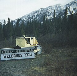
Welcome sign made on an old bulldozer
Canada location map 2.svg
Red pog.svg
Destruction Bay
Coordinates: 61°15′15″N138°48′24″W / 61.25417°N 138.80667°W / 61.25417; -138.80667
CountryCanada
Territory Yukon
Area
[1]
  Land13.57 km2 (5.24 sq mi)
Population
 (2016) [1]
  Total
55
  Density4.1/km2 (11/sq mi)
Time zone UTC−07:00 (MST)

Destruction Bay is a small community on the Alaska Highway (historical mile 1083) in Canada's Yukon on Kluane Lake.

Contents

Populated mostly by non-aboriginal residents, community residents provide Yukon government services to residents in the area (school, highway maintenance), including nearby Burwash Landing and some tourism-related businesses along the Alaska Highway. The name is derived from the wind blowing down structures erected by the military during highway construction in 1942–43.

The community has a school with three classrooms serving kindergarten through grade eight.

Demographics

Federal census population history of Destruction Bay
YearPop.±%
198149    
198648−2.0%
1991 32−33.3%
1996 34+6.2%
2001 43+26.5%
2006 55+27.9%
2011 35−36.4%
2016 55+57.1%
2021 40−27.3%
Source: Statistics Canada
[2] [3] [4] [5] [6] [7] [8] [9]

In the 2021 Census of Population conducted by Statistics Canada, Destruction Bay had a population of 40 living in 16 of its 32 total private dwellings, a change of

History

In 1942, a camp was set up to be used by crews working to build the Alaska Highway. [10] It was used for housing of workers, as well as a stopping place for truckers to rest, refuel, and service their equipment. [10] Not long after it was built, a severe windstorm destroyed many of the buildings in the camp, leading to the name Destruction Bay. [10] [11]

References

  1. 1 2 "Census Profile". 2016 Census . Statistics Canada. Retrieved January 21, 2018.
  2. "1986 Census: Population - Census Divisions and Census Subdivisions" (PDF). Statistics Canada. September 1987. Retrieved January 30, 2022.
  3. "91 Census: Census Divisions and Census Subdivisions - Population and Dwelling Counts" (PDF). Statistics Canada. April 1992. Retrieved January 30, 2022.
  4. "96 Census: A National Overview - Population and Dwelling Counts" (PDF). Statistics Canada. April 1997. Retrieved January 30, 2022.
  5. "Population and Dwelling Counts, for Canada, Provinces and Territories, and Census Subdivisions (Municipalities), 2001 and 1996 Censuses - 100% Data (Yukon Territory)". Statistics Canada. August 15, 2012. Retrieved January 30, 2022.
  6. "Population and dwelling counts, for Canada, provinces and territories, and census subdivisions (municipalities), 2006 and 2001 censuses - 100% data (Yukon Territory)". Statistics Canada. August 20, 2021. Retrieved January 30, 2022.
  7. "Population and dwelling counts, for Canada, provinces and territories, and census subdivisions (municipalities), 2011 and 2006 censuses (Yukon)". Statistics Canada. July 25, 2021. Retrieved January 30, 2022.
  8. "Population and dwelling counts, for Canada, provinces and territories, and census subdivisions (municipalities), 2016 and 2011 censuses – 100% data (Yukon)". Statistics Canada. February 8, 2017. Retrieved January 30, 2022.
  9. 1 2 "Population and dwelling counts: Canada, provinces and territories, and census subdivisions (municipalities), Yukon". Statistics Canada. February 9, 2022. Retrieved February 18, 2022.
  10. 1 2 3 "Destruction Bay". www.thecanadianencyclopedia.ca. Retrieved July 12, 2024.
  11. "Destruction Bay | Travel Yukon - Yukon, Canada | Official Tourism Website for the Yukon Territory". www.travelyukon.com. Retrieved July 12, 2024.