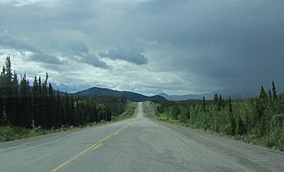
Whitehorse is the capital of the Yukon, and the largest city in Northern Canada. It was incorporated in 1950 and is located at kilometre 1426 on the Alaska Highway in southern Yukon. Whitehorse's downtown and Riverdale areas occupy both shores of the Yukon River, which rises in British Columbia and meets the Bering Sea in Alaska. The city was named after the White Horse Rapids for their resemblance to the mane of a white horse, near Miles Canyon, before the river was dammed.

Dawson City, officially the City of Dawson, is a town in the Canadian territory of Yukon. It is inseparably linked to the Klondike Gold Rush (1896–1899). Its population was 1,577 as of the 2021 census, making it the second-largest municipality in Yukon.

Haines Junction is a village in Yukon, Canada. It is at Kilometre 1,632 of the Alaska Highway at its junction with the Haines Highway, hence the name of the community. According to the 2021 census, the population was 688. However, the Yukon Bureau of Statistics lists the population count for 2022 as 1,018.

The Municipality of the District of Lunenburg, is a district municipality in Lunenburg County, Nova Scotia, Canada. Statistics Canada classifies the district municipality as a municipal district.

North Cowichan is a district municipality established in 1873 on Vancouver Island, in British Columbia, Canada. The municipality is part of the Cowichan Valley Regional District. North Cowichan is noted for a landscape including forests, beaches, rivers, and lakes. The municipality encompasses the communities of Chemainus; Westholme; Crofton; Maple Bay; and "the South End". The latter is an informal name for a built-up area which is essentially a suburb of the City of Duncan, a separate municipality.

Kimberley is a city in southeast British Columbia, Canada along Highway 95A between the Purcell and Rocky Mountains. Kimberley was named in 1896 after the Kimberley mine in South Africa. From 1917 to 2001, it was the home to the world's largest lead-zinc mine, the Sullivan Mine. Now it is mainly a tourist destination and home to the Kimberley Alpine Resort, a ski area and Kimberley's Underground Mining Railway that features a 750-foot-long (230 m) underground mining interpretive centre complete with operational 3 ft narrow-gauge railway equipment. Recreational pursuits include world-class skiing, snowboarding, snowmobiling, fishing, whitewater rafting, kayaking, biking, hiking and golfing on championship golf courses. The city has the largest urban park in Canada. At 1,977 acres (800 ha), the Kimberley Nature Park is the largest incorporated park in Canada.

The Cowichan Valley Regional District is a regional district in the Canadian province of British Columbia that is on the southern part of Vancouver Island, bordered by the Nanaimo and Alberni-Clayoquot Regional Districts to the north and northwest, and by the Capital Regional District to the south and east. As of the 2021 Census, the Regional District had a population of 89,013. The regional district offices are in Duncan.

Watson Lake is a town in Yukon, Canada, located at mile 635 on the Alaska Highway close to the British Columbia border. It had a population of 1,133 in 2021. The town is named for Frank Watson, an American-born trapper and prospector, who settled in the area at the end of the 19th century.

Beaumont is a city adjacent to Leduc County within the Edmonton Metropolitan Region of Alberta, Canada. It is at the intersection of Highway 625 and Highway 814, adjacent to the City of Edmonton and 6.0 kilometres (3.7 mi) northeast of the City of Leduc. The Nisku Industrial Park and the Edmonton International Airport are 4.0 kilometres (2.5 mi) to the west and 8.0 kilometres (5.0 mi) to the southwest respectively.

The Northern Rockies Regional Municipality (NRRM), formerly the Northern Rockies Regional District (NRRD), and before that the Fort Nelson–Liard Regional District, is a single-tier municipality in northeastern British Columbia, Canada. Although portrayed as a regional municipality in its official name, and existing on the same administrative level as a regional district, it is actually classified as a district municipality. The NRRM's offices are located in Fort Nelson, formerly an incorporated town that amalgamated with the NRRD on February 6, 2009, to form the NRRM. With the Peace River Regional District as the southern part, it was the northern part of the Peace River-Liard Regional District, which was split into two on October 31, 1987.
Ibex Valley is a hamlet in Canada's Yukon. The hamlet is considered a local advisory area with an advisory council providing local government. Its population in 2021 according to the 2021 Canadian Census was 523.
Marsh Lake is an unincorporated community on the Alaska Highway on the shores of Marsh Lake southeast of Whitehorse in Canada's Yukon. The area was organized in 2001, as a local area council to help the residents with some form of municipal government.

Houston is a forestry, mining and tourism town in the Bulkley Valley of the Northern Interior of British Columbia, Canada. Its population as of 2021 was 3,052, with approximately 2,000 in the surrounding rural area. It is known as the "steelhead capital" and it has the world's largest fly fishing rod. Houston's tourism industry is largely based on ecotourism and Steelhead Park, situated along Highway 16. Houston is named in honour of the pioneer newspaperman John Houston.
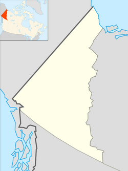
Yukon is the westernmost of Canada's three northern territories. Its capital is Whitehorse. People from Yukon are known as Yukoners. Unlike in other Canadian provinces and territories, Statistics Canada uses the entire territory as a single at-large census division.
Lake Cowichan is a town located on the east end of Cowichan Lake and, by highway, is 27 kilometres (17 mi) west of Duncan, British Columbia. The town of Lake Cowichan was incorporated in 1944. The Cowichan River flows through the middle of the town. Cowichan River is designated as a Heritage River.

Stanley is a rural municipality (RM) in the province of Manitoba in Western Canada. It is located in the southern part of the province, along its border with the state of North Dakota in the United States. Since 1876, the area made up part of the Mennonite West Reserve. The municipality has a population of 8,969 as of the 2016 Canada Census. The cities of Winkler and Morden lie geographically within the municipality but are separate urban municipalities.

Portage la Prairie is a rural municipality (RM) in the province of Manitoba in Western Canada. It surrounds the city of Portage la Prairie, Manitoba's fifth-largest city. Also within the borders of the municipality are the Dakota Plains First Nation and most of the Long Plain First Nation Indian reserves.
According to the 2021 census, the City of Edmonton had a population of 1,010,899 residents, compared to 4,262,635 for all of Alberta, Canada. The total population of the Edmonton census metropolitan area (CMA) was 1,418,118, making it the sixth-largest CMA in Canada.
Fort St. James is a district municipality and former fur trading post in northern central British Columbia, Canada. It is located on the south-eastern shore of Stuart Lake in the Omineca Country, at the northern terminus of Highway 27, which connects to Highway 16 at Vanderhoof.

In the 2021 Census, the City of Calgary had a population of 1,306,784 residents, representing 30.7% of the 4,262,635 residents in all of Alberta, and 3.5% compared to a population of 36,991,981 in all of Canada. The total population of the Calgary census metropolitan area (CMA) was 1,481,806. Calgary is the largest city in Alberta, and the third-largest municipality and fifth-largest metropolitan area in Canada, as of 2021.