Pelly Crossing

Last updated

Pelly Crossing and Pelly River (August 2017). Pelly Crossing, Yukon, Canada, 2017-08-27, DD 06-11 PAN.jpg
Pelly Crossing and Pelly River (August 2017).

Pelly Crossing is a community in Yukon, Canada. It lies where the Klondike Highway crosses the Pelly River.

Contents

It is the home of the Selkirk First Nation, and home to the Northern Tutchone culture. Cultural displays and artifacts are housed in a replica of Big Jonathan House. Visitors can make the journey from Minto by boat to visit the original structure down the Yukon River at Fort Selkirk, an important historic and cultural site for the Northern Tutchone people.

History

The Selkirk First Nation community was established as a ferry crossing and a highway construction camp when the Klondike Highway from Whitehorse to Dawson City was built in 1950. With the completion of the Pelly River bridge and the road to Dawson City, sternwheeler traffic on the Yukon River came to a halt. Fort Selkirk, located near the confluence of Pelly and Yukon Rivers, was virtually abandoned. The Government of Canada forced members of Selkirk First Nation to move from Fort Selkirk to Minto Landing before settling at Pelly Crossing. Today, the restored Fort Selkirk is a common stop for Yukon River travelers.[ citation needed ]

Geography

Pelly Crossing is located on the Pelly River, 155 miles south of Dawson City on the Klondike Highway.

Climate

Pelly Crossing has a severely continental subarctic climate (Dfc) with short but warm summers, but with the vast majority of the year being dominated by the bitterly cold winters. During cold snaps temperatures approaching −60 °C (−76 °F) has been recorded. The weather is rather dry and summer nights remain cool.

Climate data for Pelly Ranch, Yukon (1981-2010): 445m
MonthJanFebMarAprMayJunJulAugSepOctNovDecYear
Record high °C (°F)10.0
(50.0)
12.2
(54.0)
12.8
(55.0)
23.5
(74.3)
32.5
(90.5)
35.0
(95.0)
33.0
(91.4)
33.0
(91.4)
25.6
(78.1)
23.0
(73.4)
13.9
(57.0)
12.8
(55.0)
35.0
(95.0)
Mean daily maximum °C (°F)−19.7
(−3.5)
−12.8
(9.0)
−1.7
(28.9)
8.3
(46.9)
15.7
(60.3)
21.5
(70.7)
22.8
(73.0)
19.8
(67.6)
12.8
(55.0)
1.8
(35.2)
−12.1
(10.2)
−16.7
(1.9)
3.3
(37.9)
Daily mean °C (°F)−24.9
(−12.8)
−19.5
(−3.1)
−10.6
(12.9)
0.7
(33.3)
8.3
(46.9)
13.9
(57.0)
15.8
(60.4)
12.8
(55.0)
6.5
(43.7)
−2.5
(27.5)
−16.3
(2.7)
−21.9
(−7.4)
−3.1
(26.3)
Mean daily minimum °C (°F)−30.1
(−22.2)
−26.2
(−15.2)
−19.4
(−2.9)
−6.8
(19.8)
0.9
(33.6)
5.8
(42.4)
8.7
(47.7)
5.7
(42.3)
0.3
(32.5)
−6.7
(19.9)
−20.4
(−4.7)
−27.0
(−16.6)
−9.6
(14.7)
Record low °C (°F)−58.9
(−74.0)
−60.0
(−76.0)
−50.0
(−58.0)
−38.3
(−36.9)
−12.2
(10.0)
−4.0
(24.8)
−2.8
(27.0)
−7.0
(19.4)
−20.0
(−4.0)
−37.0
(−34.6)
−51.0
(−59.8)
−56.7
(−70.1)
−60.0
(−76.0)
Average precipitation mm (inches)19.7
(0.78)
14.9
(0.59)
10.6
(0.42)
8.9
(0.35)
27.2
(1.07)
38.5
(1.52)
58.0
(2.28)
41.4
(1.63)
31.6
(1.24)
24.5
(0.96)
25.8
(1.02)
19.4
(0.76)
320.5
(12.62)
Average snowfall cm (inches)19.7
(7.8)
14.9
(5.9)
10.5
(4.1)
5.1
(2.0)
0.5
(0.2)
0.0
(0.0)
0.0
(0.0)
0.0
(0.0)
2.7
(1.1)
15.6
(6.1)
25.8
(10.2)
19.4
(7.6)
114.2
(45)
Average precipitation days (≥ 0.2 mm)8.76.85.04.810.511.314.412.511.510.710.89.1116.1
Average snowy days (≥ 0.2 cm)8.76.85.02.60.20.00.00.01.27.310.89.151.8
Source: Environment and Climate Change Canada [1]

Demographics

Federal census population history of Pelly Crossing
YearPop.±%
1981182    
1986177−2.7%
1991 216+22.0%
1996 238+10.2%
2001 328+37.8%
2006 296−9.8%
2011 336+13.5%
2016 353+5.1%
2021 316−10.5%
Source: Statistics Canada
[2] [3] [4] [5] [6] [7] [8] [9]

In the 2021 Census of Population conducted by Statistics Canada, Pelly Crossing had a population of 316 living in 139 of its 159 total private dwellings, a change of

Attractions

The local community is based on hunting, trapping, fishing and guiding. There is a school, curling rink, baseball field, swimming pool, and youth centre.[ citation needed ]

Sports

Every February, Pelly Crossing hosts a checkpoint for the long-distance Yukon Quest sled dog race.[ citation needed ]

Related Research Articles

<span class="mw-page-title-main">Yukon</span> Territory of Canada

Yukon is the smallest and westernmost of Canada's three territories. It is the second-least populated province or territory in Canada, with a population of 45,148 as of 2023. However, Whitehorse, the territorial capital, is the largest settlement in any of the three territories.

<span class="mw-page-title-main">Beaver Creek, Yukon</span> Place in Yukon, Canada

Beaver Creek is a community in Yukon, Canada. Located at kilometre 1870.6 of the Alaska Highway, 1 NM southeast of Beaver Creek Airport and close to the Alcan - Beaver Creek Border Crossing, it is Canada's westernmost community. The community's main employers are a Canada Border Services Agency port, the White River First Nation and a number of tourist lodges.

<span class="mw-page-title-main">Faro, Yukon</span> Town in Yukon, Canada

Faro is a town in central Yukon, Canada, the home of the now abandoned Faro Mine. It was the largest open-pit lead–zinc mine in the world as well as a significant producer of silver and other natural resources. The mine was built by the Ralph M. Parsons Construction Company of the United States with General Enterprises Ltd. of Whitehorse being the main subcontractor. As of 2021, the population is 440, down from its peak population of 1,652 in 1981. Faro was named after the card game of the same name.

<span class="mw-page-title-main">Dawson City</span> City in Yukon, Canada

Dawson City, officially the City of Dawson, is a city in the Canadian territory of Yukon. It is inseparably linked to the Klondike Gold Rush (1896–1899). Its population was 1,577 as of the 2021 census, making it the second-largest city in Yukon.

<span class="mw-page-title-main">Carcross</span> Place in Yukon, Canada

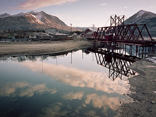
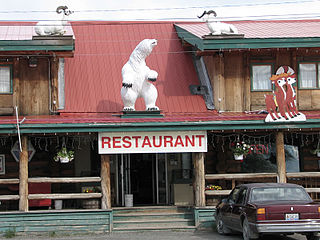
Carcross, originally known as Caribou Crossing, is an unincorporated community in Yukon, Canada, on Bennett Lake and Nares Lake. It is home to the Carcross/Tagish First Nation.

<span class="mw-page-title-main">Haines Junction, Yukon</span> Village in Yukon, Canada

Haines Junction is a village in Yukon, Canada. It is at Kilometre 1,632 of the Alaska Highway at its junction with the Haines Highway, hence the name of the community. According to the 2021 Census, the population was 688. However, the Yukon Bureau of Statistics lists the population count for 2022 as 1,018.

<span class="mw-page-title-main">Burwash Landing</span> Place in Yukon, Canada

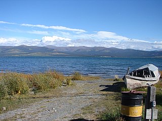
Burwash Landing is a small community, at historical mile 1093 on the Alaska Highway, in Yukon, Canada along the southern shore of Kluane Lake.

<span class="mw-page-title-main">Carmacks, Yukon</span> Village in Yukon, Canada

Carmacks is a village in Yukon, Canada, on the Yukon River along the Klondike Highway, and at the west end of the Robert Campbell Highway from Watson Lake. The population is 588, an increase from the Census of 2016. It is the home of the Little Salmon/Carmacks First Nation, a Northern Tutchone-speaking people.

The Selkirk First Nation (Hucha Hudan people) is a First Nation self-government in the Canadian territory, Yukon. Its original population centre was the trading post of Fort Selkirk, Yukon along the Yukon River, but most of its citizens now live in Pelly Crossing, Yukon where the Klondike Highway crosses the Pelly River. The language originally spoken by the Selkirk people was Northern Tutchone. There is a great effort to preserve the language and culture, as can be seen by the popularity of the Selkirk "Keeper of the Songs", Jerry Alfred.

<span class="mw-page-title-main">Mayo, Yukon</span> Village in Yukon, Canada

Mayo is a village in Yukon, Canada, along the Silver Trail and the Stewart River. It had a population of 200 in 2016. The Yukon Bureau of Statistics estimated a population of 496 in 2019. It is also the home of the First Nation of Na-Cho Nyak Dun, whose primary speak the northern variety of the Tutchone language. Na-Cho Nyäk Dun translates into "big river people."

<span class="mw-page-title-main">Ross River, Yukon</span>

Ross River is an unincorporated community in Yukon, Canada. It lies at the junction of the Ross River and the Pelly River, along the Canol Road, not far from the Campbell Highway. Primary access to the Campbell Highway is via a nine-mile access road. Formerly it was accessed along a six-mile Canol Road section that is no longer maintained. It is serviced by Ross River Airport, used mainly for charter and scheduled flights to and from Whitehorse and Watson Lake.

<span class="mw-page-title-main">Tagish, Yukon</span> Place in Yukon, Canada

Tagish is an unincorporated community in Yukon, Canada. It is 30 kilometres (19 mi) east of Carcross, Yukon, on the Tagish Road at the northern end of Tagish Lake. The greater Tagish area also includes the Tagish Estates, Tagish Beach and Taku subdivisions, the latter two developed for cottages but now serving for many year-round homes. Tagish Beach and Taku have their own community hall. The Tagish Road was built in 1942 as part of an oil pipeline project, and the community sprouted around a bridge built over the narrow water between Tagish Lake and Marsh Lake.

<span class="mw-page-title-main">Champagne Landing</span> Place in Yukon, Canada

Champagne Landing or Champagne Landing 10 is a First Nations settlement in Yukon, Canada. It is located on the Alaska Highway. Its residents are citizens of the Champagne and Aishihik First Nations.

Mount Lorne is a hamlet in Canada's Yukon. The hamlet is considered a local advisory area with an advisory council providing local government.

Upper Liard is a chiefly First Nation settlement immediately west of Watson Lake in Canada's Yukon. It is situated at historical mile 642 of the Alaska Highway. Most of the residents are citizens of the Liard River First Nation, who also prominently populate the Two Mile area just north of Watson Lake.

<span class="mw-page-title-main">Johnsons Crossing</span> Settlement in Yukon, Canada

Johnsons Crossing or Johnson's Crossing is a settlement in Yukon, Canada. It is located at historical mile 836 of the Alaska Highway, at the junction of the Canol Road where the highway crosses the Teslin River.

<span class="mw-page-title-main">Stewart Crossing</span> Settlement in Yukon, Canada

Stewart Crossing is a settlement in Yukon, Canada located on the Stewart River. It is about 179 km east of Dawson City on the Klondike Highway, near the junction with the Silver Trail, from which it is about 53 km (33 mi) southwest of Mayo. A Yukon government highway maintenance camp and a highway lodge are the most prominent facilities at Stewart Crossing. The settlement is named for where the Klondike Highway, crossed the Stewart River by means of a ferry from 1950 until completion of a bridge in the mid-1950s.

<span class="mw-page-title-main">Swift River, Yukon</span> Human settlement in Yukon, Canada

Swift River is a settlement in the Canadian territory of Yukon, primarily a service stop on the Alaska Highway at historical mile 733. The radius of the area is estimated to be about 22.71 square kilometres ). The only permanent population owns and operates, or is employed at, the area's commercial highway establishment. Other residents are transient, working at the Yukon government's highway maintenance camp.

<span class="mw-page-title-main">Unorganized Yukon</span> Unorganized area in Yukon, Canada

Unorganized Yukon, or Yukon, Unorganized, is the unorganized area covering the majority of Yukon, Canada. It represents 98% of Yukon's 474,712.64 km2 (183,287.57 sq mi) land mass, and is recognized as a census subdivision by Statistics Canada.

References

  1. "Pelly Ranch, Yukon". Canadian Climate Normals 1981–2010 (in English and French). Environment and Climate Change Canada. Retrieved 5 February 2024.
  2. "1986 Census: Population - Census Divisions and Census Subdivisions" (PDF). Statistics Canada. September 1987. Retrieved 30 January 2022.
  3. "91 Census: Census Divisions and Census Subdivisions - Population and Dwelling Counts" (PDF). Statistics Canada. April 1992. Retrieved 30 January 2022.
  4. "96 Census: A National Overview - Population and Dwelling Counts" (PDF). Statistics Canada. April 1997. Retrieved 30 January 2022.
  5. "Population and Dwelling Counts, for Canada, Provinces and Territories, and Census Subdivisions (Municipalities), 2001 and 1996 Censuses - 100% Data (Yukon Territory)". Statistics Canada. 15 August 2012. Retrieved 30 January 2022.
  6. "Population and dwelling counts, for Canada, provinces and territories, and census subdivisions (municipalities), 2006 and 2001 censuses - 100% data (Yukon Territory)". Statistics Canada. 20 August 2021. Retrieved 30 January 2022.
  7. "Population and dwelling counts, for Canada, provinces and territories, and census subdivisions (municipalities), 2011 and 2006 censuses (Yukon)". Statistics Canada. 25 July 2021. Retrieved 30 January 2022.
  8. "Population and dwelling counts, for Canada, provinces and territories, and census subdivisions (municipalities), 2016 and 2011 censuses – 100% data (Yukon)". Statistics Canada. 8 February 2017. Retrieved 30 January 2022.
  9. 1 2 "Population and dwelling counts: Canada, provinces and territories, and census subdivisions (municipalities), Yukon". Statistics Canada. 9 February 2022. Retrieved 18 February 2022.

62°50′N136°35′W / 62.833°N 136.583°W / 62.833; -136.583