This article needs additional citations for verification .(December 2009) (Learn how and when to remove this template message) |
| Pelly River | |
|---|---|
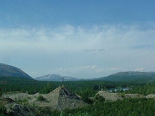
 Pelly River at Pelly Crossing | |
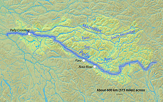
 Map of the Pelly River | |
| Etymology | Named by Robert Campbell in honour of Sir John Henry Pelly, governor of the Hudson's Bay Company. |
| Location | |
| Country | Canada |
| State | Yukon |
| Cities | Ross River, Faro, Pelly Crossing |
| Physical characteristics | |
| Source | Mackenzie Mountains |
| - location | An unnamed glacier |
| - coordinates | 62°26′32″N129°11′34″W / 62.44222°N 129.19278°W |
| - elevation | 1,465 m (4,806 ft) |
| Mouth | Yukon River |
| - coordinates | 62°46′37″N137°20′48″W / 62.77694°N 137.34667°W Coordinates: 62°46′37″N137°20′48″W / 62.77694°N 137.34667°W |
| - elevation | 458 m (1,503 ft) |
| Length | 530 km (330 mi), East-southeast to west-northwest |
| Discharge | |
| - minimum | 35 m3/s (1,200 cu ft/s) |
| - average | 700 m3/s (25,000 cu ft/s) |
| - maximum | 4,160 m3/s (147,000 cu ft/s) |
| Basin features | |
| Basin size | 49,000 km2 (19,000 sq mi) |
| Tributaries | |
| - right | Ross River, Tay River (Yukon), Macmillan River |
The Pelly River is a river in Canada, and is a headstream of the Yukon River. The river originates west of the Mackenzie Mountains and flows 530 km (329 mi) long through the south central Yukon. The Pelly has two main tributaries, the Ross and Macmillan rivers.

Canada is a country in the northern part of North America. Its ten provinces and three territories extend from the Atlantic to the Pacific and northward into the Arctic Ocean, covering 9.98 million square kilometres, making it the world's second-largest country by total area. Canada's southern border with the United States, stretching some 8,891 kilometres (5,525 mi), is the world's longest bi-national land border. Its capital is Ottawa, and its three largest metropolitan areas are Toronto, Montreal, and Vancouver. As a whole, Canada is sparsely populated, the majority of its land area being dominated by forest and tundra. Consequently, its population is highly urbanized, with over 80 percent of its inhabitants concentrated in large and medium-sized cities, with 70% of citizens residing within 100 kilometres (62 mi) of the southern border. Canada's climate varies widely across its vast area, ranging from arctic weather in the north, to hot summers in the southern regions, with four distinct seasons.

The Yukon River is a major watercourse of northwestern North America. The river's source is in British Columbia, Canada, from which it flows through the Canadian Yukon Territory. The lower half of the river lies in the U.S. state of Alaska. The river is 3,190 kilometres (1,980 mi) long and empties into the Bering Sea at the Yukon–Kuskokwim Delta. The average flow is 6,430 m3/s (227,000 ft3/s). The total drainage area is 832,700 km2 (321,500 mi2), of which 323,800 km2 (126,300 mi2) is in Canada. The total area is more than 25% larger than Texas or Alberta.

The Mackenzie Mountains are a mountain range forming part of the Yukon-Northwest Territories boundary between the Liard and Peel rivers. The range is named in honour of Canada's second prime minister, Alexander Mackenzie, as well as the explorer. Nahanni National Park Reserve and Nááts'ihch'oh National Park Reserve are in the Mackenzie Mountains.
Contents

The river was named by Robert Campbell in honour of Sir John Henry Pelly, governor of the Hudson's Bay Company. The restored Hudson's Bay Company trading post of Fort Selkirk is at the juncture of the Pelly and Yukon Rivers.
Robert Campbell was a Hudson's Bay Company fur trader and explorer. He explored a large part of the southern Yukon and northern British Columbia. He established the short-lived Dease Lake Post, and in 1838 he was the first European to reach the Stikine River overland. He established Fort Frances, Yukon on Frances Lake in the Liard River basin. In 1840 he crossed from Frances Lake to the Pelly River becoming the first European to explore the upper Yukon River Basin. He established Fort Selkirk, Yukon at the juncture of the Yukon River and the Pelly River.
The Hudson's Bay Company is a Canadian retail business group. A fur trading business for much of its existence, HBC now owns and operates retail stores in Canada, the United States, and parts of Europe including Belgium, the Netherlands, and Germany. The company's namesake business division is Hudson's Bay, commonly referred to as The Bay. Other divisions include Galeria Kaufhof, Home Outfitters, Lord & Taylor and Saks Fifth Avenue. HBC's head office is currently located in Brampton, Ontario. The company is listed on the Toronto Stock Exchange under the symbol "HBC".