
The Rocky Mountains, also known as the Rockies, are a major mountain range and the largest mountain system in North America. The Rocky Mountains stretch 3,000 miles in straight-line distance from the northernmost part of western Canada, to New Mexico in the southwestern United States. Depending on differing definitions between Canada and the U.S., its northern terminus is located either in northern British Columbia's Terminal Range south of the Liard River and east of the Trench, or in the northeastern foothills of the Brooks Range/British Mountains that face the Beaufort Sea coasts between the Canning River and the Firth River across the Alaska-Yukon border. Its southernmost point is near the Albuquerque area adjacent to the Rio Grande rift and north of the Sandia–Manzano Mountain Range. Being the easternmost portion of the North American Cordillera, the Rockies are distinct from the tectonically younger Cascade Range and Sierra Nevada, which both lie farther to its west.

Yukon is the smallest and westernmost of Canada's three territories. It is the most densely populated territory in Canada, with a population of 45,750 as of 2024, though it has a smaller population than all provinces. Whitehorse, the territorial capital, is the largest settlement in any of the three territories.

The Mackenzie River is a river in the Canadian boreal forest. It forms, along with the Slave, Peace, and Finlay, the longest river system in Canada, and includes the second largest drainage basin of any North American river after the Mississippi.

The Canadian Rockies or Canadian Rocky Mountains, comprising both the Alberta Rockies and the British Columbian Rockies, is the Canadian segment of the North American Rocky Mountains. It is the easternmost part of the Canadian Cordillera, which is the northern segment of the North American Cordillera, the expansive system of interconnected mountain ranges between the Interior Plains and the Pacific Coast that runs northwest–southeast from central Alaska to the Isthmus of Tehuantepec in Mexico.
The Dempster Highway, also referred to as Yukon Highway 5 and Northwest Territories Highway 8, is a highway in Canada that connects the Klondike Highway in Yukon to Inuvik, Northwest Territories on the Mackenzie River delta. The highway crosses the Peel and the Mackenzie rivers using a combination of seasonal ferry services and ice bridges. Year-round road access from Inuvik to Tuktoyaktuk opened in November 2017, with the completion of the Inuvik–Tuktoyaktuk Highway, creating the first all-weather road route connecting the Canadian road network with the Arctic Ocean.

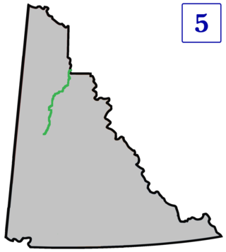
The Liard River of the North American boreal forest flows through Yukon, British Columbia and the Northwest Territories, Canada. Rising in the Saint Cyr Range of the Pelly Mountains in southeastern Yukon, it flows 1,115 km (693 mi) southeast through British Columbia, marking the northern end of the Rocky Mountains and then curving northeast back into Yukon and Northwest Territories, draining into the Mackenzie River at Fort Simpson, Northwest Territories. The river drains approximately 277,100 km2 (107,000 sq mi) of boreal forest and muskeg.

The Pelly River is a river in Canada, and is a headstream of the Yukon River. The river originates west of the Mackenzie Mountains and flows 530 km (330 mi) through south-central Yukon. The Pelly has two main tributaries, the Ross and Macmillan rivers.

Yukon is in the northwestern corner of Canada and is bordered by Alaska, British Columbia and the Northwest Territories. The sparsely populated territory abounds with natural scenery, snowmelt lakes and perennial white-capped mountains, including many of Canada's highest mountains. The territory's climate is Arctic in territory north of Old Crow, subarctic in the region, between Whitehorse and Old Crow, and humid continental climate south of Whitehorse and in areas close to the British Columbia border. Most of the territory is boreal forest with tundra being the main vegetation zone only in the extreme north and at high elevations.
The Kaska or Kaska Dena are a First Nations people of the Athabaskan-speaking ethnolinguistic group living mainly in northern British Columbia and the southeastern Yukon in Canada. The Kaska language, originally spoken by the Kaska, is an Athabaskan language.
The Pacific Cordillera, also known as the Western Cordillera or simply The Cordillera, is a top-level physiographic region of Canada, referring mainly to the extensive cordillera system in Western and Northwestern Canada that constitutes the northern part of the North American Cordillera. The mountain ranges in this region were covered during the Pleistocene by the Cordilleran Ice Sheet, the extent of which gives perspective on the geographic extent of this region. The cordillera extends from the Alaska's Brooks and Alaska Ranges, southeast through most of the Yukon and British Columbia as well as the southwestern fringe of Northwest Territories and Alberta, to stretch its margin beyond the Canada–United States border with five extensive lobes reaching into the mountain valleys of Montana and Washington.

The Rocky Mountain Trench, also known as the Valley of a Thousand Peaks or simply the Trench, is a large valley on the western side of the northern part of North America's Rocky Mountains. The Trench is both visually and cartographically a striking physiographic feature extending approximately 1,600 km (1,000 mi) from Flathead Lake, Montana, to the Liard River, just south of the British Columbia–Yukon border near Watson Lake, Yukon. The trench bottom is 3–16 km (1.9–9.9 mi) wide and is 600–900 m (2,000–3,000 ft) above sea level. The general orientation of the Trench is an almost straight 150/330° geographic north vector and has become convenient as a visual guide for aviators heading north or south.

The North American Cordillera, sometimes also called the Western Cordillera of North America, the Western Cordillera, or the Pacific Cordillera, is the North American portion of the American Cordillera, the mountain chain system along the Pacific coast of the Americas. The North American Cordillera covers an extensive area of mountain ranges, intermontane basins, and plateaus in Western and Northwestern Canada, Western United States, and Mexico, including much of the territory west of the Great Plains.

The Kechika River is a tributary of the Liard River, about 300 kilometres (190 mi) long, in northern British Columbia, Canada. The Kechika flows generally northwest through the northernmost section of the Rocky Mountain Trench before turning east to join the Liard, a major branch of the Mackenzie River system. The river's 22,700 km2 (8,800 sq mi) drainage basin is characterized by high glaciated peaks, boreal forest, and open tundra. With no settlements, roads or dams along its course, the Kechika is considered "one of British Columbia's finest examples of wilderness and undisturbed wildlife habitat."

The Northern Cordilleran Volcanic Province (NCVP), formerly known as the Stikine Volcanic Belt, is a geologic province defined by the occurrence of Miocene to Holocene volcanoes in the Pacific Northwest of North America. This belt of volcanoes extends roughly north-northwest from northwestern British Columbia and the Alaska Panhandle through Yukon to the Southeast Fairbanks Census Area of far eastern Alaska, in a corridor hundreds of kilometres wide. It is the most recently defined volcanic province in the Western Cordillera. It has formed due to extensional cracking of the North American continent—similar to other on-land extensional volcanic zones, including the Basin and Range Province and the East African Rift. Although taking its name from the Western Cordillera, this term is a geologic grouping rather than a geographic one. The southmost part of the NCVP has more, and larger, volcanoes than does the rest of the NCVP; further north it is less clearly delineated, describing a large arch that sways westward through central Yukon.

The South Nahanni River is a major tributary of the Liard River, located roughly 500 km (310 mi) west of Yellowknife in the Northwest Territories of Canada. It is the centerpiece of Nahanni National Park Reserve. It flows from the Mackenzie Mountains in the west, through the Selwyn Mountains, growing as it heads east over the majestic Virginia Falls, and finally empties into the Liard River. The Nahanni has a unique geological history. It was formed when the area was a broad flat plain, forming a winding course typical of flatland rivers. As the mountains lifted, the river cut four deep canyons into the rock, maintaining its eccentric course.

The history of the Yukon covers the period from the arrival of Paleo-Indians through the Beringia land bridge approximately 20,000 years ago. In the 18th century, Russian explorers began to trade with the First Nations people along the Alaskan coast, and later established trade networks extending into Yukon. By the 19th century, traders from the Hudson's Bay Company were also active in the region. The region was administered as a part of the North-Western Territory until 1870, when the United Kingdom transferred the territory to Canada and it became the North-West Territories.

Volcanism in Northern Canada has produced hundreds of volcanic areas and extensive lava formations across Northern Canada. The region's different volcano and lava types originate from different tectonic settings and types of volcanic eruptions, ranging from passive lava eruptions to violent explosive eruptions. Northern Canada has a record of very large volumes of magmatic rock called large igneous provinces. They are represented by deep-level plumbing systems consisting of giant dike swarms, sill provinces and layered intrusions.

The Indigenous peoples of Yukon are ethnic groups who, prior to European contact, occupied the former countries now collectively known as Yukon. While most First Nations in the Canadian territory are a part of the wider Dene Nation, there are Tlingit and Métis nations that blend into the wider spectrum of indigeneity across Canada. Traditionally hunter-gatherers, indigenous peoples and their associated nations retain close connections to the land, the rivers and the seasons of their respective countries or homelands. Their histories are recorded and passed down the generations through oral traditions. European contact and invasion brought many changes to the native cultures of Yukon including land loss and non-traditional governance and education. However, indigenous people in Yukon continue to foster their connections with the land in seasonal wage labour such as fishing and trapping. Today, indigenous groups aim to maintain and develop indigenous languages, traditional or culturally-appropriate forms of education, cultures, spiritualities and indigenous rights.
The geology of Yukon includes sections of ancient Precambrian Proterozoic rock from the western edge of the proto-North American continent Laurentia, with several different island arc terranes added through the Paleozoic, Mesozoic and Cenozoic, driving volcanism, pluton formation and sedimentation.