Faro, Yukon

Last updated • 5 min readFrom Wikipedia, The Free Encyclopedia

Faro
Town
Town of Faro
Town of Faro.jpg
Faro and Pelly River
Location map Yukon 2.png
Red pog.svg
Faro
Canada location map 2.svg
Red pog.svg
Faro
Coordinates: 62°13′35″N133°21′21″W / 62.22639°N 133.35583°W / 62.22639; -133.35583 [1]
CountryCanada
Territory Yukon
Area
[3]
  Land199.89 km2 (77.18 sq mi)
Elevation
At airport [4]
720 m (2,350 ft)
Population
 (2021) [3]
  Total
440
  Density2.2/km2 (6/sq mi)
  Change 2016–21
Increase2.svg26.4%
Demonym Faroite
Time zone UTC– 07:00 (MST)
Climate Dfc
Website Official website

Faro is a town in central Yukon, Canada, the home of the now abandoned Faro Mine. It was the largest open-pit lead–zinc mine in the world as well as a significant producer of silver and other natural resources. The mine was built by the Ralph M. Parsons Construction Company of the United States with General Enterprises Ltd. of Whitehorse being the main subcontractor. As of 2021, the population is 440, down from its peak population of 1,652 in 1981. Faro was named after the card game of the same name. [5]

Contents

As these industries have declined over the past decade, Faro is attempting to attract ecotourism to the region to view such animals as Dall and Stone sheep. Both species of sheep are almost unique to the surrounding area. Several viewing platforms have been constructed in and around the town.

One unusual feature of Faro is that it has a golf course running through the main part of town. [6]

History

The area was prospected in the 1950s and 1960s by Al Kulan, [5] credited with discovering several significant deposits of lead and zinc ore and playing a major role in the discovery of the Faro Mine, which became Canada's largest lead-zinc mine. [7] The Cyprus Anvil Mining Corporation [5] established the first operations to mine the deposits, and established the town of Faro. A new highway was built between Carmacks and Ross River to serve the Faro area – initially numbered Highway 9, it is today part of the Robert Campbell Highway, Yukon Highway 4. A forest fire in 1969 destroyed the newly built homes, which had to be re-built.

On 26 October 2021, two people were killed and another critically injured in an active shooter situation in Faro. A suspect, identified as a local resident, was taken into custody by police and charged with two counts each of first-degree murder, attempted murder, and aggravated assault. Flags were lowered to half-mast in Whitehorse and Dawson City in response to the killings. [8]

Demographics

Federal census population history of Faro
YearPop.±%
1971863    
19761,544+78.9%
19811,652+7.0%
1986400−75.8%
1991 1,221+205.3%
1996 1,261+3.3%
2001 313−75.2%
2006 341+8.9%
2011 344+0.9%
2016 348+1.2%
2021 440+26.4%
Source: Statistics Canada
[3] [9] [10] [11] [12] [13] [14] [15] [16] [17] [18]

In the 2021 Census of Population conducted by Statistics Canada, Faro had a population of 440 living in 210 of its 423 total private dwellings, a change of

Economy

Faro Mine

Faro Mine was once the largest open-pit lead-zinc mine in the world. Today, it is the site of one of the most complex abandoned mine remediation projects in Canada. The mine spans 25 km2, an area roughly the size of the city of Victoria, British Columbia.

Faro Mine Remediation Project: Yukon [19]

The mine was opened by the Cyprus Anvil Mining Corporation in 1969, which was formed to mine the deposit. [20] From the late 1960s until 1982 the mine was one of the largest lead-zinc mines in the world. At one time it was the largest open-pit mine in the world. During its history, 320 million tonnes of waste rock was removed to reach the ore. The mine remained in more-or-less constant production until 1982. Trucks carried the ore concentrate from the mill by highway to Whitehorse, where the buckets were lifted from the trucks and lowered onto cars of the White Pass and Yukon Route railway. The trains took the buckets another 170 km (110 mi) to Skagway, Alaska, where the contents were poured out into the holds of ships.

During those years, Cyprus Anvil was purchased by Dome Petroleum. World prices for metals fell in 1982, and the mine owners announced in May a two-month halt to production starting in June, 1982. In July, the mine owners extended the shutdown to four months. In September, the owners announced that the shutdown would be indefinite. The shock to the Yukon economy, where the mine produced approximately 40% of territorial GDP, was enormous. [21] With government assistance an 18-month waste-rock stripping program was operated in 1983 and 1984. Curragh Resources purchased the property in 1985 and production resumed in 1986. [22] This time, ore was trucked in ore pots from Faro directly to Skagway, bypassing the railway. This operation ended in 1993, not long after Curragh Resources suffered a coal mining disaster at the Westray Mine in Plymouth, Pictou County, Nova Scotia. A third operation, by the Anvil Range Mining Corporation, opened in 1995 and ceased production in January 1998, followed by the bankruptcy of Anvil Range. Much of the heavy mining and milling equipment was sold and removed from the Yukon.

Any prospect for further mining of the lead-zinc resource would now require significant investment to bring in mining equipment, and it would need to come entirely by road unless a British Columbia-Alaska railway is built or the White Pass route is reopened to freight traffic to Whitehorse. Cost of clean-up is estimated at close to a billion dollars. [23]

When the mine closed it left 70 million tonnes of tailings and 320 million tonnes of waste rock that require remediation to protect the health of humans, land, water, and wildlife. [24] With the bankruptcy of Anvil Range the clean up bill for the mine and tailings pond fell to the federal government. Early estimates put the cost at $450–590 million over 40 years. In 2016 the federal treasury reported that between $250 million and $350 million had been spent maintaining the mine site, without starting clean-up. The $40 million annual costs are to run pumps to prevent the tailings from breaching the dams and the construction and operations of three water treatment plants. The clean-up itself could cost a further $1-billion. [25]

In a report by the Canadian Broadcasting Corporation in 2017, the Canadian government stated that they were prepared to embark on the remediation process of the Faro Mine. The concerns listed by federal officials include the leaching of toxic metals into the Pelly and Yukon rivers as the acidic rock drainage worsens over time. The remediation work will include rerouting regional creeks to avoid tailings and waste rock areas, treating contaminated water, and avoiding clean water from becoming contaminated. [26]

Infrastructure

The town is served by the Faro Airport and the Robert Campbell Highway passes through just south of Faro.

Geography

Climate

Faro has a subarctic climate (Köppen Dfc) with mild summers and severely cold winters. Extreme seasonal swings are common, although less severe than farther east in Canada due to the warm spells in summers and occasional mild spells in winter.

Climate data for Faro (Faro Airport)
Climate ID: 2100517; coordinates 62°12′25″N133°22′24″W / 62.20694°N 133.37333°W / 62.20694; -133.37333 (Faro Airport) ; elevation: 716.3 m (2,350 ft); 1981–2010 normals
MonthJanFebMarAprMayJunJulAugSepOctNovDecYear
Record high humidex 5.410.811.419.629.735.433.932.823.917.812.011.735.4
Record high °C (°F)7.0
(44.6)
12.1
(53.8)
12.5
(54.5)
21.5
(70.7)
32.0
(89.6)
33.8
(92.8)
31.0
(87.8)
33.9
(93.0)
24.0
(75.2)
18.5
(65.3)
12.5
(54.5)
12.5
(54.5)
33.9
(93.0)
Mean daily maximum °C (°F)−16.0
(3.2)
−10.3
(13.5)
−2.1
(28.2)
6.8
(44.2)
13.8
(56.8)
19.6
(67.3)
21.0
(69.8)
18.4
(65.1)
11.5
(52.7)
1.7
(35.1)
−11.1
(12.0)
−13.8
(7.2)
3.3
(37.9)
Daily mean °C (°F)−20.1
(−4.2)
−15.5
(4.1)
−8.6
(16.5)
0.6
(33.1)
7.5
(45.5)
13.2
(55.8)
15.0
(59.0)
12.4
(54.3)
6.4
(43.5)
−2.0
(28.4)
−14.8
(5.4)
−17.9
(−0.2)
−2.0
(28.4)
Mean daily minimum °C (°F)−24.6
(−12.3)
−20.7
(−5.3)
−15.0
(5.0)
−5.5
(22.1)
1.2
(34.2)
6.8
(44.2)
8.9
(48.0)
6.3
(43.3)
1.3
(34.3)
−5.7
(21.7)
−18.5
(−1.3)
−22.3
(−8.1)
−7.3
(18.9)
Record low °C (°F)−51.0
(−59.8)
−51.0
(−59.8)
−44.0
(−47.2)
−30.5
(−22.9)
−8.0
(17.6)
−2.5
(27.5)
0.0
(32.0)
−4.5
(23.9)
−15.5
(4.1)
−34.0
(−29.2)
−46.0
(−50.8)
−52.0
(−61.6)
−52.0
(−61.6)
Record low wind chill −59.1−58.9−53.1−34.2−16.40.00.0−2.4−13.0−30.4−58.3−60.0−60.0
Average precipitation mm (inches)14.6
(0.57)
12.3
(0.48)
12.3
(0.48)
8.7
(0.34)
27.9
(1.10)
36.7
(1.44)
56.1
(2.21)
48.2
(1.90)
41.0
(1.61)
27.3
(1.07)
19.4
(0.76)
15.2
(0.60)
319.7
(12.59)
Average rainfall mm (inches)0.0
(0.0)
0.0
(0.0)
0.1
(0.00)
2.6
(0.10)
27.3
(1.07)
36.7
(1.44)
56.1
(2.21)
47.5
(1.87)
38.4
(1.51)
9.4
(0.37)
0.2
(0.01)
0.1
(0.00)
218.4
(8.60)
Average snowfall cm (inches)16.7
(6.6)
14.6
(5.7)
13.1
(5.2)
6.3
(2.5)
0.6
(0.2)
0.0
(0.0)
0.0
(0.0)
0.7
(0.3)
2.4
(0.9)
20.4
(8.0)
21.7
(8.5)
17.6
(6.9)
114.0
(44.9)
Average precipitation days (≥ 0.2 mm)10.78.67.35.311.612.717.715.215.213.912.510.8141.4
Average rainy days (≥ 0.2 mm)0.00.00.11.511.212.717.715.014.25.00.20.177.8
Average snowy days (≥ 0.2 cm)11.18.97.44.00.60.00.00.21.49.512.911.467.4
Average relative humidity (%)79.271.954.841.447.950.455.463.781.281.062.7
Source: Environment Canada Canadian Climate Normals 1981–2010 [27]

People connected with Faro

See also

Related Research Articles

<span class="mw-page-title-main">Dawson City</span> Town in Yukon, Canada

Dawson City, officially the City of Dawson, is a town in the Canadian territory of Yukon. It is inseparably linked to the Klondike Gold Rush (1896–1899). Its population was 1,577 as of the 2021 census, making it the second-largest municipality in Yukon.

<span class="mw-page-title-main">Carcross</span> Place in Yukon, Canada

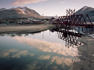
Carcross, originally known as Caribou Crossing, is an unincorporated community in Yukon, Canada, on Bennett Lake and Nares Lake. It is home to the Carcross/Tagish First Nation.

<span class="mw-page-title-main">Burwash Landing</span> Place in Yukon, Canada

Burwash Landing is a small community, at historical mile 1093 on the Alaska Highway, in Yukon, Canada along the southern shore of Kluane Lake.

Elsa is a former privately owned mining town in the Canadian territory of Yukon, between the Stewart River valley to the south and the Mackenzie Mountains to the north. It is located at Kilometre 97 of the Silver Trail, approximately 700 kilometres (435 mi) north of Whitehorse and 600 km (373 mi) east of the Alaskan border.

<span class="mw-page-title-main">Carmacks, Yukon</span> Village in Yukon, Canada

Carmacks is a village in Yukon, Canada, on the Yukon River along the Klondike Highway, and at the west end of the Robert Campbell Highway from Watson Lake. The population is 588, an increase from the Census of 2016. It is the home of the Little Salmon/Carmacks First Nation, a Northern Tutchone-speaking people.

<span class="mw-page-title-main">Watson Lake, Yukon</span> Town in Yukon, Canada

Watson Lake is a town in Yukon, Canada, located at mile 635 on the Alaska Highway close to the British Columbia border. It had a population of 1,133 in 2021. The town is named for Frank Watson, an American-born trapper and prospector, who settled in the area at the end of the 19th century.

<span class="mw-page-title-main">Keno City</span> Place in Yukon, Canada

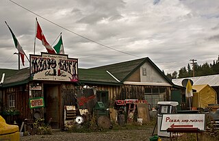
Keno City is a small community in Yukon, Canada at the end of the Silver Trail highway. Keno City was the site of a former silver-lead mining area proximal to Keno Hill. Keno City is 13 kilometres away from Elsa, Yukon, which is owned by Hecla mining who currently own and operate the various Ag-Pb-Zn deposits in the Keno Hill area. Rich silver and lead ore deposits were found on Keno Hill in 1919, and since then the population of the community has fluctuated in response to the mining activity in the area. When in 1989 United Keno Hill closed the mines, literally overnight, the people in the Keno area who decided to stay chose a more sustainable economy: tourism. They successfully marketed Keno City as a quiet, tranquil community.

<span class="mw-page-title-main">Mayo, Yukon</span> Village in Yukon, Canada

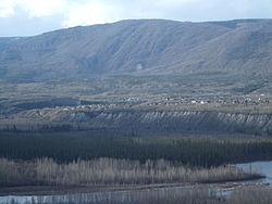
Mayo is a village in Yukon, Canada, along the Silver Trail and the Stewart River. It had a population of 200 in 2016. The Yukon Bureau of Statistics estimated a population of 496 in 2019. It is also the home of the First Nation of Na-Cho Nyak Dun, whose people primarily speak the northern variety of the Tutchone language. Na-Cho Nyäk Dun translates into "big river people."

<span class="mw-page-title-main">Ross River, Yukon</span> Unincorporated community in Yukon, Canada

Ross River is an unincorporated community in Yukon, Canada. It lies at the junction of the Ross River and the Pelly River, along the Canol Road, not far from the Campbell Highway. Primary access to the Campbell Highway is via a nine-mile access road. Formerly it was accessed along a six-mile Canol Road section that is no longer maintained. It is serviced by Ross River Airport, used mainly for charter and scheduled flights to and from Whitehorse and Watson Lake.

Pelly Crossing is a community in Yukon, Canada. It lies where the Klondike Highway crosses the Pelly River.

<span class="mw-page-title-main">Champagne Landing</span> Place in Yukon, Canada

Champagne Landing or Champagne Landing 10 is a First Nations settlement in Yukon, Canada. It is located on the Alaska Highway. Its residents are citizens of the Champagne and Aishihik First Nations.

<span class="mw-page-title-main">Destruction Bay</span> Place in Yukon, Canada

Destruction Bay is a small community on the Alaska Highway in Canada's Yukon on Kluane Lake.

<span class="mw-page-title-main">Ibex Valley, Yukon</span>

Ibex Valley is a hamlet in Canada's Yukon. The hamlet is considered a local advisory area with an advisory council providing local government. Its population, according to the 2021 Canadian Census, was 523.

Mount Lorne is a hamlet in Canada's Yukon. The hamlet is considered a local advisory area with an advisory council providing local government.

Marsh Lake is an unincorporated community on the Alaska Highway on the shores of Marsh Lake southeast of Whitehorse in Canada's Yukon. The area was organized in 2001, as a local area council to help the residents with some form of municipal government.

Upper Liard is a chiefly First Nation settlement immediately west of Watson Lake in Canada's Yukon. It is situated at historical mile 642 of the Alaska Highway. Most of the residents are citizens of the Liard River First Nation, who also prominently populate the Two Mile area just north of Watson Lake.

<span class="mw-page-title-main">Johnsons Crossing</span> Settlement in Yukon, Canada

Johnsons Crossing or Johnson's Crossing is a settlement in Yukon, Canada. It is located at historical mile 836 of the Alaska Highway, at the junction of the Canol Road where the highway crosses the Teslin River.

<span class="mw-page-title-main">Stewart Crossing</span> Settlement in Yukon, Canada

Stewart Crossing is a settlement in Yukon, Canada located on the Stewart River. It is about 179 km east of Dawson City on the Klondike Highway, near the junction with the Silver Trail, from which it is about 53 km (33 mi) southwest of Mayo. A Yukon government highway maintenance camp and a highway lodge are the most prominent facilities at Stewart Crossing. The settlement is named for where the Klondike Highway, crossed the Stewart River by means of a ferry from 1950 until completion of a bridge in the mid-1950s.

<span class="mw-page-title-main">Swift River, Yukon</span> Human settlement in Yukon, Canada

Swift River is a settlement in the Canadian territory of Yukon, primarily a service stop on the Alaska Highway at historical mile 733. The radius of the area is estimated to be about 22.71 square kilometres ). The only permanent population owns and operates, or is employed at, the area's commercial highway establishment. Other residents are transient, working at the Yukon government's highway maintenance camp.

References

  1. "Faro". Geographical Names Data Base . Natural Resources Canada.
  2. "Faro". Geographical Names Data Base . Natural Resources Canada.
  3. 1 2 3 4 "Population and dwelling counts: Canada, provinces and territories, and census subdivisions (municipalities), Yukon". Statistics Canada. 9 February 2022. Retrieved 18 February 2022.
  4. Canada Flight Supplement. Effective 0901Z 16 July 2020 to 0901Z 10 September 2020.
  5. 1 2 3 "History of Faro". Town of Faro. 2022. Retrieved 17 January 2022.
  6. Quilici, Don (18 July 2012). "Outdoors with Don Q: The Yukon's infamous Robert Campbell Highway". Carson Now. Carson City News, Carson, Nevada. Retrieved 28 July 2012.
  7. Guest, H. (2012). "Faro". The Canadian Encyclopedia. Historica-Dominion. Archived from the original on 27 February 2013. Retrieved 30 July 2012.
  8. "2 dead after shooting in Faro, Yukon: RCMP". CBC News. 27 October 2021. Retrieved 27 October 2021.
  9. "Table 2: Population of Census Subdivisions, 1921–1971". 1971 Census of Canada (PDF). Population. Vol. Census Subdivisions (Historical). Ottawa: Statistics Canada. July 1973. Retrieved 30 January 2022.
  10. "1976 Census of Canada: Population – Geographic Distributions" (PDF). Statistics Canada. June 1977. Retrieved 30 January 2022.
  11. "1981 Census of Canada: Census subdivisions in decreasing population order" (PDF). Statistics Canada. May 1992. Retrieved 30 January 2021.
  12. "1986 Census: Population – Census Divisions and Census Subdivisions" (PDF). Statistics Canada. September 1987. Retrieved 30 January 2022.
  13. "91 Census: Census Divisions and Census Subdivisions – Population and Dwelling Counts" (PDF). Statistics Canada. April 1992. Retrieved 30 January 2022.
  14. "96 Census: A National Overview – Population and Dwelling Counts" (PDF). Statistics Canada. April 1997. Retrieved 30 January 2022.
  15. "Population and Dwelling Counts, for Canada, Provinces and Territories, and Census Subdivisions (Municipalities), 2001 and 1996 Censuses – 100% Data (Yukon Territory)". Statistics Canada. 15 August 2012. Retrieved 30 January 2022.
  16. "Population and dwelling counts, for Canada, provinces and territories, and census subdivisions (municipalities), 2006 and 2001 censuses – 100% data (Yukon Territory)". Statistics Canada. 20 August 2021. Retrieved 30 January 2022.
  17. "Population and dwelling counts, for Canada, provinces and territories, and census subdivisions (municipalities), 2011 and 2006 censuses (Yukon)". Statistics Canada. 25 July 2021. Retrieved 30 January 2022.
  18. "Population and dwelling counts, for Canada, provinces and territories, and census subdivisions (municipalities), 2016 and 2011 censuses – 100% data (Yukon)". Statistics Canada. 8 February 2017. Retrieved 30 January 2022.
  19. "Faro Mine Remediation Project: Yukon". Government of Canada. 24 November 2016. Retrieved 21 April 2023.
  20. What's the Big Picture: Yukon's Large Contaminated Sites, Indigenous and Northern Affairs Canada. Retrieved 2017-01-05
  21. Down and out in the Yukon Territory, New York Times, 28 July 1985. Retrieved 5 January 2017 frepubli
  22. The Northern Miner 1987 “Mining Person of the Year” Clifford Hugh Frame, The Northern Miner, 11 January 2009. Retrieved 5 January 2017
  23. Merit Consultants International Ltd.; responsible for projected clean-up cost reports. January 2010
  24. Faro Mine Remediation. Retrieved 5 January 2017
  25. Two decades after closure of Yukon's Faro Mine, a cleanup plan takes shape. The Globe and Mail, 3 January 2017. Retrieved 5 January 2017
  26. Croft, Dave (27 June 2017). "Massive Faro mine clean-up will begin in 2022, two decades after closure". Canadian Broadcasting Corporation. Retrieved 16 September 2020.
  27. "Faro A". Canadian Climate Normals 1981–2010. Environment Canada. 25 September 2013. Climate ID: 2100517. Retrieved 20 February 2014.
  28. Hernandez, John (6 October 2023). "Beef, Bears and Horror: The Art of Astra Zero". Bear World Magazine. Retrieved 26 December 2023.