
Beaver Creek is a community in Yukon, Canada. Located at kilometre 1870.6 of the Alaska Highway, 1 NM southeast of Beaver Creek Airport and close to the Alcan - Beaver Creek Border Crossing, it is Canada's westernmost community. The community's main employers are a Canada Border Services Agency port, the White River First Nation and a number of tourist lodges.
Carcross, originally known as Caribou Crossing, is an unincorporated community in Yukon, Canada, on Bennett Lake and Nares Lake. It is home to the Carcross/Tagish First Nation. At the 2016 census it had a population of 301.
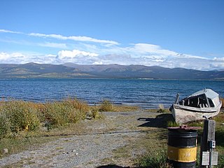
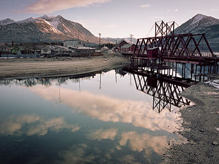
Burwash Landing is a small community, at historical mile 1093 on the Alaska Highway, in Yukon, Canada along the southern shore of Kluane Lake.

The Pelly River is a river in Canada, and is a headstream of the Yukon River. The river originates west of the Mackenzie Mountains and flows 530 km (329 mi) long through the south central Yukon. The Pelly has two main tributaries, the Ross and Macmillan rivers.

Beaver Creek Airport is located 1 nautical mile northwest of Beaver Creek, Yukon, Canada, and is operated by the Yukon government. The gravel runway is 3,745 ft (1,141 m) long and is at an elevation of 2,131 ft (650 m).

Burwash Airport is located 2 nautical miles northwest of Burwash Landing, Yukon, Canada, and is operated by the Yukon government.

Dawson City Airport is located 8 nautical miles east of Dawson City, Yukon, Canada, in the Klondike River valley, and is operated by the Yukon government. It has a terminal building and a runway which was recently paved in May 2019. The asphalt runway is 5,003 ft × 100 ft long and at an elevation of 1,215 ft (370 m). A number of studies have recommended moving the airport or realigning the runway as it is in a narrow mountain valley.

Faro Airport,, is located 1.5 nautical miles south of Faro, Yukon, Canada, and is operated by the Yukon government. The gravel runway is 3,997 ft (1,218 m) long and is at an elevation of 2,350 ft (716 m).
Mayo Airport is located 1.5 nautical miles north of Mayo, Yukon, Canada, and is operated by the Yukon government.

Teslin Airport is located on the northwest side of Teslin, Yukon, Canada, and is operated by the Yukon government. The gravel runway is 5,000 ft (1,524 m) long and is at an elevation of 2,313 ft (705 m).

Kugaaruk Airport, formerly known as Pelly Bay Townsite Airport, is located at Kugaaruk in Nunavut, Canada. It is operated by the government of Nunavut.
Pelly Crossing is a community in Yukon, Canada. It lies where the Klondike Highway crosses the Pelly River. Population in 2008 was 291.

Braeburn Airport, also known as the Cinnamon Bun Airstrip, in the Yukon, Canada, is adjacent to the Klondike Highway between Whitehorse and Carmacks. It is next to Braeburn Lodge and near Braeburn Lake. It receives no maintenance and pilots are advised to use caution as there are numerous holes in the runway caused by gophers.
Wiley Aerodrome formerly Eagle Plains/Wiley Aerodrome is a registered aerodrome located 12 nautical miles north of Eagle Plains, Yukon, Canada.
Finlayson Lake Airport is located adjacent to the south side of the Robert Campbell Highway near Ross River, Yukon, Canada.

Haines Junction Airport is located 2 nautical miles northwest of Haines Junction, Yukon, Canada. The airport has no scheduled airline service and is served by one fixed wing charter and two helicopter operators. Haines Junction is the gateway to Kluane National Park and Reserve. The airport is also the headquarters for the Yukon Governments Community and Transportation Services Airport Division.
Whitehorse/Cousins Airport is an unpaved airstrip located in Whitehorse, Yukon, Canada, 8 nautical miles northwest of the city centre between the Alaska Highway and the Yukon River. This airport has no services at all, and is used primarily as an emergency landing area and for local pilot training. Vehicles enter via Cousins Access Road. The airport was built to support the Alaska Highway construction and the Northwest Staging Route.

Del Bonita is a hamlet in southern Alberta, Canada within Cardston County. It is located approximately 49 km (30 mi) south of Magrath at the junction of Highway 62 and Highway 501. Due to its location near the Canada–United States border, it serves as a port of entry into the U.S. state of Montana at the nearby Del Bonita Border Crossing which is located 3 km (1.9 mi) to the south. Del Bonita is a name derived from Spanish meaning "of the pretty".
